The drought indeed hits home: Berkeley water less than its usual quality

The hills and lawns might look green still, but the drought has hit the east bay hard. The sparkling, clean, tasty water we usually have delivered through our taps via  the Mokelumne River Basin in the Sierra Nevada. Get out Britas!

From our favorite and fastest source for local news Berkeleyside

The drinking water for 1 million customers of East Bay Municipal Utilities District had an “off” odor and taste over the weekend and, while EBMUD is fixing the issue, customers might have to get used to it. The culprit? The drought.

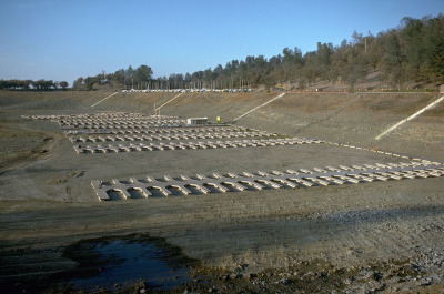
EBMUD usually draws the drinking water for the majority of its customers from the bottom of Pardee Reservoir, about 100 miles east of Berkeley, according to Abby Figueroa, a spokeswoman for EBMUD. But on Thursday, the water district started taking water from the top portion of the reservoir. The water there is warmer and contains some algae, so even though it was treated before gushing into pipes in Berkeley, Oakland and elsewhere, there was a peculiar smell.

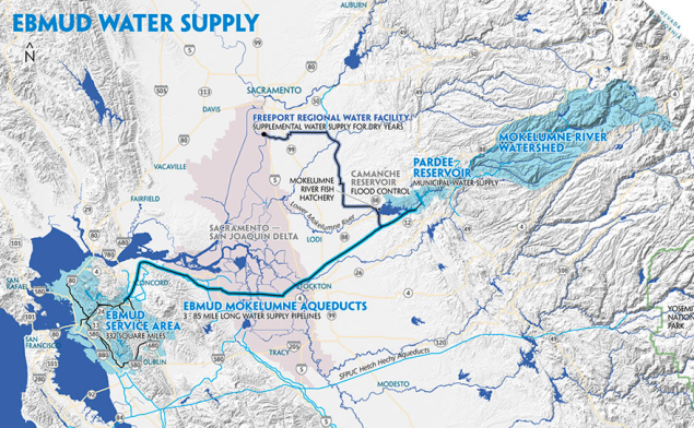
Route from the Mokelumne River Basin in the Sierra Nevada, to the East BayAccordingly there was a run on Brita filters at all local hardware/houseware stores.

New water restrictions for California announced.

VTM data helps us understand changes to California forests

Some press on our PNAS paper: Twentieth-century shifts in forest structure in California: Denser forests, smaller trees, and increased dominance of oaks.

In the paper we document changes in forest structure between historical (1930s) and contemporary (2000s) surveys of California vegetation. The shorthand is:

  1. Statewide, tree density in forested regions increased by 30% between the two time periods, and forest biomass declined by 19%.
  2. Larger trees (>60 cm diameter at breast height) declined, whereas smaller trees (<30 cm) have increased.
  3. Large tree declines were more severe in areas experiencing greater increases in climatic water deficit since the 1930s.
  4. Forest composition in California in the last century has also shifted toward increased dominance by oaks relative to pines, a pattern consistent with warming and increased water stress, and also with paleohistoric shifts in vegetation in California over the last 150,000 years.

California Water Blog talks about our future

Boat slips in Folsom Lake in a drought (1976). The reservoir was at 18 percent of capacity on Tuesday (Jan. 7, 2013). Source: California Department of Water ResourcesAs a follow-up to this disasterous news about California's water situation, here is a very thought provoking blog about California's water future. They list their 10 predictions for our changed future, including:

  • Parts of the Sacramento-San Joaquin Delta will permanently flood.
  • The Tulare Basin and San Joaquin River regions will have less irrigated agriculture.
  • Urban areas will use less water per capita, reuse more wastewater and capture more stormwater.

Check out the California Water Blog - Resistance is futile: Inevitable changes to water management in California.

http://californiawaterblog.com/2014/01/07/resistance-is-futile-inevitable-changes-to-water-management-in-california/.

map of global routes of ship-borne invasive species

From the BBC. Scientists have developed the first global model that analyses the routes taken by marine invasive species. The researchers examined the movements of cargo ships around the world to identify the hot spots where these aquatic aliens might thrive. The research is published in the Journal Ecology Letters.

Scientists mapped the global routes taken by cargo ships over a two-year period

Marine species are taken in with ballast water on freighters and wreak havoc in new locations, driving natives to extinction.

There has been a well-documented boom in global shipping over the past 20 years and this has led to growing numbers of species moving via ballast tanks, or by clinging to hulls.

Some ports such as San Francisco and Chesapeake Bay have reported several exotic new species arriving every year. Economic estimates indicate that marine invaders can have huge impacts that last for decades.

Now, scientists from the UK and Germany have developed a model that might help curb these unwanted visitors. They obtained detailed logs from nearly three million voyages that took place in 2007 and 2008. The model combines information such as shipping routes, ship sizes, temperatures and biogeography to come up with local forecasts of invasion probabilities.

forests to faucets: cool new tool from the forest service

The US Forest Service has released their "forest to faucet" program last week. It looks at the importance of forests to surface water. Built in ArcGIS server, it quickly maps, by watershed:

  • Surface Drinking Water Importance Index   
  • Index of Forest Importance to Surface Drinking Water   
  • Index of insect and disease threat to forests important to surface drinking water   
  • Index of development threat to forests important to surface drinking water
  • Index of wildland fire threat to forests important to surface drinking water

Check it out: http://www.fs.fed.us/ecosystemservices/FS_Efforts/forests2faucets.shtml