Open Access journal articles and others where possible are linked to an external source. My Google Scholar page is here.
2025
Kelly, M, S Feirer, S Hogan, A Lyons, F Lin, and E Jacygrad. 2025. Mapping orchard trees from UAV imagery through one growing season: A comparison between OBIA-based and three CNN-based object detection methods. Drones: 2025, 9, 593

Results from the month of June for three CNNS
We evaluated three CNN models - MASK R-CNN, YOLOv3, and SAM - and compared their tree crown results with OBIA-based reference datasets from UAV imagery for seven dates across one growing season. We wanted to contribute insight into which CNN model offers the best balance of accuracy and ease of implementation for orchard management tasks, and to evaluate their applicability within one software ecosystem, ESRI ArcGIS Pro.
2024
Hu, T, M Cao, X Zhao, X Liu, Z Liu, L Liu, X Huang, S Tao, Z Tang, L Liu, M Kelly, J Fang, and Y Su. 2024. High-resolution mapping of grassland canopy cover in China through the integration of extensive drone imagery and satellite data. ISPRS Journal of Photogrammetry and Remote Sensing 218: 69–83
We used drone imagery combined with multisource remote sensing data to map grasslands across China. The resulting high-resolution canopy cover map of China holds great potential in advancing our comprehension of grassland ecosystem processes and advocating for the sustainable management of grassland resources.
Taylor, A, I Dronova, A Sigona, and M Kelly. 2024. Using Sentinel-2 imagery to measure spatiotemporal changes and recovery across three adjacent grasslands with different fire. Remote Sensing 16, 2232
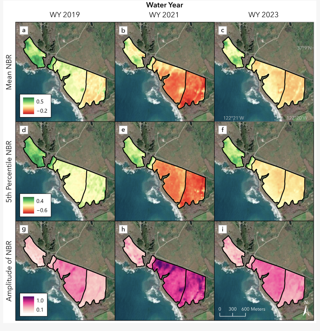
We propose novel metrics (mean, fifth percentile, and amplitude) derived from normalized burn ratio (NBR) from multi-date Sentinel imagery to address a growing need to study the effects of small, intentional burns in low-biomass ecosystems such as grasslands, which are an essential part of mitigating wildfires.
Taylor, A, A Sigona, and M Kelly. 2024. Centering Amah Mutsun voices in the analysis of a culturally important, fire-managed coastal grassland. Ecological Applications 2024: e3014
This paper makes an important contribution towards describing differences and similarities between cultural burning and land stewardship and western-centric research and management practices in California grassland ecosystems, as well as potential ways to weave these perspectives together for future land management.
Wilkinson, C E, C Chepkisich, W Xu, A Solli, J S Brashares, G Osuka, and M Kelly. 2024. Social–ecological predictors of spotted hyena navigation through a shared landscape. Ecology and Evolution. 2024;14:e11293
Using high-resolution GPS collar data, we applied resource selection functions and step selection functions to assess spotted hyena landscape navigation and fine-scale movement decisions in relation to social–ecological features in a rapidly developing region comprising two protected areas: Lake Nakuru National Park and Soysambu Conservancy, Kenya.
2023
Ma, Q, Y Su, C Niu, Q Ma, T Hu, X Luo, X Tai, T Qiu, Y Zhang, RC Bales, L Liu, M Kelly, and Q Guo. 2023. Structurally complex forests reduce tree mortality during long-term droughts. Nature Communications 14:7467
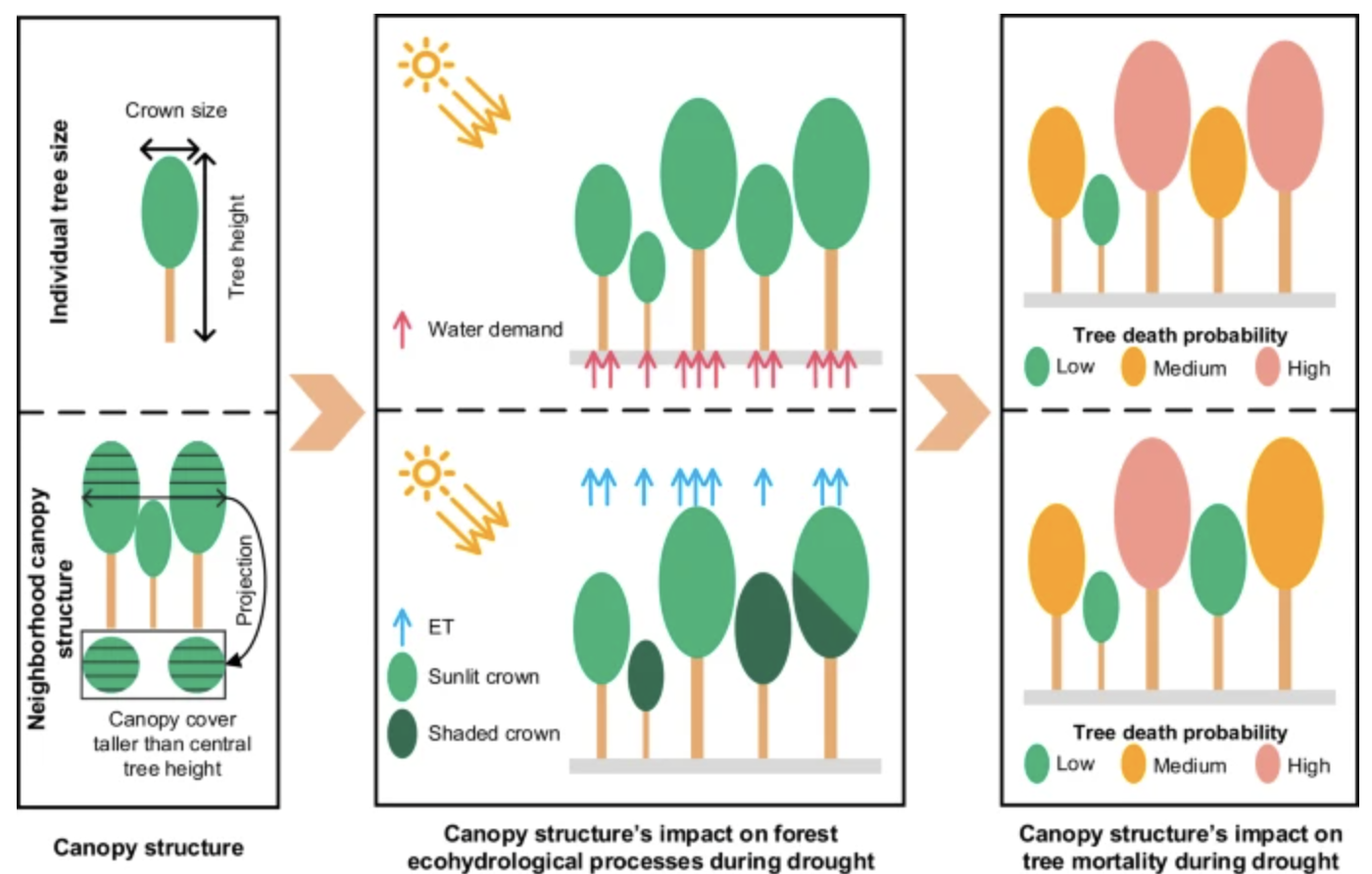
A conceptual diagram of the influence of canopy structure on tree mortality during drought
Using lidar data from nearly 1.5 million trees during the 2012-2016 California drought, we found that trees in a structurally complex forest with tall neighboring trees experienced lower mortality rate, likely because of the lower solar radiation and less water demand through evapotranspiration.
Zhao, Su, Feng, Xu, Cao, Hu, Yang, Liu, Ma, Hu, Kelly, Liu, and Guo. 2023. Canopy structure: An intermediate factor regulating grassland diversity-function relationships under human disturbances. Fundamental Research 3(2): 179-187
This study highlights that canopy structure is an important intermediate factor regulating grassland diversity-function relationships under human disturbances, which should be included in future grassland monitoring and management.
Taylor, A, A Sigona, and M Kelly. 2023. Modeling spatial distributions of Amah Mutsun priority cultural plants to support Indigenous cultural revitalization. Ecosphere 14(1): January, e4374

We identified potential gathering areas for culturally important plants by modeling the spatial distributions of ten plants throughout the Amah Mutsun Tribe’s stewardship area. We utilized community science datasets with an ensemble modeling approach.
2022
Jacygrad, M Kelly, S Hogan, J E Preece, D Golino, and R Michelmore. 2022. Comparison between field measured and UAV-derived Pistachio tree crown characteristics throughout a growing season. Drones 6(11): 343
Monitoring individual tree crown characteristics is an important component of smart agriculture and is crucial for orchard management. We focused on understanding how UAV imagery taken across one growing season can help understand and predict the growth and development of pistachio trees grown from rootstock seedlings. Part of the Special Issue: UAS in Smart Agriculture.
Yang, Q, Y Su, T Hu, M Kelly, Q Guo. 2022. Allometry-based estimation of forest aboveground biomass combining LiDAR canopy height attributes and optical spectral indexes. Forest Ecosystems 9: 100059
Accurate estimates of forest aboveground biomass (AGB) are essential for global carbon cycle studies. We present a new approach for forest AGB modeling based on allometric relationships that integrate structural (from lidar) and spectral (from Sentinel-2 imagery) information.
Kislik, C, I Dronova, T Grantham, and M Kelly. 2022. Mapping Algal Bloom Dynamics in Small Reservoirs of Northern California using Sentinel-2 Imagery in Google Earth Engine. Ecological Indicators 140: 109041
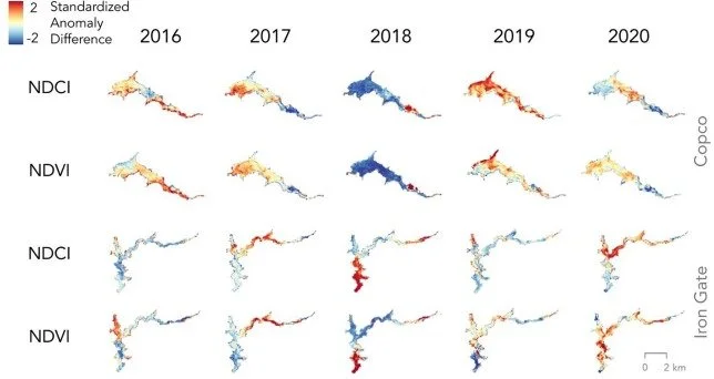
Standardized anomaly differences across time for two reservoirs in northern california
We found that the spectral index NDCI can quantify algal bloom spatiotemporal heterogeneity in small reservoirs using Google Earth Engine. Our results provide baseline aquatic research for the largest dam removal in history.
2021
Hahn, M, S Feirer, R Eisen, R Lane, A Mognahan, and M Kelly. 2021 Modeling future climate suitability for the western blacklegged tick, Ixodes pacificus, in California with a focus on land access and ownership. Ticks and Tick Borne Diseases 12(5), 101789
We explore how climate change may alter the geographic distribution of I. pacificus in California, USA, during the 21st century, and the spatial overlap among predicted changes in tick habitat suitability, land access, and ownership.
Wilkinson, C, J. Brashares, AC Bett, and M Kelly. 2021. Examining drivers of divergence in recorded vs perceived human-carnivore conflict hotspots using integrated participatory and ecological data. Frontiers in Conservation Science 2: 681769
We mapped densities of recorded and perceived risk of human-carnivore conflict and then tested for potential social and ecological predictors of divergences found between the two datasets. Mismatched hotspots of observed and perceived risk of conflict were correlated with several ecological and socioeconomic factors.
Dronova, I, C Kislik, Z Dinh, and M Kelly. 2021. A review of unoccupied aerial vehicle use for wetland applications: Emerging opportunities in approach, technology, and data. Drones 5(2), 45
From the review: project goal and method used, shaded by the number of references reviewed; pie charts show sensor types used for each goal and method category
Recent developments in Unoccupied Aerial Vehicles (UAVs) have revolutionized the scope of ecosystem monitoring, particularly for wetlands. This study presents a scoping review of 122 case studies from 29 countries, showing the current status and emerging opportunities in wetland UAV applications, with particular emphasis on wetland monitoring and management objectives that are most served by UAVs, and what workflows were employed to analyze these data.
Wilkinson, C, A M McIntrurf, M Kelly, and J Brashares. 2021. Quantifying wildlife responses to conservation fencing in East Africa. Biological Conservation 256: 109071
Popular, ‘one-size-fits-all’, conservation fence designs may be ineffective and costly for restraining movement of many wildlife species. We recommend that those deploying conservation fences start with clearly articulated management goals, that fence maintenance be informed by taxa-specific tendencies to breach fences, and that managers consider the strategic creation of wildlife corridors, overpasses, or ungulate-proof fences to link fenced protected areas with surrounding habitat.
Hu, T, Y Su, H Guan, Q Sun, X Sun, M Kelly, Q Guo. 2021. Development and performance evaluation of a very low-cost UAV-lidar system for forestry applications. Remote Sensing 13(1): 77
We tested a low-cost lidar-UAV ($600) system for estimating tree height, canopy cover, gap fraction, and leaf area index (LAI) and found it compared well high-end systems, with some systematic biases in areas with medium to high canopy densities.
Guo, Q, Y Su, T Hu, H Guan, S Jin, J Zhang, X Zhao, K Xu, D Wei, M Kelly, and N Coops. 2021. Lidar boosts three-dimensional ecological observations and modelling: A review and perspective. IEEE Geoscience and Remote Sensing 9(1): 232-257
Lidar has revolutionized the way we observe and measure vegetation from the ground and from above and represents a major advance toward the accurate quantification of 3D structure. We provide a review of lidar applications to 3D ecological observation and modelling.
2020
Beller, E, L Larsen, and M Kelly. 2020. From savanna to suburb: effects of 160 years of landscape change on carbon storage in Silicon Valley, California. Landscape and Urban Planning 195: 103712
We used historical archival sources and land-cover data to quantify and map historical tree carbon storage in the now-urban Santa Clara Valley, California, USA prior to substantial Euro-American modification (ca. 1850) and to analyze change in the amount and distribution of carbon storage over the past ca. 160 years.
Kislik, C, L Genzoli, A Lyons and M Kelly. 2020. Application of unmanned aerial vehicle imagery to detect and quantify submerged filamentous algae and rooted macrophytes in a non-wadeable river. Drones; 12(20): 3332 (She Maps special issue)

Showing the setup for the experiment
Upcoming dam removals are expected to alter the species composition and abundance of benthic filamentous algae and rooted macrophytes in rivers, and aerial imagery provides an effective method to monitor these changes. This study provides a novel application of UAV imagery analysis for monitoring benthic communities in a deep and fast-moving river.
2019
Yang, Q, Y Sua, S Jin, M Kelly, Q Ma, T Hu, Y Li, J Zhang, G Xu, and Q Guo. 2019. The influence of vegetation characteristics on individual tree segmentation methods with airborne LiDAR data. Remote Sensing 11(23): 2880
This study investigated the effects of forest type, leaf area index, canopy cover, tree density, and the coefficient of variation of tree height on the accuracy of different individual tree segmentation methods (i.e., canopy height model, pit-free canopy height model, point cloud, and layer stacking seed point) with LiDAR data.
Pei, J, L Wang, X Wang, Z Niu, M Kelly, X Song, N Huang, J Geng, H Tian, Y Yu, S Xu, L Wang, Q Ying, and J Cao. 2019. Landsat time series shows vegetation recovery in ecologically fragile karst regions of southwest China from 1988-2016. Remote Sensing 11(17), 2044
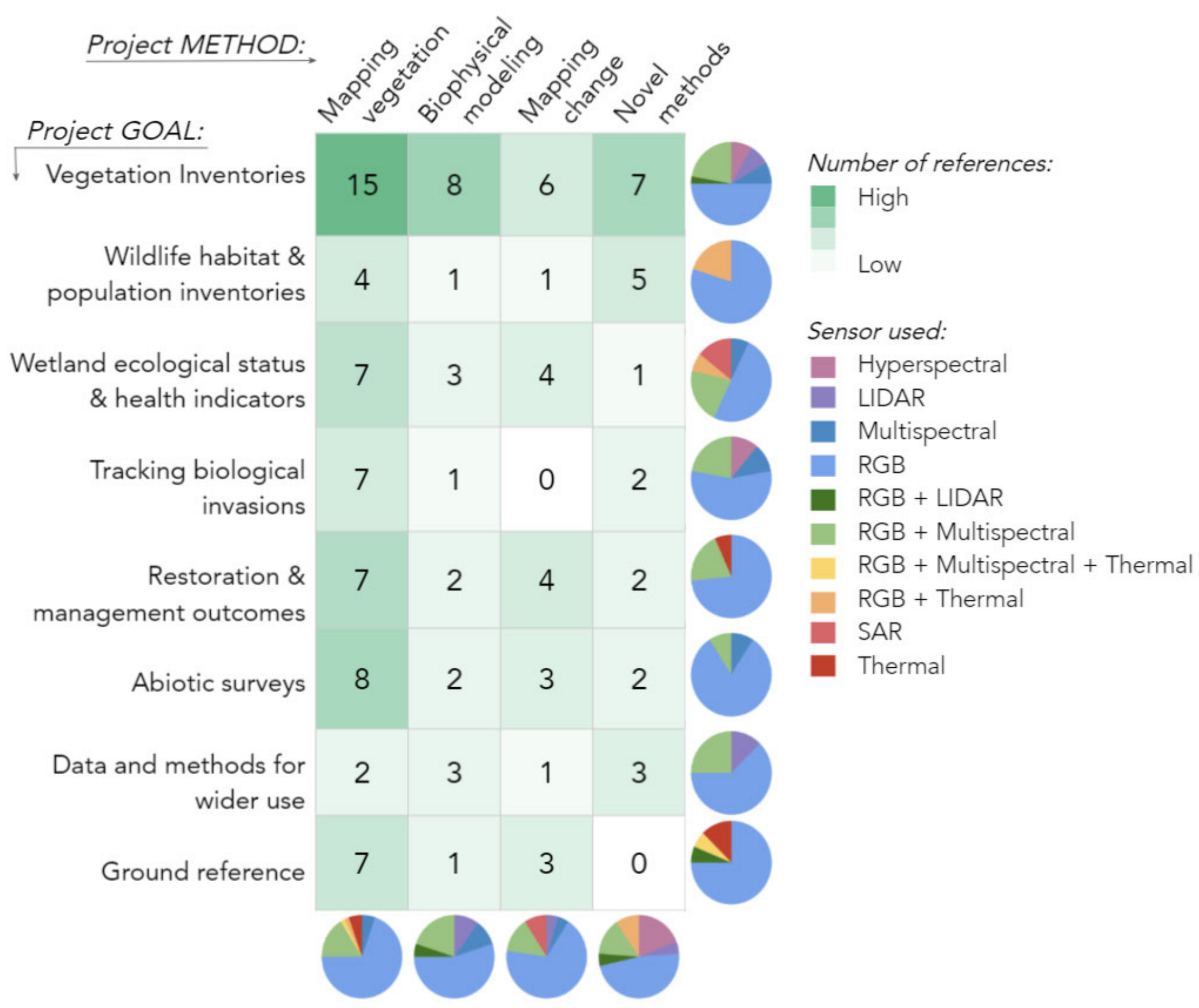
Easterday, K, C Kislik, T E Dawson, S Hogan, and M Kelly. 2019. Remotely sensed water limitation in vegetation: insights from an experiment with unmanned aerial vehicles (UAVs). Remote Sensing 11(16):1853
Looking at four common resolutions showing the study area
We used multispectral imagery from quadcopter UAVs to monitor the progression of a water manipulation experiment on a common shrub, Baccharis pilularis (coyote brush) at the Blue Oak Ranch Reserve (BORR) ~20 km east of San Jose, California. We recorded multispectral imagery at several altitudes with nearly hourly intervals to explore the relationship between two common spectral indices, NDVI (normalized difference vegetation index) and NDRE (normalized difference red edge index), leaf water content and water potential as physiological metrics of plant water status, across a gradient of water deficit.
Csillik, O, M Belgiu, G Asner and M Kelly. 2019. Object-based time-constrained dynamic time warping classification of crops using Sentinel-2. Remote Sensing 11(10), 1257
Increasing volume of remote sensing data with improved spatial and temporal resolutions generates unique opportunities for monitoring and mapping of crops. We compared multiple single-band and multi-band object-based time-constrained Dynamic Time Warping (DTW) classifications for crop mapping based on Sentinel-2 time series of vegetation indices.
Palomino, J and M Kelly. Differing sensitivities to fire disturbance result in large differences among remotely-sensed products of vegetation disturbance. Ecosystems https://doi.org/10.1007/s10021-019-00367-9
Wondering how different #Landsat products map disturbance? We compare #fire disturbance in #LANDFIRE, Global Forest Change (#GFC) and the North America Forest Dynamics (#NAFD) products in California using #GoogleEarthEngine. This work can help users choose the appropriate product for their needs.
Nikolaeva, S, K O’Hara and M Kelly. 2019. Implications of Forest Stewardship Council Certification for Forest Management in Primorsky Krai in the Russian Far East. Journal of Sustainable Forestry
Hu, T, Q Ma, Y Su, J J Battles, B M Collins, S Stephens, M Kelly and Q Guo. 2019. A simple and integrated approach for fire severity assessment using bi-temporal airborne LiDAR data. International Journal of Applied Earth Observations and Geoinformation 78: 25-38
We proposed a new LiDAR-based profile area change (PAC) method for fire severity assessment. PAC metrics are highly correlated to field measured changes in basal area and leaf area index. PAC metrics outperformed traditional LiDAR-based canopy cover and tree height change metrics, and Landsat-derived RdNBR.
2018
Csillik, O, J Cherbini, R Johnson, A Lyons, and M Kelly. 2018. Identification of citrus trees from UAV imagery using Convolutional Neural Networks. Drones 2(4), 39

Showing the CNN-captured trees across Lindcove REC
We detected citrus and other crop trees from UAV images using a simple convolutional neural network (CNN) algorithm, followed by a classification refinement using superpixels derived from a Simple Linear Iterative Clustering (SLIC) algorithm. The workflow performed well in a relatively complex agricultural environment with multiple targets, multiple size trees and ages, etc.
Kislik, C, I Dronova, and M Kelly. 2018. UAVs in support of algal bloom research: A review of current applications and future opportunities. Drones 2(4): 35
Unmanned aerial vehicles (UAVs) have recently emerged as another tool for algal bloom detection, providing users with on-demand high spatial and temporal resolution at lower costs. This review explores the current state of this field, and highlights opportunities that could promote its growth.
Easterday, KJ, T Paulson, P DasMohapatra, P Alagona, S Feirer and M Kelly. 2018. From the field to the cloud: A review of three approaches to sharing historical data from field stations using principles from data science. Frontiers in Environmental Science: 6:(88)
To encourage greater use of historical data across scientific disciplines it is vital to make data findable, accessible, interoperable, and reusable. We discuss the potential of historical dark data to contribute to the modern digital ecological data landscape by focusing on 3 cases from UC field and research stations and the groups that have worked to make historical dark data discoverable. Each case and the methods employed are unique, and showcase varying levels of success in achieving the FAIR principles and shepherding historical data into the 21st century.
Ma, Q, Y Su, L Luo, L Li, M Kelly, and Q Guo. 2018. Evaluating the uncertainty of Landsat-derived vegetation indices in quantifying forest fuel treatments using bi-temporal LiDAR data. Ecological Indicators 95(1): 298-310
Luo, L, Y Su, Q Ma, M Kelly, and Q Guo. 2018. A simple method for direct crown base height estimation of individual trees using airborne LiDAR data. Optics Express
We present a new method for directly estimating individual tree crown base height (CBH) from airborne LiDAR data.
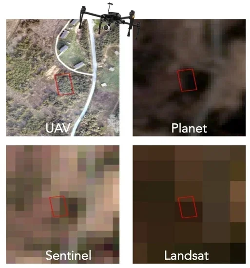
Eisen, RJ, S Feirer, A Monaghan, K Padgett, MB Hahn, and R Lane and M Kelly. 2018. A climate suitability model of the western blacklegged tick (Ixodes pacificus) in California forests, grasslands, scrub-shrublands and riparian areas. Journal of Medical Entomology 55 (5): 1133–1142
REsults from five suitability models showing possible tick habitat in California
We employed an ensemble species distribution modeling approach to identify suitable climatic conditions for Ixodes pacificus (the primary vector of Lyme disease in the western US) and restricted the results to land cover classes where these ticks are typically encountered (forest, grass, scrub-shrub, riparian).
Kelly, M, Y Su, S Di Tommaso, B Collins, D Fry, S L Stephens, and Q Guo. 2018. Impact of error in Lidar-derived canopy height and canopy base height on modeled wildfire behavior in the Sierra Nevada, California, USA. Remote Sensing 10(1): 10
We evaluated the influence of error associated with two Lidar data products -- canopy height (CH) and canopy base height (CBH) -- on simulated fire behavior.
Easterday, K, P McIntyre and M Kelly. 2018. Exploring the influence of land ownership on 20th century changes to forest structure in California. Forest Ecology and Management 422: 137–146
Understanding change to forests across land ownership is essential for their management. We compared historical and contemporary forest structural data by ownership class. We found consistent trends statewide, with important differences. Forest densification was largest on private timberlands. Private timberlands and national park/wilderness areas had largest large tree loss.
2017
Kelly, M, K J Easterday, M Koo, J H Thorne, S Mukythar and B Galey. 2017. Geospatial informatics key to recovering and sharing historical ecological data for modern use. Photogrammetric Engineering and Remote Sensing 83(11): 779–786
Boisrame, GF, SS Thompson, M Kelly, S Stephens, and J Cavalli. 2017. Vegetation Change Induced by Changing Fire Regime. Forest Ecology and Management 402: 241–252
Tsalyuk, M, M Kelly, and W Getz. 2017. Improving the measurement of African savanna vegetation using time series analysis of MODIS vegetation indices. ISPRS Journal of Photogrammetry and Remote Sensing 131: 77–91
We analyze time series of four MODIS Vegetation Products (VPs): Normalized Difference Vegetation Index (NDVI), Enhanced Vegetation Index (EVI), Leaf Area Index (LAI), and Fraction of Photosynthetically Active Radiation (FPAR) for Etosha National Park, a semiarid savanna in north-central Namibia, Africa. We create models to predict the density, cover, and biomass of savanna grass, shrubs, and trees.
Kelly, M 2017. Chapter 6: Mapping Forest Conditions Past, Present, and Future. In Gutiérrez, R J, P N Manley, and P A Stine, technical editors. The California spotted owl: current state of knowledge. Gen. Tech. Rep. PNWGTR-254. Albany, CA: U.S. Department of Agriculture, Forest Service, Pacific Southwest Research Station. 294 p.
Mapping technology has been critical to understanding the ways owls use their forest habitat and to help manage forests for their sustainability. I reviewed papers published from 1992 - 2013 that described the use of remote sensing, aerial imagery, or other mapped products to assess forest structure used by California spotted owls across scales and that also were specific about mapping protocols.
Palomino, J, O Muellerklein, and M Kelly. 2017. A review of the emergent ecosystem of collaborative geospatial tools for addressing environmental challenges. Computers, Environment and Urban Systems 65: 79-92
We develop a typology of the emerging landscape of collaborative geospatial tools (those that use large, multi-scale, multi-temporal, and multi-dimensional spatial data to help collaborators share data, code, and results). Our typology is based on 31 tools, and uses a novel modified K-means clustering algorithm. We identify three primary clusters of tools, driven by required infrastructure and user involvement.
Laraia, B, J Downing,, Y T Zhang, W Dow, M Kelly, S D Blanchard, N Adler, D Schillinger, H H Moffet, M Warton, and A J Karter. 2017. Food environment and weight change: does residential mobility matter? The Diabetes Study of Northern California (DISTANCE). American Journal of Epidemiology 1-8.
Kelly, M. 2017. Drones in California research and extension. California Agriculture 71(1): 4
Drones are revolutionizing the way we collect data about agricultural and natural resources, and the University of California is poised to be a leader in this emerging field.
Hogan, S D, M Kelly, B Stark, and Y Chen. 2017. Unmanned aerial systems for agriculture and natural resources. California Agriculture 71(1): 5-14
Schile, L M, J C Callaway, K N Suding, and N M Kelly. 2017. Can community structure track sea-level rise? Stress and competitive controls in tidal wetlands. Ecology and Evolution 1(1): 1-10
We simulated sealevel rise across existing and potential marsh elevations in two tidal wetlands differing in salinity. Plants were grown individually and together at five tidal elevations and harvested to assess differences in biomass after one growing season. Increasing inundation reduced biomass of the species commonly found at higher marsh elevations, with little effect on the species found along channel margins.
2016
Kramer, H A, B M Collins, C V Gallagher, J Keane, S L Stephens, and M Kelly. 2016. Accessible LiDAR: estimating large tree density for habitat identification. Ecosphere 7(12): e01593
This study derived a simple and effective method for estimating the density of large-stemmed trees from the LiDAR canopy height model, a standard raster product derived from the LiDAR point cloud that is often delivered with the LiDAR and is easy to process by resource managers trained in geographic information systems (GIS)
Easterday, KJ, P J McIntyre, J Thorne, MJ Santos, and M Kelly. 2016. Assessing threats and conservation status of historical centers of oak richness in California. Urban Planning 1(4): 65–78

5 areas of historical oak richness in California
We investigated the effects of human urban development on oak species in California by modeling historical patterns of richness for 8 oak tree species using historical map and plot data VTM collection, and then examined spatial intersections between hot spots of historical oak richness and modern urban and conservation lands.
Tamayo, A, M S Mahasin, B A Laraia, E M Warton, S D Blanchard, N M Kelly, H H Moffet, N Adler, D Schillinger, and A J Karter. 2016. Police Recorded Crime and Perceived Stress Among Patients with Type 2 Diabetes: The Diabetes Study of Northern California (DISTANCE). Journal of Urban Health 93(50): 745–757
Kelly, M, K J Easterday, G Rapacciuolo, M S Koo, P Mcintyre, and J Thorne. 2016. Rescuing and sharing historical vegetation data for ecological analysis: The California Vegetation Type Mapping project. Biodiversity Informatics 11: 40-62
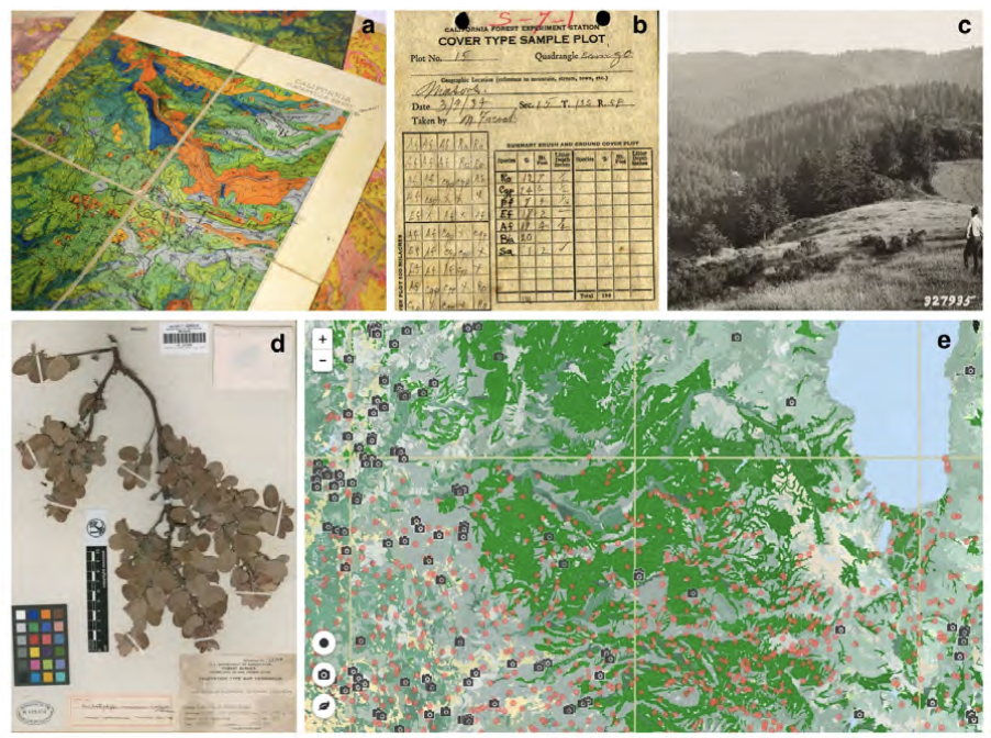
the various types of VTM data: Maps, plots, photos, specimens.
Research efforts that synthesize historical and contemporary ecological data with modeling approaches improve our understanding of the complex response of species, communities, and landscapes to changing biophysical conditions through time and in space. Historical ecological data are particularly important in this respect.
Kramer, H A, B M Collins, F K Lake, M K Jakubowski, M Kelly, and S L Stephens 2016. Estimating ladder fuels: a new approach combining field photography with LiDAR. Remote Sensing 8(9), 766
Xiao, P, X Zhang, D Wang, M Yuan, X Feng, M Kelly. 2016. Change detection of built-up land: A framework of combining pixel-based detection and object-based recognition. ISPRS Journal of Photogrammetry and Remote Sensing 119; 402–414
We propose a new framework that combines pixel-level change detection and object-level recognition to detect changes of built-up land from high-spatial resolution remote sensing images.
Su, Y, Q Guo, B M Collins, D Fry, and M Kelly. 2016. Forest fuel treatment detection using multi-temporal airborne Lidar data and high resolution aerial imagery: A case study in the Sierra Nevada, California. International Journal of Remote Sensing 37(14): 3322–3345
Identifying the actual extent of fuel treatments in forests is of primary importance to understand their influence. Lidar is a powerful remote sensing tool that can provide accurate measurements of forest structures and has great potential for monitoring forest changes. We use canopy height model and canopy cover products derived from multi-temporal Lidar data to monitor forest changes following the implementation of landscape-scale fuel treatments.
Müller, M F, S E Thompson, and M Kelly. 2016. Bridging the information gap: A webGIS tool for rural electrification in data-scarce regions. Applied Energy 171(1): 277-286
We present a method to site, size and evaluate the potential for micro hydropower based on remote sensing data.
Su, Y, Q Guo, DL Fry, BM Collins, M Kelly, JP Flanagan, and JJ Battles. 2016. A vegetation mapping strategy for conifer forests by combining airborne lidar data and aerial imagery. Canadian Journal of Remote Sensing 42:1–15
We introduce a strategy using both multispectral aerial imagery and Lidar data to map vegetation composition and structure over large spatial scales.
Eitzel, M V, M Kelly, I Dronova, J Solera, and P de Valpine. 2016. Challenges and opportunities in synthesizing historical geospatial data using statistical models. Ecological Informatics 31 (2016): 100-111
We classified land cover types from 1940s historical aerial imagery using Object Based Image Analysis (OBIA) and compared these maps with data on recent cover.
2015
Tempel, D. J., R. J. Gutiérrez, J. J. Battles, D. L. Fry, Y. Su, Q. Guo, M. J. Reetz, S. A. Whitmore, G. M. Jones, B. M. Collins, S. L. Stephens, M. Kelly, W. J. Berigan, and M. Z. Peery. 2015. Modeling short- and long-term impacts of fuel treatments and wildfire on an old-forest species. Ecosphere 6(12): Article 261
Fuels-reduction treatments are commonly implemented in the western US to reduce the risk of high-severity fire, but they may have negative short-term impacts on species associated with older forests. We modeled the effects of a completed fuels-reduction project on fire behavior and California spotted owl (Strix occidentalis occidentalis) habitat and demography in the Sierra Nevada to assess the potential short- and long-term trade-offs.
O’Connnell, J., K. Byrd, and M. Kelly. 2015. A hybrid modeling approach for mapping relative differences in belowground biomass and root:shoot ratios using spectral reflectance, foliar N and plant biophysical data. Remote Sensing 7, 16480-16503
We used remotely-sensed estimates of two aboveground plant characteristics, aboveground biomass and % foliar N to explore biomass allocation in low diversity freshwater impounded peatlands (Sacramento-San Joaquin River Delta, CA, USA).
Turpie, K, V V Klemas, K Byrd, M Kelly, J Heon-Young. 2015. Prospective HyspIRI global observations of tidal wetlands. Remote Sensing of Environment 16: 206-217
This paper describes how the HyspIRI hyperspectral and thermal infrared sensors can be used to study and map key ecological properties, such as species composition, biomass, hydrology, and evapotranspiration of tidal salt and brackish marshes and mangroves, and perhaps other major wetland types, including freshwater marshes and wooded/shrub wetlands.
Lei, S. and M. Kelly. 2015. Evaluating adaptive collaborative management in Sierra Nevada forests by exploring public meeting dialogues using Self-Organizing Maps. Society and Natural Resources (28)8: 873-890
Results of Self-organizing maps from 10 years of public meetings
Self-organizing maps (SOM), an unsupervised machine-learning method, were used to process, organize, and visualize public meeting notes from a decade of public meetings as part of the Sierra Nevada Adaptive Management Project (SNAMP).
Kelly, M. and S. Di Tommaso. 2015. Mapping forests with Lidar provides flexible, accurate data with many uses. California Agriculture 69(1): 14-20
The use of remote sensing for forest inventory, fire management, and wildlife habitat conservation planning has a decades-long and productive history, especially in California. This paper reviews this use, and highlights Lidar remote sensing.
Lei, S., A. Iles, and M. Kelly. 2015. Characterizing the networks of digital information that support collaborative adaptive forest management in Sierra Nevada forests. Environmental Management 56(1): 94-109
We use powerful new information monitoring tools to characterize information products generated in the SNAMP program through their production, transport, use, and monitoring.
Zhang, Y.T., B.A. Laraia, M.S. Mujahid, A. Tamayo, S.D. Blanchard, E.M. Warton, M. Kelly, H.H. Moffet, D. Schillinger, N. Adler, and A.J. Karter. 2015. Does food vendor density mediate the association between neighborhood deprivation and BMI?: A G-computation mediation analysis. Epidemiology 26(3): 344-52
We assessed whether the association between neighborhood deprivation and BMI is attributable, in part, to geographic variation in the availability of healthful and unhealthful food vendors.
Tsalyuk, M., M. Kelly, K. Koy, Wayne M. Getz, and H. S. Butterfield. 2015. Monitoring the Impact of Grazing on Rangeland Conservation Easements Using MODIS Vegetation Indices. Journal of Rangeland Management 68(2): 173–185
Residual dry matter (RDM), the dry grass biomass left on the ground in the fall, is a widely used proxy for rangeland conditions. We developed a method to efficiently monitor RDM using time series of three Moderate Resolution Imaging Spectroradiometer (MODIS) satellite-based vegetation indices (VIs).
Li, L., Q. Guo, S. Tao, M. Kelly, and G. Xu. 2015. Lidar with multi-temporal MODIS provide a means to upscale predictions of forest biomass. ISPRS Journal of Photogrammetry and Remote Sensing 102: 198–208
We use airborne Lidar to bridge the scale gap between satellite-based and field-based studies, and evaluate satellite-derived indices to estimate regional forest aboveground biomass.
Butsic, V., M. Kelly, M. Moritz. 2015. Land use and wildfire: a review of local interactions and teleconnections. Land 4(1): 140-156
We review the nuanced land use teleconnections between wildfire and land use.
McIntyre, P.J., J.H. Thorne, C.R. Dolanc, A.L. Flint, L.E. Flint, M. Kelly, and D.D. Ackerly. 2015. 20th century shifts in forest structure in California: denser forests, smaller trees, and increased dominance of oaks. Proceedings of the National Academy of Sciences 112(5): 1458-1463

Main results from this work: big trees decline with changes in water deficit
We document changes in forest structure between historical (1930s) and contemporary (2000s) surveys of California vegetation through comparisons of tree abundance and size across the state and within several ecoregions. Across California, tree density in forested regions increased by 30% between the two time periods, whereas forest biomass in the same regions declined, as indicated by a 19% reduction in basal area.
Lewis, S., S. Gross, A. Visel, M. Kelly, and W. Morrow. 2015. Fuzzy GIS-based multi-criteria evaluation for U.S. Agave production as a bioenergy feedstock. Global Change Biology Bioenergy 7: 84–99 doi: 10.1111/gcbb.12116
In the US renewable energy mandates calling for increased production of cellulosic biofuels will require a diversity of bioenergy feedstocks to meet growing demands, and plants within the genus Agave promise to be a productive feedstock in hot and arid regions. The potential distributions of Agave tequilana and Agave deserti in the United States were evaluated based on plant growth parameters identified in an extensive literature review.
2014
Kelly, A.B, and M. Kelly. 2014. Validating the remotely sensed geography of crime: A review of emerging issues. Remote Sensing 6(12): 12723-12751
We explore the existing literature (61 papers as of Dec 2014) on the active detection of crimes using remote sensing technologies, and ask critical questions about efficacy, technology and implications.
Laraia, B.A., S.D. Blanchard, A.J. Karter, J.C. Jones-Smith, E.M. Warton, E. Kersten, M. Jerrett, H.H. Moffett, N. Adler, D. Schillinger and M. Kelly. 2014. Spatial pattern of Body Mass Index among adults in the Diabetes Study of Northern California (DISTANCE). International Journal of Health Geographics 13:48
We evaluated the extent to which spatial clustering of extreme body mass index (BMI) values among a large sample of adults with diabetes was explained by individual characteristics and contextual factors.
Ferranto, S., L. Huntsinger and M. Kelly. 2014. Sustaining ecosystem services from private lands in California: the role of the landowner. Rangelands 36(5): 44-51
Landowner participation in sustaining ecosystem services means conservation initiatives need to build on landowner management objectives, practices, and goals, and encourage collaboration across multiple parcels.
Tao, S., Li, L., Q. Guo, L. Li, B. Xue, M. Kelly, W. Li, G. Xu, and Y. Su. 2014. Airborne Lidar-derived volume metrics for aboveground biomass estimation: A comparative assessment for conifer stands. Agriculture and Forest Management 198–199 (2014) 24–32
We compared a range of airborne Lidar-derived volume metrics (i.e. stem volume, crown volume under convex hull, and crown volume under Canopy Height Model (CHM)) to estimate aboveground biomass.
Kramer, H. A., B. Collins, M. Kelly, S. Stephens. 2014. Quantifying ladder fuels in forests: a new approach using LiDAR. Forests 5:1432-1453
We investigated the relationship between LiDAR and ladder fuels in the northern Sierra Nevada, California USA.
Byrd, K., J. O’Connell, S. Di Tomasso, and M. Kelly. 2014. Evaluation of sensor types and environmental controls on mapping biomass of coastal marsh emergent vegetation. Remote Sensing of Environment 149:166-180
We modeled biomass of emergent vegetation with field spectrometer and satellite data from Landsat, Hyperion and WorldView-2 sensors.
O’Connell, J. L., K. B. Byrd, and M. Kelly. 2014. Remotely-sensed indicators of N-related biomass allocation in Schoenoplectus acutus. PLOS One 9(3): e90870
We used N-addition and control plots (4 each) to test whether remotely-sensed vegetation indices could predict leaf N concentration, root:shoot ratios and belowground biomass of SSchoenoplectus acutus.
Lewis, S. and M. Kelly. 2014. Mapping the potential for biofuel production on marginal lands: differences in definitions, data and models across scales. ISPRS International Journal of Geo-Information 3(2), 430-459
We reviewed a collection of recent literature that mapped bioenergy potential on marginal lands at varying scales, and found that there is no common working definition of marginal land across all of these works. Specifically we found considerable differences in mapped results that are driven by dissimilarities in definitions, model framework, data inputs, scale and treatment of uncertainty.
Lewis, S. M., G. Fitts, M. Kelly, and L. Dale. 2014. A fuzzy logic-based spatial suitability model for drought-tolerant switchgrass in the United States. Computers and Electronics in Agriculture 103: 39-47

This paper outlines a spatial suitability modeling approach to map potential for switchgrass that incorporates fuzzy logic and utilizes both physical and economic variables.
Schile, L. M., J. C. Callaway, J. T. Morris, D. Stalberg, V. T. Parker, and M. Kelly. 2014. Modeling tidal marsh distribution with sea-level rise: evaluating the role of vegetation, sediment, and upland habitat in marsh resiliency. PLOS One 9(2): e88760
We examined marsh resiliency under these uncertainties using the Marsh Equilibrium Model, a mechanistic, elevation-based soil cohort model, using a rich data set of plant productivity and physical properties from sites across the estuarine salinity gradient.
Blaschke, T., G. J. Hay, M. Kelly, S. Lang, P. Hofmann, E. Addink, R. Queiroz Feitosa, F. van der Meer, H. van der Werff, F. van Coillie, and D. Tiede. 2014. Geographic Object Based Image Analysis: a Paradigm in Remote Sensing and Geographic Information Science? ISPRS Journal of Photogrammetry and Remote Sensing 87(1), 180-191
We investigate development in OBIA and ask whether or not this is a new paradigm in remote sensing and Geographic Information Science (GIScience).
2013
Peña-Barragan, J. M., J. Torres-Sánchez, A. I. de Castro, M. Kelly, and F. López-Granados. 2013. Generating weed maps in early-season maize fields by using an unmanned aerial vehicle (UAV) and object-based image analysis. PLOS One 8(10): e77151
A robust and entirely automatic object-based image analysis (OBIA) procedure was developed on a series of UAV images using a six-band multispectral camera (visible and near-infrared range) with the ultimate objective of generating a weed map in an experimental maize field in Spain.
Pennypacker, C.R., M.K. Jakubowski, M. Kelly, M. Lampton, C. Schmidt, S. Stephens, and R. Tripp. 2013. FUEGO—Fire Urgency Estimator in Geosynchronous Orbit—A proposed early-warning fire detection system. Remote Sensing 5(10): 5173-5192
We propose the framework for a geosynchronous satellite with modern imaging detectors, software, and algorithms able to detect heat from early and small fires, and yield minute-scale detection times.
Ferranto, S., L. Huntsinger, C. Getz, W. Stewart, G. Nakamura, and M. Kelly. 2013. Management without borders? A survey of landowner practices and attitudes towards cross- boundary cooperation. Society and Natural Resources 26(9): 1082-1100
Results from a landowner survey in California were analyzed using an audience segmentation approach. Landowners were grouped into four clusters according to ownership motivations: rural lifestyle, working landscape, natural amenity, and financial investment.
Jakubowski, M. J., W. Li, Q. Guo, and M. Kelly. 2013. Delineating individual trees from lidar data: a comparison of vector- and raster-based segmentation approaches. Remote Sensing, 5: 4163-4186
This work concentrates on delineating individual trees from discrete lidar data in topographically-complex, mixed conifer forest across the California’s Sierra Nevada. We delineated individual trees using vector data and a 3D lidar point cloud segmentation algorithm, and using raster data with an object-based image analysis (OBIA) of a canopy height model (CHM).
Jones-Smith, J. C., M. Wharton, M. Kelly, E. Kersten, A. Karter, N. Adler, D. Schillinger, H. Moffett, and B. A. Laraia. 2013. Obesity and the food environment: income and ethnicity differences among people with diabetes, the Diabetes Study of Northern California (DISTANCE). Diabetes Care 36: 2697-2705
Schile, L. K. Byrd, L. Windham-Meyers, and M. Kelly. 2013. Accounting for plant litter in remote sensing based estimates of carbon flux in wetlands. Remote Sensing Letters 4:6, 542-551
We tested agricultural- and forest-based methods for estimating the fraction of absorbed photosynthetically active radiation (ƒAPAR), a key parameter for modeling gross primary productivity (GPP), in a restored, managed wetland with a dense litter layer of non-photosynthetic vegetation, and we compared the difference in canopy light transmission between a tidally influenced wetland and the managed wetland.
Jakubowski, M. Q. Guo, B. Collins, S. Stephens, and M. Kelly. 2013. Prediction of fuel models and stand structure metrics using lidar and optical remote sensing in dense mixed conifer forest. Photogrammetric Engineering and Remote Sensing 79(1): 37-50 (ASPRS Award*)

We compared the ability of several classification and regression algorithms to predict forest stand structure metrics and standard surface fuel models.
Brown, G., M. Kelly and D. Whital. 2013. Which “public”? Sampling effects in public participation GIS (PPGIS) and Volunteered Geographic Information (VGI) systems for public lands management. Journal of Environmental Planning and Environment 57(2): 190- 214. doi: http://dx.doi.org/10.1080/09640568.2012.741045
We examined the effects of sampling in a PPGIS/VGI application for national forest planning in the U.S. The volunteer public group expressed stronger utilitarian values and consumptive use preferences while the random sample group preferred forest amenities.
Jakubowski, M. K., Q. Guo, and M. Kelly. 2013. Tradeoffs between lidar pulse density and forest measurement accuracy. Remote Sensing of Environment 130: 245-253
In this study, we systematically investigated the relationship between pulse density and the ability to predict several commonly used forest measures and metrics at the plot scale. The accuracy of predicted metrics was largely invariant to changes in pulse density at moderate to high densities.
2012
Connors, J., S. Lei, and M. Kelly. 2012. Citizen science in the age of neogeography: utilizing volunteered geographic information for environmental monitoring. Annals of the Association of American Geographers 102(6):1267-1289
Zhao, F., Q. Guo, and M. Kelly. 2012. Allometric equation choice impacts lidar-based forest biomass estimates: A case study from the Sierra National Forest, CA. Agriculture and Forest Meteorology 165: 64-72
Kersten, E., B. Laraia, M. Kelly, K. Adler, and I. Yen. 2012. Do small food stores provide access to nutritious foods? Comparing database and store visit measures of the community nutrition environment. Preventing Chronic Disease, 9:120023. DOI: http://dx.doi.org/10.5888/pcd9.120023
Plieninger, T., S. Ferranto, L. Huntsinger, M. Kelly, and C. Getz. 2012. Appreciation, use, and management of biodiversity and ecosystem services in California’s working landscapes. Environmental Management. DOI: 10.1007/s00267-012-9900-z
Zhao, F., A. R. Sweitzer, Q. Guo and M. Kelly. 2012. Characterization of forest habitat for mammals with lidar: a case study of Pacific fisher denning trees in the Sierra National Forest, CA. Forest Ecology and Management 280: 112–119
Kelly, M., S. Ferranto, K. Ueda, S. Lei and L. Huntsinger. 2012. Expanding the table: the web as a tool for participatory adaptive management in California forests. Journal of Environmental Management 109:1-11
Baldocchi, D., M. Detto, O. Sonnentag, Verfaillie, Y. Teh, W. Silver, and M. Kelly. 2012. The challenges of measuring methane fluxes and concentrations over a peatland pasture. Agricultural and Forest Meteorology 153(1): 177-187
Ferranto, S., L. Huntsinger, C. Getz, W. Stewart, G. Nakamura, and M. Kelly. 2012. Consider the source: The impact of media and authority in outreach to California’s forest and rangeland owners. Journal of Environmental Management 97(1): 131-140
Li, W., Q. Guo, M. Jakubowski and M. Kelly. 2012. A new method for segmenting individual trees from the lidar point cloud. Photogrammetric Engineering and Remote Sensing 78(1): 75-84
2011
García-Feced, C., D. Temple, and M. Kelly. 2011. LiDAR as a tool to characterize wildlife habitat: California Spotted Owl nesting habitat as an example. Journal of Forestry 108(8): 436-443
Blanchard, S., M. Jakubowski, and M. Kelly. 2011. Object-based image analysis of downed logs in a disturbed forest landscape using lidar. Remote Sensing 3(11), 2420-2439
Stralberg, D., M. Brennan, J. C. Callaway, J. K. Wood, L. M. Schile, D. Jongsomjit, M. Kelly, V. T. Parker, and S. Crooks. 2011. Evaluating tidal marsh sustainability in the face of sea-level rise: a hybrid modeling approach applied to San Francisco Bay. PLOS One 6(11): e27388
We developed a hybrid approach that involves a mechanistic treatment of marsh accretion dynamics and incorporates spatial variation at a scale relevant for conservation and restoration decision-making. We applied this model to San Francisco Bay, using best-available elevation data and estimates of sediment supply and organic matter accumulation developed for 15 Bay subregions.
Kelly M., S. Blanchard. E. Kersten, and K. Koy. 2011. Terrestrial remotely sensed imagery in support of public health: New avenues of research using object-based image analysis. Remote Sensing 3(11): 2321-2345
Ferranto, S., L. Huntsinger, C. Getz, G. Nakamura, W. Stewart, S. Drill, Y. Valacovich, M. DeLasaux, and M. Kelly. 2011. Forest and rangeland owners value land for natural amenities and as financial investment. California Agriculture 65(4): 184-191
Sonnentag O., R. Vargas, M. Detto, B. R. K. Runkle, Y. A. Teh, W. L. Silver, M. Kelly, and D. D. Baldocchi. 2011. Tracking the structural and functional development of a perennial pepperweed (Lepidium latifolium L.) infestation using a multi-year archive of webcam imagery and eddy covariance measurements. Agricultural Forest Meteorology 151:916-926
Leung, C.H., B.A. Laraia, M. Kelly, D. Nickleach, N.E. Adler, L.H. Kushi, and I.H. Yen. 2011. The influence of neighborhood food stores on change in young girls’ body mass index. American Journal of Preventative Medicine 41(1): 43–51
Koy, K., S. V. Wart, B. Galey, M. O’Connor, and M. Kelly. 2011. Cal-Adapt: Bringing global climate change data to local application. Photogrammetric Engineering and Remote Sensing 77(6): 546-550
Teh, Y. A., W. L. Silver, O. Sonnentag, M. Detto, M. Kelly, and D. D. Baldocchi. 2011. Large greenhouse gas emissions from a temperate peatland pasture. Ecosystems 14: 311–325
Sonnentag, O., M. Detto, B.R.K. Runkle, M. Kelly, and D.D. Baldocchi. 2011. Carbon dioxide exchange of a pepperweed (Lepidium latifolium L.) infestation: how do flowering and mowing affect canopy photosynthesis and autotrophic respiration? Journal of Geophysical Research – Biogeosciences, 116, G01021, doi:10.1029/2010JG001522
Tuxen, K., L. Schile, D. Stralberg, S. Siegel, V. T. Parker, M. Vasey, J. Callaway and M. Kelly. 2011. Mapping changes in tidal wetland vegetation composition and pattern across a salinity gradient using high spatial resolution imagery. Wetlands Ecology and Management 19:141-157
Kelly, M., Tuxen, K., and D. Stralberg. 2011. Mapping changes to vegetation pattern in a restoring wetland: finding pattern metrics that are consistent across scale and time. Ecological Indicators 11: 263-273

Pattern metrics, derived from classified remotely sensed imagery, have been used to measure composition and configuration of patches and landscapes, but they can be unpredictable across scales, and inconsistent across time. We sought to identify pattern metrics that are consistent across spatial scale and time – and thus robust measures of vegetation and habitat configuration – for a restored tidal marsh in the San Francisco Bay, CA, USA.
2010
McPherson, B. M., D. L. Wood, S. Mori, M. Kelly, A. J. Storer, P. Svihra, and R. B. Standiford. 2010. Responses of oaks and tanoaks to the sudden oak death pathogen after 8 y of monitoring in two coastal California forests. Forest Ecology and Management 259: 2248-2255
De Chant, T., A. H. Gallego, J. V. Saornil and M. Kelly. 2010. Urban influence on changes in linear forest edge structure. Landscape and Urban Planning 96: 12-18
Stralberg, D., M. Herzog, N. Nur, K. Tuxen, S. Siegel and M. Kelly. 2010. Predicting avian abundance within and across tidal marshes using fine-scale vegetation and geomorphic metrics. Wetlands 30: 475-487
2009
De Chant, T. and M. Kelly. 2009. Individual object change detection for monitoring the impact of a forest pathogen on a hardwood forest. Photogrammetric Engineering and Remote Sensing 75(8): 1005-1013
Zeledon, E. and M. Kelly. 2009. Understanding large-scale deforestation in southern Jinotega, Nicaragua from 1978 to 1999 through the examination of changes in land use and land cover. Journal of Environmental Management 90: 2866-2872
Collins, B., J. Miller, M. Kelly, J.W. van Wagtendonk, and S. L. Stephens. 2009. Interactions among wildland fires in a long-established Sierra Nevada natural fire area. Ecosystems 12(1): 114-128
2008
Kelly, M., D. Liu, B. McPherson, D. Wood and R. Standiford. 2008. Spatial pattern dynamics of oak mortality and associated disease symptoms in a California hardwood forest affected by sudden oak death. Journal of Forest Research 13:312-319
Kelly, M., K. Ueda and B. Allen-Diaz. 2008. Considerations for ecological reconstruction of historic vegetation: Analysis of the spatial uncertainties in the California Vegetation Type Map dataset. Plant Ecology 194 (1): 37-49
Cleve, C., M. Kelly F. Kearns and M. Moritz. 2008. Classification of urban environments for fire management support: A comparison of pixel- and object-based classifications using high-resolution aerial photography. Computers, Environment and Urban Systems 32: 317–326
Rindfuss, R. R, B. Entwisle, S. J. Walsh, L. An, N. Badenoch, D.G. Brown, P. Deadman, T. P. Evans, J. Fox, J. Geoghegan, M. Gutmann, M. Kelly, M. Linderman, J. Liu, G. P. Malanson, C. F. Mena, J. P. Messina, E. F. Moran, D. C. Parker, W. Parton, P. Prasartkul, D. Robinson, Y. Sawangdee, L. K. VanWey, P. H. Verburg, and G. Zhong. 2008. Land use change: complexities and comparisons. Journal of Land Use Science 3(1): 1-10
Liu, Y., Q. Guo, and M. Kelly. 2008. A framework of region-based spatial relationships for non-overlapping features and its application in object based image analysis. ISPRS Journal of Photogrammetry and Remote Sensing 63: 461–475
Tuxen, K., L. Schile, M. Kelly, and S. Siegel. 2008. Vegetation colonization in a restoring tidal marsh: A remote sensing approach. Restoration Ecology 16(2): 313-323
Pu, R., M. Kelly, G. L. Anderson and P. Gong. 2008. Spectroscopic determination of health levels of coast live oak (Quercus agrifolia) leaves. GeoCarto International 23 (1): 3-20
Pu, R., M. Kelly, G. L. Anderson, and P. Gong. 2008. Using CASI hyperspectral imagery to detect mortality and vegetation stress associated with a new hardwood forest disease. Photogrammetric Engineering & Remote Sensing 74(1): 65-75
Lozano, F. J, S. Suárez-Seoane, M. Kelly, and E. Luis. 2008. Multi-scale approach to fire occurrence probability in a Mediterranean region using satellite data and CART. Remote Sensing of Environment 112(3): 708-719
2007
Liu, D., M. Kelly, P. Gong and Q. Guo. 2007. Characterizing spatial-temporal tree mortality patterns associated with a new forest disease. Forest Ecology and Management 253 (1-3): 220-231
Kelly, M., Q. Guo, D. Liu and D. Shaari. 2007. Modeling the risk of a new invasive forest disease in the United States: an evaluation of five environmental niche models. Computers, Environment and Urban Systems 31(6): 689-710
Pederson, B., F. Kearns and M. Kelly. 2007. Methods for facilitating web-based participatory research informatics. Ecological Informatics 2(1): 33-42
Collins, B. M., M. Kelly, J. W. V. Wagendonk and S. L. Stephens. 2007. Spatial patterns of large natural fires in Sierra Nevada wilderness areas. Landscape Ecology 22(4): 545-557
Guo, Q. C., M. Kelly, P. Gong and D. Liu. 2007. An object-based classification approach in mapping tree mortality using high spatial resolution imagery. GIScience and Remote Sensing 44(1): 24–47
Byrd, K., M. Kelly and A. Merenlender. 2007. Temporal relationships between watershed land use and salt marsh disturbance in a Pacific estuary. Environmental Management 39(1): 98-112
2006
Byrd, K. and M. Kelly. 2006. Salt marsh vegetation response to edaphic and topographical changes from upland sedimentation in a Pacific estuary. Wetlands 26(3): 813-829
Liu, D., P. Gong, Q. Guo, and M. Kelly. 2006. Automatic registration of airborne images by combining area-based methods with local transformation methods. Photogrammetric Engineering and Remote Sensing 72(9): 1049-1059
Chen, Q., D. Baldocchi, P. Gong, and M. Kelly. 2006. Isolating individual trees in a savanna woodland using small footprint LIDAR data. Photogrammetric Engineering and Remote Sensing 72(8): 923-932
Fisher, J., M. Kelly and J. Romm. 2006. Scales of environmental justice: combining GIS and spatial analysis for air toxics in West Oakland, California. Health and Place 12: 701-714
Yu, Q., P. Gong, N. Clinton, M. Kelly and D. Schirokauer. 2006. Object-based detailed vegetation classification with airborne high resolution remote sensing imagery. Photogrammetric Engineering and Remote Sensing 72(7): 799-811
Liu, D., M. Kelly, and P. Gong. 2006. A Spatial-temporal approach for monitoring forest disease dynamics using multi-temporal high spatial resolution imagery. Remote Sensing of Environment 101(2): 167-180
2005
Opperman, J. J., K. Lohse, C. Brooks, N. M. Kelly and A. M. Merenlender. 2005. Influence of watershed-scale land use on salmonid spawning habitat in a Mediterranean-climate basin, California. Canadian Journal of Fisheries and Aquatic Science 62: 2740-2751
Kelly, M., B. Allen-Diaz, and N. Kobzina. 2005. Digitization of a historic dataset: the Wieslander California vegetation type mapping project. Madroño 52(3):191-201
Sun, W, M. Kelly, and P. Gong. 2005. Separation of dead tree crowns from the oak woodland forest mosaic by integrating spatial information. GeoCarto International 20(2): 15-20
McPherson, B. A. D. L. Wood, P. Švihra, A. J. Storer, N. M. Kelly and R. B. Standiford. 2005. Sudden oak death in California: Disease progression in oaks and tanoaks. Forest Ecology and Management 213(1-3): 71-89
Kearns, F. R., N. M. Kelly, J. L. Carter, and V. Resh. 2005. A method for the use of landscape metrics in freshwater research and management. Landscape Ecology 20(1): 113-125
Guo, Q., M. Kelly, and C. Graham. 2005. Support vector machines for predicting distribution of Sudden Oak Death in California. Ecological Modeling 182(1): 75-90

In this study, we develop support vector machines (SVMs), which are the new generation of machine learning algorithms used to find optimal separability between classes within datasets, to predict the potential distribution of Sudden Oak Death in California. We compared the performances of two types of SVMs models: two-class SVMs with ‘pseudo’ absence data and one-class SVMs.
2004
Byrd, K. B., M. Kelly, and E. Van Dyke. 2004. Decadal changes in a Pacific estuary: a multi-source remote sensing approach for historical ecology. GIScience and Remote Sensing 41(4): 347-370
Kelly, M., D. Shaari, Q. Guo, and D. Liu. 2004. A comparison of standard and hybrid classifier methods for mapping hardwood mortality in areas affected by sudden oak death. Photogrammetric Engineering and Remote Sensing 70(11): 1229-1239
Guo, Q. C., and M. Kelly. 2004. Interpretation of scale in paired quadrat variance methods. Journal of Vegetation Science 15: 763-770
Švihra, P. and M. Kelly. 2004. Importance of oak ambrosia beetles in predisposing coast live oak trees to wood decay. Journal of Aboriculture 30(6): 371-375
Wacker, M. and N. M. Kelly. 2004. Changes in vernal pool edaphic settings through mitigation at the project and landscape scale. Wetlands Ecology and Management 12(3): 165-178
Kelly, M., K. A. Tuxen, and F. R. Kearns. 2004. Geospatial informatics for management of a new forest disease: Sudden Oak Death. Photogrammetric Engineering and Remote Sensing 70(9): 1001-1004
Wacker, M. and N. M. Kelly. 2004. Ranchers vs. ranchettes in California’s oak rangelands. Rangelands 26(1): 17-22
Kelly, M. and D. Liu. 2004. Mapping diseased oak trees using ADAR imagery. Geocarto International 19(1): 57-64
2003
Kearns, F. R., M. Kelly, and K. A. Tuxen. 2003. Everything happens somewhere: using webGIS as a tool for sustainable natural resource management. Frontiers in Ecology and the Environment 1(10): 541-548
Kelly, N. M., and K. Tuxen. 2003. WebGIS for monitoring “sudden oak death” in coastal California. Computers, Environment and Urban Systems 27(5): 527-547
Pu, R., S. Ge, N. M. Kelly, and P. Gong. 2003. Spectral absorption features as indicators of water status in coast live oak (Quercus agrifolia) leaves. International Journal of Remote Sensing 24(9): 1799-1810
2002
Kelly, M., and R. Meentemeyer. 2002. Landscape dynamics of the spread of Sudden Oak Death. Photogrammetric Engineering and Remote Sensing 68(10): 1001-1009
Fonseca, M. S., P. E. Whitfield, N. M. Kelly, and S. S. Bell. 2002. Statistical modeling of seagrass landscape pattern and associated ecological attributes in relation to hydrodynamic setting. Ecological Applications 12(1): 218-237
2001
McPherson, B. A., D. L. Wood, A. J. Storer, N. M. Kelly, and R. B. Standiford. 2001. Sudden oak death, a new forest disease in California. Integrated Pest Management Reviews (3-4): 243-246
Kelly, N. M., and B. A. McPherson. 2001. Multi-scale approach taken to Sudden Oak Death monitoring. California Agriculture. January-February: 15-16
Helly, J. H., N. M. Kelly, D. Sutton, and T. Elvins. 2001. Collaborative management of natural resources in San Diego Bay. Coastal Management 29(2): 117- 132
Kelly, N. M. 2001. Changes to landscape pattern of coastal North Carolina wetlands under the Clean Water Act. Landscape Ecology 16(1): 3-16
Kelly, N. M., M. Fonseca, and P. Whitfield. 2001. Predictive mapping for management and conservation of seagrass beds in North Carolina. Aquatic Conservation: Marine and Freshwater Ecosystems 11(6): 437-451
2000
Kelly, N. M. 2000. Spatial accuracy assessment of wetland permits. Cartography and Geographic Information Systems 27(2): 117-128