Research and Outreach Projects
I am Professor and Professor of Cooperative Extension in the Environmental Science, Policy and Management department at UC Berkeley and part of the UC Division of Agriculture and Natural Resources. My work motto is "mapping for a changing California". I love all things mapping-related, and I have dedicated my career to the development and deployment of spatial data science and technology to understand and manage dynamic landscapes. My current projects, activities, and obsessions are:
ACTIVITY: Informatics & GIS Statewide Program. Geospatial tools are increasingly fundamental to local and regional government activities, planning, natural resource management, and outreach. I developed the ANR Statewide Program Informatics and GIS (IGIS) in 2012 to help people integrate these tools into their work. IGIS is UCANR's leader for geospatial knowledge & innovation. We have created an infrastructure that deliver research and outreach support through data access, analysis, and visualization in the geospatial domain to UC ANR researchers and constituents. Our team of 7, located around the state of California, have developed a portfolio of trainings, data portals, web maps, dashboards, and decision support tools that support research, extend outreach and help communicate impact. Our technological foci include GIS, spatial analysis, remote sensing, web mapping, mobile app development, and drone equipment, deployment & image analysis. Our funding comes from USDA, NSF, State of CA (CARB, CDI, CDFA, CA Counties). Check out our People, Trainings, Project Gallery.
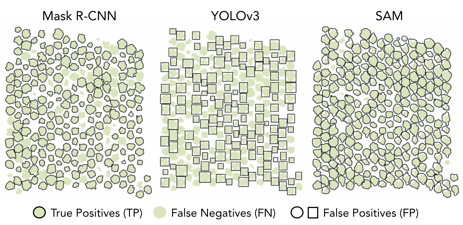
PROJECT: Machine Learning and Object Detection. One technical avenue my group has been participating in continues work from an earlier breakthrough paper (Blaschke et al. 2014) describing object-based image analysis (OBIA). The OBIA method represented an analytical paradigm shift necessitated by the proliferation of high spatial resolution imagery. OBIA allows for deep multi-scale analysis of imagery yielding huge benefits in object detection. However, Deep Learning methods have recently advanced the object detection task, and my group is actively working on new DL methods for analyzing high resolution drone imagery. In Csillik et al. (2018) we develop a novel workflow for delineation of citrus trees from UAV images using a simple convolutional neural network (CNN) algorithm. In Jacygrad, et al. (2022) we used OBIA methods on multi-date UAV imagery to predict the growth and development of pistachio trees grown from rootstock seedlings. In Kelly et al. (2025), we continued this work and explored the utility of 3 CNN models to map orchard trees through the growing season. The image to the above shows some of the results.
ACTIVITY: Outreach. The Cooperative Extension Service was established in 1914 in partnership with the U.S. Department of Agriculture and Land Grant colleges. In California, Cooperative Extension is organized through the UC Division of Agriculture and Natural Resources, the division of the University of California system with a public mandate and the public trust to share research-based information with the public about healthy communities, nutrition, agricultural production and environmental stewardship. UC Berkeley was the first Land Grant college in California, and CNR currently has ~20 CE specialists. My outreach program involves creation, integration, and application of research-based technical knowledge for the benefit of the public, policy-makers, and land managers. I have developed an extension program at the intersection of technology and impactful outreach to translate my research into impact, and to help colleagues incorporate geospatial data, analytics, and tools in their work to make research impactful, data collection easier, communication more profound, land management more effective, and to reveal crucial patterns in landscapes and ecosystems.
PROJECT: Drone Imagery Collection and Analysis. UAS, or unmanned aerial systems, commonly referred to as drones, address common spatial, temporal and cost-related challenges associated with satellite-collected imagery, and they are revolutionizing the way we collect data about agricultural and natural resources. They are fast becoming standard scientific data collection tools. Since 2016 my IGIS team and I have built a new data and informatics framework around drone research. Projects include using UAV imagery to quantifying tree growth in orchards, map invasive weeds in agricultural fields, map water stress and fire damage to vegetation. We have been exploring the utility of drones to understand temporal dynamics in agricultural (Jacygrad et al. 2022) and natural (Easterday et al. 2019) settings. Colleagues and I collaborated on a comprehensive review of drone applications for wetlands, with particular emphasis on wetland monitoring and management objectives that are most served by UAVs, and what workflows were employed to analyze these data (Dronova et al. 2021). With support from the Chinese Academy of Sciences President’s International Visiting Scientist Fellowship, I worked with colleagues from the University of Peking to evaluate the performance of a very low-cost UAV-lidar system for forestry applications (Hu et al. 2020). DroneCamps are a great way to get up to speed on this important technology. Want help? Check out the IGIS Drone Services Center.
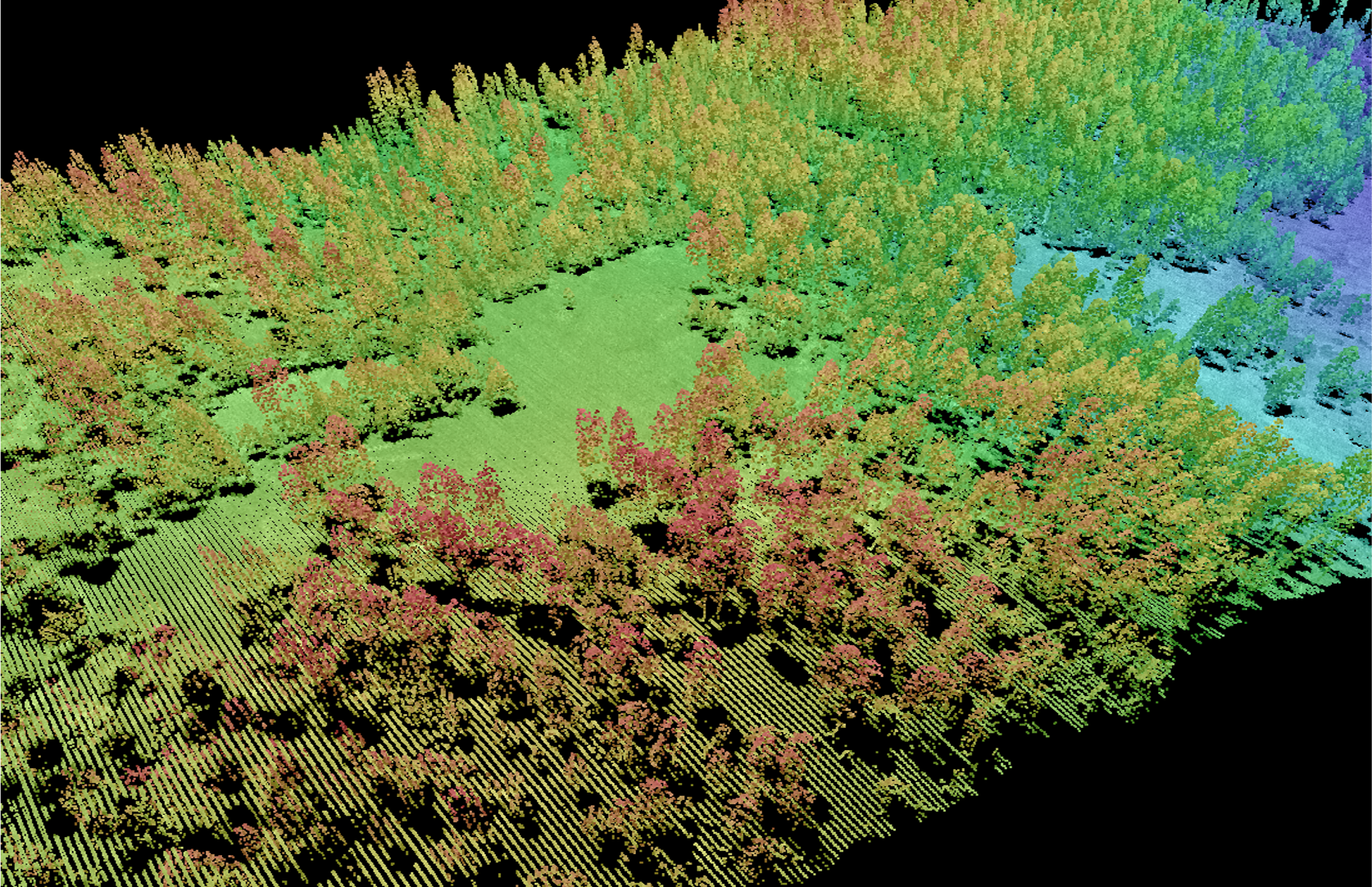
PROJECT: Forest Structure and Lidar. Mapping forest structure is critical for fire management, wildlife provisioning, water supply models, and other practical applications. I have been collaborating with the research group at the Chinese Academy of Science and the University of Peking to develop cutting-edge applications of LiDAR (light detection and ranging) for forest landscapes. For example, individual tree segmentation from LiDAR data is a critical early step in forest ecological research, and Yang et al. 2019 advances our earlier work on object detection and examines the effects of forest type, leaf area index, canopy cover, tree density, and tree height on the accuracy of tree segmentation methods. In Hu et al. (2019) we developed a novel metric to map fire-induced forest structural changes at the individual tree and clump of trees scales using pre- and post-fire LiDAR data. In Ma et al. (2023), we used LiDAR data from nearly 1.5 million trees in the Sierra Nevada mixed conifer forest during the 2012-2016 CA drought, and we found that trees in a structurally complex forest with tall neighboring trees experienced lower mortality rate, likely because of the lower solar radiation and less water demand through evapotranspiration. Our collective work using lidar led to the production of a perspective article (Guo et al. 2021), which reviews the ways in which lidar has revolutionized the way we observe and measure 3D vegetation structure.

RECENT GRAD STUDENT WORK: Remote Sensing of Vegetation Dynamics. Recent grads Chippie Kislik and Annie Taylor are leaders in remote sensing of vegetation dynamics for terrestrial and aquatic systems. Chippie’s papers (Kislik et al. 2022, Kislik et al. 2020) showcase remote sensing analysis (both UAV and satellite imagery) for monitoring benthic communities in California. Annie’s work includes critical Indigenous perspectives into spatial modeling and remote sensing approaches to examine fire and cultural plant stewardship in California's unique coastal grasslands. She partnered with the Amah Mutsun Tribal Band over several years focusing on three adjacent coastal grasslands with varying fire histories. In Taylor et al. (2023) she used a suite of modeling approaches with community science datasets to identify potential gathering areas for 10 culturally important plants in the Tribe’s stewardship area. In Taylor et al. (2024), she investigated how the abundance and occurrence of shrubs, cultural plants, and invasive plants differed across grasslands with differing fire histories. In Taylor et al. (2024) she used remote sensing analysis to quantify the fire impact on grassland plants and used interviews with tribal members to contextualize the results, and to investigate how cultural burning contrasts from typical Western fire management approaches in this region. This work is an innovative example of how interviews, field data, and satellite imagery can be combined to gain a deeper ecological and cultural understanding of fire in California's coastal grasslands.

PROJECT: The California Vegetation Type Mapping Project (VTM). The synthesis of historical and contemporary ecological data with modeling approaches improves our understanding of the complex response of species, communities, and landscapes to changing biophysical conditions through time and in space. The California Vegetation Type Mapping Project (VTM), led by Berkeley forester Albert Wieslander in 1920s, produced a record of California vegetation that covered nearly half of the state in exquisitely detailed maps and plots. Efforts in my lab to digitize and share these data began nearly two decades ago and have contributed to several important research avenues in which scholars, including me, have compared the historic VTM data with contemporary records of forest structure in California. In a high-profile paper in PNAS (McIntyre et al. 2015) we used the VTM data to show a demographic shift in forest structure over the last century toward smaller trees and at the expense of larger trees. We followed up that work by examining the role of land management and ownership on forest change (Easterday et al. 2018), and in another paper (Easterday et al. 2016), we investigated the effects of human urban development on oak species in California by modeling historical patterns of richness for eight oak tree species the VTM collection. While the vtm.berkeley.edu website is no longer supported, the overall VTM project is part of a larger collaborative effort to build open data frameworks for understanding a changing California. I have summarized lessons learned, examples, and best practices for digitizing and sharing historical ecological data in two papers (Kelly et al. 2016, 2017).
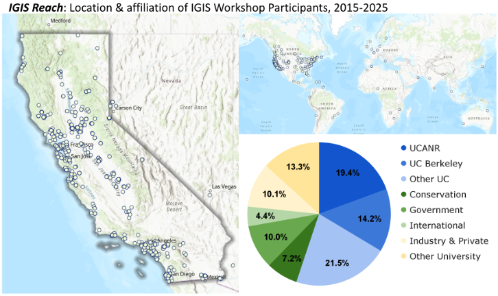
ACTIVITY: Technology Training. Want to learn more about spatial data science? IGIS offers a series of focused workshops targeted to university employees, local and federal government, conservation organizations, industry and non-profits, and the public. These workshops (both in person and virtual) cover many aspects of GIS, remote sensing, field data gathering, webmaps and apps, and have served over 3,400 people in California and around the world. Many of our participants come from the UCs, but others come from conservation, government and industry. More details are at our website. Accompanying our workshop program, we continue to develop our online resources including new video tutorials on using GIS software, workshop recordings, blog, and new and updated application-specific “Tech Notes”, which provide detailed tutorials on how to apply tools to real world scenarios. Check it all out at the IGIS website.
More Information: My CV / my Google Scholar page / my Research Gate page.