Mapping US Energy Futures
/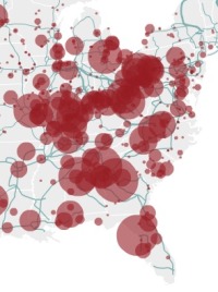 19th & 20th century power: coal plants in the eastern US with existing power gridFrom NPR: these new maps showing the US energy grid, a "complex network of independently owned and operated power plants and transmission lines. Aging infrastructure, combined with a rise in domestic electricity consumption, has forced experts to critically examine the status and health of the nation's electrical systems." This site has maps of existing power sources (coal, nuclear, gas, hydro and oil), and potential for new alternatives (wind and solar - no bio). What new infrastructure will be needed to bring wind and solar power from high production areas to the rest of the country?