A new tool for finding old maps: USGS topoView
/Get your topo maps!
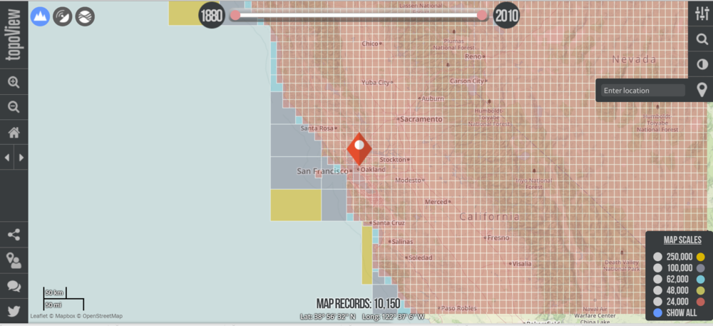
The USGS recently unvieled a new, extremely easy and enviably sleek web mapping interface to search and download nearly 178,000 topographical maps, dating from 1880 to 2010.
mapping for a changing california
Welcome to the Kellylab blog! We post fun facts and things that catch our eye. Occasionally I wax lyrically about a topic of interest.
Get your topo maps!
The USGS recently unvieled a new, extremely easy and enviably sleek web mapping interface to search and download nearly 178,000 topographical maps, dating from 1880 to 2010.
 SRTM 3 Arc-Second (approx. 90m)
  SRTM 1 Arc-Second (approx. 30m)
 Landsat 7 December 17, 2000
Just in time for class on topography and rasters tomorrow: new high res shuttle DEM data is being released for Africa. The image above shows the Niger River Delta in 90m res, 30m res, and landsat.
From the press release: In Africa, accurate elevation (topographic) data are vital for pursuing a variety of climate-related studies that include modeling predicted wildlife habitat change; promoting public health in the form of warning systems for geography and climate-related diseases (e.g. malaria, dengue fever, Rift Valley fever); and monitoring sea level rise in critical deltas and population centers, to name just a few of many possible applications of elevation data.
On September 23, the National Aeronautics and Space Administration (NASA), the National Geospatial-Intelligence Agency (NGA), and the U.S. Geological Survey (USGS, a bureau of the U.S. Department of the Interior) released a collection of higher-resolution (more detailed) elevation datasets for Africa. The datasets were released following the President’s commitment at the United Nations to provide assistance for global efforts to combat climate change. The broad availability of more detailed elevation data across most of the African continent through the Shuttle Radar Topography Mission (SRTM) will improve baseline information that is crucial to investigating the impacts of climate change on African communities.
Enhanced elevation datasets covering remaining continents and regions will be made available within one year, with the next release of data focusing on Latin America and the Caribbean region. Until now, elevation data for the continent of Africa were freely available to the public only at 90-meter resolution. The datasets being released today and during the course of the next year resolve to 30-meters and will be used worldwide to improve environmental monitoring, climate change research, and local decision support. These SRTM-derived data, which have been extensively reviewed by relevant government agencies and deemed suitable for public release, are being made available via a user-friendly interface on USGS’s Earth Explorer website.
Nice slider comparing the 90m to the 30m data here.
NextMap's World 30 DSM is ready. Pricing starts at as low as 1 cent per km2.
 ASTER, with some problematic gaps...
 NEXTMap, without the gaps
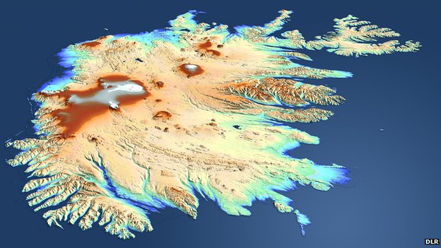 TanDEM's view of Iceland: The country was beyond the sight of the shuttle topography mission in 2000We talked about TanDEM before, after launch. The German satellite radar twins - TanDEM-X and TerraSAR-X - are a year through their quest to make the most precise, seamless map of varying height on Earth.
They've now acquired data across the entire globe at least once. However, some tricky sampling areas, such as tall mountains and thick forests, will require several passes and so we don't expect to see a fully finished product before 2014.
As compared with the Shuttle product at best spatial resolution of 30m by 30m, and a vertical resolution that varies from 16m to 10m, the intention of the TanDEM mission is to go down to a spatial resolution of 12m by 12m and a vertical resolution of 2m. Airbone lidars can achieve much better precision, but these maps are necessarily regional in extent - they will cover only relatively small areas. The purpose of TanDEM is to build a world DEM that is single-source and has "no joins".
Report from the BBC here.
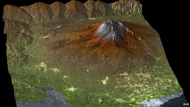 The TanDEM Digital Elevation Model of Mount Etna, Sicily, Italy
NASA and Japan’s Ministry of Economy, Trade and Industry released yesterday a new and improved version of their ASTER global digital elevation model (GDEM) which was first released in 2009. This new and improved version offers improved spatial resolution, horizontal and vertical accuracies, and more realistic coverage over water bodies with the ability to identify water bodies as small as 1 km in diameter. This new data is now comparable to NASA's Shuttle Radar Topography Mission DEM data. The new ASTER GDEM covers 99 percent of the Earth’s landmass at 30 meter spatial resolution. It is free to download here. For information on the improved version see here and here.
 ASTER DEM of Grand Canyon National Park in northern Arizona July 14, 2011 from space.com. Credit: NASA/GSFC/METI/ERSDAC/JAROS, and U.S./Japan ASTER Science Team
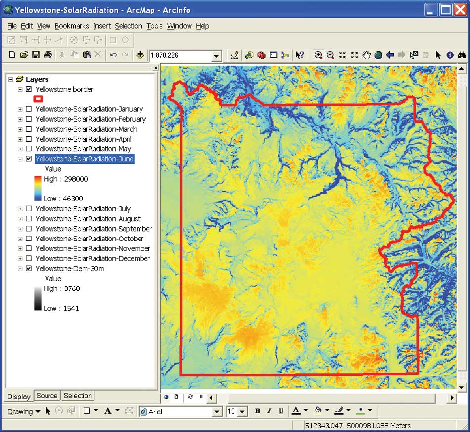 June solar radiation in YellowstoneA nice case study of detailed solar radiation modeling/mapping for Yellowstone National Park. All using existing ESRI spatial analyst tools.
Scientists at the National Aeronautics and Space Administration (NASA) Ames Research Center, including our buddy Chris Potter, the Yellowstone Ecological Research Center (YERC), the Creekside Center for Earth Observation (CCEO), and Esri have created 30-meter solar and temperature distribution maps in mountainous Yellowstone National Forest using tools in the ArcGIS Spatial Analyst extension. These products support ecological management in Yellowstone.
An overview of ESRI's Solar Radiation Tools can be found here. Go forth and insolate.

German based TanDEM-X and TerraSAR-X satellites, launched in 2007 and 2010 respectively, begin their tandem orbit flight to create a new global DEM product of the Earth's surface to be available in 2014.
The TanDEM mission seeks to produce a global DEM at 12 meter sp
atial resolution with a relative vertical accuracy of less than two meters. With this kind of specification "'the TanDEM dataset will replace SRTM'". The US Shuttle Radar Topography Mission (SRTM) of 2000 is one of the best-known, near-global, space-borne DEM prior to TanDEM. Its best product has a 30 meter spatial resolution, and a vertical accuracy that varies from 16m to 10m.
Airborne laser instruments such as Lidar can achieve finer spatial resolution and vertical accuracy but their products are regional - they are not seamless maps of the whole Earth as TanDEM will be able to achieve. For more read the full story here.
 Comparison between SRTM and TanDEM-XFrom the BBC: The TanDEM-X satellite has blasted into orbit on a mission to acquire the most precise 3D map of the Earth's surface.
The German radar spacecraft will fly in formation with an identical platform called TerraSAR-X launched in 2007. Together, the pair will measure the variation in height across the globe to an accuracy of better than two metres.
With the TanDEM mission, the intention is to go down to a vertical resolution of two metres, with a spatial resolution of 12m by 12m. Airborne laser instruments (lidars) can do better than this but their DEMs are only regional. To achieve the TanDEM level of detail on all 150 million sq km of the Earth's land surface will require three years of operation.
This was recommended to me recently by Orien; he is using it to create topographic indices to use as ancillary data in an object-based classification of palustrine wetlands in the foothills of the Sierra Nevada. These wetland sites are terrifically important for rails, and mapping them efficiently is a challenge. Topographic information is proving useful in the classification, and Orien used this software rather than the ArcGIS hydro modeler suite.
From David Tarboton at Utah State: Terrain Analysis Using Digital Elevation Models (TauDEM) is a set of tools for the analysis of terrain using digital elevation models. TauDEM currently provides numerous capabilities that expand on the ESRI suite including (more listed on website):