Very high res urban mapping: research reported at the Berkeley BEARS 2011 EECS Annual Research Symposium
/At the recent February 17th Berkeley BEARS 2011: Electrical Engineering and Computer Sciences (EECS) Annual Research Symposium some interesting new developments and research in the world of information technology were showcased. The first section of the symposium hosted four talks about current and future research at UC Berkeley in IT focusing on large scale data mining, aggregation and analysis; artificial intelligence and language processing; augmenting reality with virtual and mobile systems of information display and collection; and sensor/communication nanotechnology.
Most notable in application to GIS, although far off, it was mentioned that work is underway to try to miniaturize the lasers in LiDAR sensors to the scale of inserting them into mobile phones to enable collective 3D ground mapping of urban areas from mobile users and for placement in building materials to monitor building occupants/conditions. More current was the talk from Avideh Zakhor about work in the VIP lab on combining data from mobile ground based sensors, similar to those used to create Google street view, with aerial photos to create 3D urban models at varying resolutions (Read more) (Video). Also in development is putting the same technology that is used to create Google street view of exterior streets in the interiors of buildings. This enables the creation of 3D interior building models and photorealistic walk through environments of interior spaces. This may have many implications in emergency preparedness/management, design, and marketing (Read more) (Example image below).
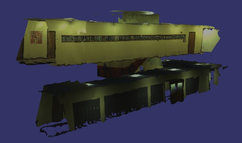 Source: Image from Avideh Zakhor homepage: http://www-video.eecs.berkeley.edu/~avz/
Check out the BEARS 2011 website here for more information and for video recordings of the talks to be up soon.
For more information on the individual presenters: Ion Stoica, Dan Klein, Avideh Zakhor, Kristofer Pister, and Jan Rabaey.