Lidar + OPALs geolunch and workshop next week!
/ Full waveform lidarOur colleague Bernhard Hofle from the University of Heidelberg will be here next week as part of an international exchange project: Airborne Laser Scanning for 3D Vegetation Characterization: Set-up of an International Signature Database. Bernhard is interested in Open Source GI and Spatial Database Management Systems, Object-based image and point cloud analysis, radiometric calibration of full-waveform airborne LiDAR data, and other topics.
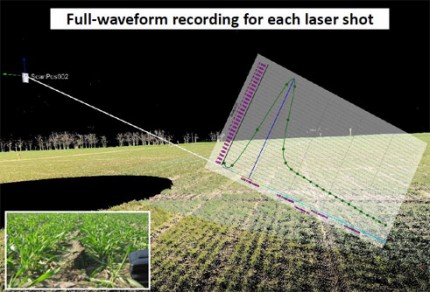
Bernhard is part of a group that now has one of the first Terrestrial Laser Scanning (TLS) systems worldwide with full-waveform recording capability (upgraded Riegl VZ-400). Deeper understanding and substantially improved analysis of the laser shot backscatter of natural objects by having direct access to full-waveform signatures and physical observables are expected. The unique system will be applied in new research projects dealing with the extraction of 3D geoinformation in e.g. precision farming, geoarchaelogy, geomorphology and forestry. Furthermore, an extensive web-based database of reference signatures for known objects will be developed based on calibrated waveform features derived by TLS.
He is a leader in analysis of discrete and waveform lidar data in urban and forest applications and one of the developers of the cool OPALS lidar software. He'll be giving a geolunch and a workshop afterwards on the software. The geolunch is 1-2, then we will stick around and learn about OPALS.