Those crowded skies: Flight maps and delays
/ real time map of flights from planefinder.netYou've probably seen the frequently-cited "Misery Map" (D3 behind the scenes) showing how the Thanksgiving storm has blown many a tight travel plan off schedule.
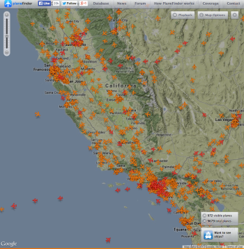
Here is another cool one: real-time map of all the flights in the air. It looks crowded!
Happy and safe travels everyone.
FlightAware.com has created the Misery Map, a real-time weather and flight data visualization tool that overlays Nexrad radar imagery on a map of the country, with red-green graphs showing the pain at major airports.
Read more at http://www.flyingmag.com/technique/flight-planning/flightaware-misery-map-tracks-travel-delays#tXwGX8OjSo5QhDUk.99
Read more at http://www.flyingmag.com/technique/flight-planning/flightaware-misery-map-tracks-travel-delays#tXwGX8OjSo5QhDUk.99