American fire burns into SNAMP sites
/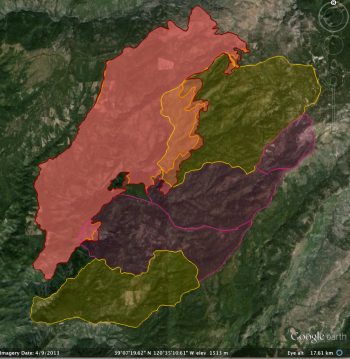 American fire perimeter (red) as of 8-20-13The American fire is burning into our SNAMP study areas as of yesterday. Here is a snapshot of our study site and the fire perimeter (red) as of today (8-19-13 perimeter in orange). SNAMP control (yellow) and treatment (purple) watersheds are shown.
All SNAMP field crews are safely evacuated, with almost all field work completed for the year.
From the Incident Report: "The American Fire burning in heavy fuels on extreme slopes about 10 air miles northeast of the community of Foresthill, California, and eight air miles south of Interstate 80 has grown to 14,765 acres. While the fire is predominantly  SimTable animation of American fire spread - modeled thru 8-14 I am guessingburning on the Tahoe National Forest within the North Fork of the Middle Fork American River drainage, there is a potential, given changes in weather or fire behavior, for the fire to threaten areas near Foresthill.
Active fire behavior continues on the eastern and southern flanks of the fire. Overnight, crews continued to build hand and dozer line to contain the active fire while evaluating future containment options. Firefighters will mop up and patrol containment line along Deadwood Road and Foresthill Divide Road south to the dozer line. Indirect line construction and mop up will continue down Deadwood Ridge. On the east side near Antoine, Manila and Screwauger Canyons,  American fire as of 8-20-13 from ESRI onlinedirect and indirect line construction will continue, with support of retardant drops.
Active fire behavior and roll out of burning material continue to be of concern, and will be closely monitored. Strong, erratic outflow winds and lightning may occur today, as the National Weather Service’s Red Flag Warning remains in effect until 11 p.m. Wednesday.
Active fire behavior in very steep, inaccessible terrain makes preparation of contingency lines critical. Indirect attack is the safest way to manage fire in areas of steep and difficult terrain."
In the images to the left, both from ESRI online, there are a number of thermal hotposts in SNAMP territory 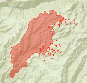 American fire as of 8-21-13 from ESRI online(the red dots outside of the fire boundary) that were detected as of 10:30am 8-20-13 (upper image). As of 8-21-13 the MODIS hotspots indicate possible fire movement along Foresthill Rd to the east, and into the SNAMP control study area.
Some resources:
- Incident Report: http://www.inciweb.org/incident/3624/
- SimTable Report: http://apps.simtable.com/fireProgression/outputTemp/CA-TNF-HU11_%20american.html
- ESRI Online report: http://www.arcgis.com/explorer/?open=11487c248b3a407cb6fd446ce8ef73d8
We will keep you posted.
For more on the SNAMP project see: http://snamp.cnr.berkeley.edu/
This was originally posted on /.