Speaking of Google Earth…
/A couple of newsworthy items concerning our neighbor to the south (Not including Karin's "Google Gate Bridge" idea): 1. Google Earth gets assisted by new satellite; 2. Google Earth used in Fossett search.
mapping for a changing california
Welcome to the Kellylab blog! We post fun facts and things that catch our eye. Occasionally I wax lyrically about a topic of interest.
The USGS earthquake site that we all love and was the inspiration for OakMapper has reorganized a bit, and has some nice global quake maps. See that we on the Hayward fault are not alone: USGS Earthquake Hazards Program
.
Y'all might be interested in this. Hell, I might even go. Via the geowanking list,
A quick reminder: WhereCamp is being held June 2-3 at the Yahoo! Sunnyvale campus. There'll be sessions and whatnot. You might also consider it a Geowanking list meet-up of sorts. Description: WhereCamp un-conference. Free. A hugely energetic overlap of diverse interests ranging from newbies, web 2.0 and mobile developers, social place hackers and artists to grad students, geographers, earth scientists and people focused on humanitarian and environmental efforts. Wiki: http://wherecamp.pbwiki.com/WhereCampSF Directions: http://docs.yahoo.com/info/address/ Registered Attendees: http://wherecamp.pbwiki.com/WhereCampSFRegistrants and: http://upcoming.yahoo.com/event/170065/ See you there! -- Joshua Schachter http://del.icio.us/joshua http://joshua.schachter.org/
After I saw this: I created a specialized, simplified, hacked up version on giif, that is pretty useful. the simplest way to see its use is by going here (ken-ichi, i'm leaving the link text == href intentionally): http://firecenter.berkeley.edu/proxy/geoservice.py/geocode/2134%20Allston%20Way,%20Berkeley,%20CA,%2094704 that is the lat/lon of CanCun Burritos. If you prefer your burritos in UTM, you can request by appending ?epsg=26910 to the end: http://firecenter.berkeley.edu/proxy/geoservice.py/geocode/2134%20Allston%20Way,%20Berkeley,%20CA,%2094704?epsg=26910 or any valid EPSG code that GDAL on giifweb will recognize. (if you dont know what EPSG is, you should consider freeing yourself from your dependency on ESRI products.) likewise, reverse geocoding: http://firecenter.berkeley.edu/proxy/geoservice.py/reverse_geocode/-122.2584/37.8675 and it may return you a list of info. depending on wether geonames.org can reverse_geocode your points. again that assumes lat/lon, you can specify an EPSG code by appening ?epsg=26910 to the end of the query. it's useful to have this built into a webGIS. where,perhaps, the user enters an address and you move the map to that lat/lon. the script will generate an example if you browse to: http://firecenter.berkeley.edu/proxy/geoservice.py/example if you enter an address and an EPSG, it should alert the lat/lon, and then try to reverse_geocode and alert that derived place. if you view the source on that page, you can see how to include the necessary javascript: and if you browse to that url, you'll see the lovely javascript that is generated. Since AJAX is used, you'll either need to download the source to somewhere that has GDAL and web.py installed, or be on giifweb. to use the javascript, you need to attach an event to call the geocode() javascript function:
document.getElementById('button').onclick = function(){
geocode(document.getElementById('address').value, 4326);
};
where geocode() generates a url and makes the AJAX request to server to do the geocoding for you. again, the 4326 is the default, optional EPSG, to use other projections, just put that as the 2nd argument. then, when the result returns from the server, it geocode.callback is called with the resulting JSON: so you can define your own callback like: geocode.callback = function(result){ // do something with the result. document.getElementById('x').value = result.x document.getElementById('y').value = result.y }; where result.x and result.y correspond to the x and y properties here it's simpler than it sounds, best to view and read the source of the example. or better yet, just make the python script print itself. in all places in this post where it says firecenter.berkeley.edu, you can substitute giif.cnr.berkeley.edu or giifweb.cnr.berkeley.edu, and it will work as it should. and you will have to do this if you use the javascript/AJAX because of cross-domain issues. sorry i dont know how to format html properly on this blag.
Google Earth has begun mapping the Darfur crisis.
Google, Yahoo!, and Microsoft have all announced that they now support the GeoRSS standard. This standard allows RSS feeds to provide a location that corresponds with the story in the feed.
The International Diabetes Federation is sponsoring a worldwide geocaching event to promote diabetes awareness. 20,000 'travel bugs' are moving around the world in support of the UN resolution to promote diabetes awareness, prevention, and care. IDF’s goal to reach 1 billion people with awareness messaging about diabetes care and prevention.
Check out KQED's beautiful website: QUEST
.
Here are some nice examples of "storymapping" projects given to me by SNAMP collaborators. Check out: Story Mapping Project, Saving the Sierra; and Community Walk.
Over the past few months, I've run into some cool Google Maps mashups. Check and see.
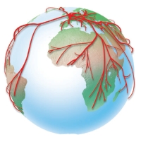 Several researchers at Stanford have written some software for visualizing flow maps. There pictures are very pretty, and, I think, good data vis. The map above shows the top ten states providing migrants to NY and CA. Here's their abstract:
Cartographers have long used flow maps to show the movement of objects from one location to another, such as the number of people in a migration, the amount of goods being traded, or the number of packets in a network. The advantage of flow maps is that they reduce visual clutter by merging edges. Most flow maps are drawn by hand and there are few computer algorithms available. We present a method for generating flow maps using hierarchical clustering given a set of nodes, positions, and flow data between the nodes. Our techniques are inspired by graph layout algorithms that minimize edge crossings and distort node positions while maintaining their relative position to one another. We demonstrate our technique by producing flow maps for network traffic, census data, and trade data.