Researching why animals move across the land

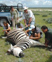
Collaring a zebraA very nice article about Wayne Getz's research in Africa: spatial ecology, epidemiology, conservation and citizen science. From Breakthroughs Magazine

In this article he talks about his evolution as a scientist from mathematician to geo-nerd. The article states: At the core of Getz’s work is how and why animals move across the land. People have sought answers to these questions for time immemorial - at first to improve success in the hunt and harvest, and much later to understand animals in and of themselves. His approach combines a mathematician’s genius for analysis with hands-on wildlife research. This unique perspective is revealing that animal travel patterns can provide a great number of insights into animal behavior, ecology, and epidemiology.

And now the GIS part: In recent years, the advent of global positioning system technologies, coupled with expanded telecommunications networks, have added up to a revolution in animal tracking. The modern version of the radio collar can map an animal’s position to within a couple of meters every few minutes, upload the stored data automatically to a satellite or cell phone network, and allow biologists to track the beast from afar for many weeks. 

Also read about his work in education and social justice in South Africa. Cool stuff. Check it.

The future is already here – it's just not evenly distributed. Or maybe it is.

William Gibson (yes that one) in the NYTimes Opinion page, writes about Google, and the way it has changed how we interact with information and the world. It is a really interesting article touching on human choice, surveillance, and the catch-up game the law plays with technology. This visionary author of Neuromancer says "Science fiction never imagined Google..." and goes on to describe its omipresence, our ready participation in this process, and our discomfort at the result. He is a fantastic writer. Check it:

Google is not ours. Which feels confusing, because we are its unpaid content-providers, in one way or another. We generate product for Google, our every search a minuscule contribution. Google is made of us, a sort of coral reef of human minds and their products.

Wow. Here is another example of his engaging and illuminating prose:

Jeremy Bentham’s Panopticon* prison design is a perennial metaphor in discussions of digital surveillance and data mining, but it doesn’t really suit an entity like Google. Bentham’s all-seeing eye looks down from a central viewpoint, the gaze of a Victorian warder. In Google, we are at once the surveilled and the individual retinal cells of the surveillant, however many millions of us, constantly if unconsciously participatory. We are part of a post-geographical, post-national super-state, one that handily says no to China. Or yes, depending on profit considerations and strategy.

The title of this post comes from his oft-cited quote in 2003 in The Economist.

*About the Panopticon from wikipedia: The Panopticon is a type of prison building designed by English philosopher and social theorist Jeremy Bentham in 1785. The concept of the design is to allow an observer to observe (-opticon) all (pan-) prisoners without the incarcerated being able to tell whether they are being watched, thereby conveying what one architect has called the "sentiment of an invisible omniscience."
GIF Open House Today!

Thursday, September 2, 1-3 PM 

111 Mulford Hall

Check out new equipment and find out how mapping technology can enhance your research! 

The Geospatial Innovation Facility (http://gif.berkeley.edu) will be hosting an open house on Thursday, September 2 at 1PM.  Meet UC students, faculty, and staff who are interested in geospatial applications, and learn how the GIF can help you to utilize technologies including GIS, GPS, Remote Sensing, WebGIS, and 3D Visualization. 

Root beer floats will be available while supplies last!

Welcome to Fall 2010 with this stunner of a pic from NASA

Mataiva Atoll, Tuamotu Archipelago, South Pacific OceanFrom the NASA Earth Observatory Image of the Day: The Tuamotu Archipelago is part of French Polynesia, and forms the largest chain of atolls in the world. This astronaut photograph features Mataiva Atoll, the westernmost atoll of the Tuamotu chain. Mataiva Atoll is notable in that its central lagoon includes a network of ridges (white, image center) and small basins formed from eroded coral reefs. Mataiva means “nine eyes” in Tuamotuan, an allusion to nine narrow channels on the south-central portion of the island. The atoll is sparsely populated, with only a single village—Pahua—located on either side of the only pass providing constant connection between the shallow (light blue) water of the lagoon and the deeper (dark blue) adjacent Pacific Ocean. Much of the 10-kilometer- (6-mile-) long atoll is covered with forest (greenish brown). Vanilla and copra (dried coconut) are major exports from the atoll, but tourism is becoming a larger part of the economy.

This is not a satellite image, but a photograph taken by the Expedition 24 crew from the International Space Station (I think) on August 13, 2010, with a Nikon D2Xs digital camera using a 400 mm lens. More here.


Everyone should listen to today's Fresh Air interview

Not directly map related, but might be. As I sit here with three screens, email open, working on multiple projects, including upcoming semester's lectures, AND listening to today's Fresh Air, I am struck dumb. In this interview, in which dear old Terry Gross reveals her late nite email addiction (et tu Terry?), the guest Matt Richtel (NTimes) reveals the answers to the following questions (and many more): Why is email addicting? Are there downsides to our constant focus on multiple influxes of infomation? What are the psycological and neurological underpinnings to this madness? The answers involve dopamine, stress hormones, declining capacity to concentrate and create, and a whole lot of scary.

Are there parallels or lessons for us in our deluge of map-related technology and data? Yikes!

USGS seeks input for new carbon accounting plan

A draft methodology is proposed in response to requirements by the Energy Independence and Security Act of 2007 to assess ecosystems for carbon stocks, carbon sequestration, and greenhouse-gas fluxes. The assessment will be conducted to estimate capacities of ecosystems to increase carbon sequestration and reduce greenhouse-gas fluxes, in contexts of land-use, land-cover, and land-management scenarios as well as other controlling processes, such as climate change and wildland fires. Results of the assessment will be useful for evaluating a range of choices for formulating mitigation strategies and other land management policies.

GIScience added to federal list of STEM disciplines

ICE announces expanded list of science, technology, engineering, and math degree programs Qualifies eligible graduates to extend their post-graduate training

WASHINGTON-U.S. Immigration and Customs Enforcement (ICE) today published an expanded list of science, technology, engineering, and math (STEM) degree programs that qualify eligible graduates on student visas for an Optional Practical Training (OPT) extension-an important step forward in the Obama administration's continued commitment to fixing our broken immigration system and expanding access to the nation's pool of talented high skilled graduates in the science and technology fields.

The announcement follows President Obama's recent remarks in El Paso, Texas, where he reiterated his strong support for new policies that embrace talented students from other countries, who enrich the nation by working in science and technology jobs and fueling innovation in their chosen fields here in the United States, as a part of comprehensive reform. 

By expanding the list of STEM degrees to include such fields as Neuroscience, Medical Informatics, Pharmaceutics and Drug Design, Mathematics and Computer Science, the Obama administration is helping to address shortages in certain high tech sectors of talented scientists and technology experts-permitting highly skilled foreign graduates who wish to work in their field of study upon graduation and extend their post-graduate training in the United States.

Under the OPT program, foreign students who graduate from U.S. colleges and universities are able to remain in the U.S. and receive training through work experience for up to 12 months. Students who graduate with one of the newly-expanded STEM degrees can remain for an additional 17 months on an OPT STEM extension. More here.

Maps as Media: Map making in the 21st century

Today's "On the Media" radio show included a great discussion of maps and map making in the Google era. Largely a synopsis of this article in the Washington Monthly by John Gravois, the radio piece, with John Gravois, touched on the decline of the National Map and the rise of the Google Map paradigm, and the consequences of this change: how does Google name features that are in dispute? what do maps mean as their lineage changes from government to corporation? how do the political nuances of national maps change as Google becomes the global standard for map making? do we need a new term for these increasingly community based collections of spatially tagged conversations? It was a really interesting piece, and I recommend it. Good listening.

If San Francisco Crime were Elevation

From Doug McCune's blog, the motto of which is: "I was Web 2.0 before your grandma was Web 2.0" which is kinda cute, gotta admit. Not that my grandma was ever anything close to that, she was a great baker though.

Anyway - he says: "I’ve been playing with different ways of representing data and I decided to venture into 3D representations. I’ve used a full year of crime data for San Francisco from 2009 to create these maps. The full dataset can be download from the city’s DataSF website." These are really rad and interesting.

He's chosen a solar illumination from the east, as it would be during sunrise.

He has a disclaimer: "These maps were generated from real data, but please don’t take them as being accurate. The data was aggregated geographically and artistically rendered. This is meant more as an art piece than an informative visualization." which is valid, but these are still really nice.


Global 12m DEM with TanDEM-X satellite

Comparison between SRTM and TanDEM-XFrom the BBC: The TanDEM-X satellite has blasted into orbit on a mission to acquire the most precise 3D map of the Earth's surface.

The German radar spacecraft will fly in formation with an identical platform called TerraSAR-X launched in 2007.  Together, the pair will measure the variation in height across the globe to an accuracy of better than two metres.

With the TanDEM mission, the intention is to go down to a vertical resolution of two metres, with a spatial resolution of 12m by 12m. Airborne laser instruments (lidars) can do better than this but their DEMs are only regional. To achieve the TanDEM level of detail on all 150 million sq km of the Earth's land surface will require three years of operation.

Definiens Earth Science bought by Trimble

The new company will be called Trimble Geospatial Munich, and maintain the same staff, and the Centers of Excellence Program.  From the Open Letter:

"Definiens’ earth sciences business, including the eCognition suite of products, was acquired on June 10, 2010 by Trimble. The eCognition team has now transferred to Trimble, and the business of delivering the most advanced geospatial analysis software will continue, uninterrupted.

This change represents a significant step forward for eCognition. Access to Trimble’s advanced technologies, expertise and global operations provides us with an exceptional opportunity to take eCognition to a new level. In time, the benefits of the synergies between Trimble and eCognition will become evident through the exciting new product and service innovations we deliver together.

It is also worth noting that the collaboration with Definiens does not end with this transaction. In fact, Definiens and Trimble have signed a co-development agreement to ensure that the core technology driving eCognition continues to evolve and improve, and that there is no pause in the development or release schedule for eCognition."

California Protected Areas Database (CPAD 1.5) released

The new California Protected Areas Database (CPAD 1.5) has just been released in geodatabase and shape file formats.  Please visit www.calands.org to download.  Updates and improvements to CPAD are described in the CPAD Manual also available on the CALands web site.

WHAT'S NEW IN CPAD 1.5: CPAD 1.5 includes many updates and corrections to federal and state lands in the Sierra Nevada region, as well as a thorough review of the San Joaquin Valley and Bay Area.  CPAD data is better aligned to parcels, and we have more accurately captured managing agencies.  Urban parks data has generally been significantly improved in CPAD 1.5, with many missing parks now included and boundaries and attributes made more accurate.

VIEW CPAD DATA ONLINE, REPORT ISSUES: For those who do not use GIS or prefer to view CPAD via the web, you can do so though a google map overlay at http://www.calands.org/review.php.  We welcome input from the CPAD user community to keep us informed about errors and updates in CPAD.  Please report errors by clicking on the "Report Error" button.

GET NOTIFIED WHEN CPAD IS UPDATED: We encourage you to receive CPAD updates.  You can do this by clicking on the "Receive Update Notification" link on the calands.org homepage.  We will not distribute any of your information or use your email outside of the CPAD mailing list.  Registering helps us better serve the CPAD user community.

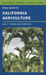
Hot of the Presses! Field Guide to California Agriculture

Anyone who travels California's byways sees the many faces of agriculture. A huge entwined business, farming and ranching are the state's dominant land use. Yet few Californians understand what animals and crops are raised or how agriculture reflects our relationship with nature. This fascinating and gorgeously illustrated field guide gathers essential information about agriculture and its environmental context, and answers the perennial question posed by California travelers: “What is that, and why is it growing here?” Paul F. Starrs's lively text explores the full range of the state's agriculture, deftly balancing agribusiness triumphalism with the pride of boutique producers, sketching meanwhile the darker shadows that can envelop California farming. Documented with diverse maps and Peter Goin's insightful photographs, this book captures the industry's energy and ingenuity and its wildly diverse iconography, from the mysteries of forbidden crops (like marijuana) to the majesties of scale in food production.

Check it.