ASPRS 2012 Wrap-up

ASPRS 2012, held in Sacramento California, had about 1,100 participants. I am back to being bullish about our organization, as I now recognize that ASPRS is the only place in geospatial sciences where members of government, industry, and academia can meet, discuss, and network in a meaningful way. I saw a number of great talks, met with some energetic and informative industry reps, and got to catch up with old friends. Some highlights: Wednesday's Keynote speaker was David Thau from Google Earth Engine whose talk "Terapixels for Everyone" was designed to showcase the ways in which the public's awareness of imagery, and their ability to interact with geospatial data, are increasing. He calls this phenomena (and GEE plays a big role here): "geo-literacy for all", and discussed new technologies for data/imagery acquisition, processing, and dissemination to a broad public(s) that can include policy makers, land managers, and scientists. USGS's Ken Hudnut was Thursday's Keynote, and he had a sobering message about California earthquakes, and the need (and use) of geospatial intelligence in disaster preparedness.

Berkeley was well represented: Kevin and Brian from the GIF gave a great workshop on open source web, Kevin presented new developments in cal-adapt, Lisa and Iryna presented chapters from their respective dissertations, both relating to wetlands, and our SNAMP lidar session with Sam, Marek, and Feng (with Wenkai and Jacob from UCMerced) was just great!

So, what is in the future for remote sensing/geospatial analysis as told at ASPRS 2012? Here are some highlights:

  • Cloud computing, massive datasets, data/imagery fusion are everywhere, but principles in basic photogrammetry should still comes into play;
  • We saw neat examples of scientific visualization, including smooth rendering across scales, fast transformations, and immersive web;
  • Evolving, scaleable algorithms for regional or global classification and/or change detection; for real-time results rendering with interactive (on-the-fly) algorithm parameter adjustment; and often involving open source, machine learning;
  • Geospatial data and analysis are heavily, but inconsistently, deployed throughout the US for disaster response;
  • Landsat 8 goes up in January (party anyone?) and USGS/NASA are looking for other novel parterships to extend the Landsat lifespan beyond that;
  • Lidar is still big: with new deployable and cheaper sensors like FLASH lidar on the one hand, and increasing point density on the other;
  • Obia, obia, obia! We organized a nice series of obia talks, and saw some great presentations on accuracy, lidar+optical fusion, object movements; but thorny issues about segmentation accuracy and object ontology remain; 
  • Public interaction with imagery and data are critical. The Public can be a broader scientific community, or a an informed and engaged community who can presumably use these types of data to support public policy engagement, disaster preparedness and response.

AAG 2012 Wrap-up

NY skyline from Tim DeChant's blogAAG was a moderately large conference (just under 9,000) this year, held in mid-town NY. It was a brief trip for me, but I did go to some great talks across RS, GIScience, cartography, and VGI. I also went to a very productive OpenGeoSuite workshop hosted by OpenGeo. Some brief highights from the conference: Muki Hacklay discussed participation inequities in VGI: when you mine geoweb data, you are mining outliers, not society; there are biases in gender, education, age and enthusiasm. Agent-based modeling is still hot, and still improving. I saw some great talks in ABM for understanding land use change. Peter Deadman showed how new markets in a hot crop (like Acai) can transform a region quite quickly. Landsat 8 will likely be launched in early 2013, but further missions are less certain. My talk was in a historical ecology session, and Qinghua Guo and I highlighted some of the new modeled results of historic oak diversity in California using VTM data and Maxent.

Saturday evening I had the great pleasure of being locked in after hours at the NY Public Library for a session on historic maps. David Rumsey, with Humphrey Southall (University of Portsmouth) and Petr Pridal (Moravian Library) led a presentation introducing a new website: oldmapsonline.org. The website's goal is to provide a clearer way to find old maps, and provide them with a stable digital reference. 

New Map Tool and Widgets: What’s Your Coastal Flood Risk?

This new interactive website SurgingSeas, a project of Climate Central, lets you see the combined coastal flood threat from sea level rise and storm surge, town by town and city by city from coast to coast. Type in your Zip code or the name of your community, choose a water level anywhere from 1 to 10 feet above the current high-tide line, and you can see what areas might be at risk of flooding from water that high. You can also go to any one of 55 tide gauges we studied around the country, and see the odds we’ve calculated for how soon flood waters may reach different elevations as the sea continues to rise. There are gauges close to most major coastal cities. If you want to embed the map in your own blog or website, there’s a widget for that, and you can make any view your default — not just the national one. - Michael D. Lemonick

Minor in GIS @ Berkeley

Great news!! The Minor in Geospatial Information Science and Technology has been approved in 2 departments at UC Berkeley!  Environmental Science, Policy and Management (in the College of Natural Resources), and the Department of City and Regional Planning in the College of Environmental Design now have Minors in Geospatial Information Science and Technology and includes courses across campus. These programs would serve students in geography and other social sciences, archeology, environmental science, policy and management, city and regional planning, humanities, architecture, landscape architecture and environmental planning, civil and environmental engineering, public policy, and environmental public health. The Minor will help prepare graduates for a workplace in public and private sectors with increasing need for geospatial expertise. In 2010, the Dept. of Labor's Employment and Training Administration (ETA) tagged Geospatial Technologies as a "High Growth Industry". The Minor is open to all majors at UC Berkeley.

Please see GIS@Berkeley for more info.

New OSGeo-Live GIS software collection released

OSGeo-Live is a self-contained bootable DVD, USB flash drive and Virtual Machine based upon Ubuntu Linux that is pre-configured with a wide variety of robust open source geospatial software. The applications can be trialled without installing anything on your computer, simply by booting the computer from the DVD or USB drive. The lightening overview introduces all these applications, and hence provides a comprehensive introduction to the breadth of Geospatial Open Source.

http://live.osgeo.org

Highlights
50 Quality Geospatial Open Source applications installed and pre-configured
Quality free world maps and geodata
One page overviews and quick start guides for all applications
Overviews of key OGC standards
Translations for Greek, German, Polish, Spanish and Japanese

Contents

Browser Clients

  • OpenLayers - Browser GIS Client
  • Geomajas - Browser GIS Client
  • Mapbender - Geoportal Framework
  • MapFish - Web Mapping Framework
  • GeoMoose - Web GIS Portal

Crisis Management

  • Sahana Eden - Disaster management
  • Ushahidi - Mapping and Timeline for events

Databases

  • PostGIS - Spatial Database
  • SpatiaLite - Lightweight Database
  • Rasdaman - Multi-Dimensional Raster Database
  • pgRouting - Routing for PostGIS


Desktop GIS

  • Quantum GIS (QGIS)
  • GRASS GIS
  • gvSIG Desktop
  • User-friendly Desktop Internet GIS (uDig)
  • Kosmo Desktop
  • OpenJUMP GIS
  • SAGA
  • OSSIM - Image Processing
  • Geopublisher - Catalogue
  • AtlasStyler - Style Editor
  • osgEarth - 3D Terrain Rendering
  • MB-System - Sea Floor Mapping

Navigation and Maps

  • GpsDrive - GPS Navigation
  • Marble - Spinning Globe
  • OpenCPN - Marine GPS Chartplotter
  • OpenStreetMap - OpenStreetMap Tools
  • Prune - View, Edit and Convert GPS Tracks
  • Viking - GPS Data Analysis and Viewer
  • zyGrib - Weather Forecast Maps


Spatial Tools

  • GeoKettle - ETL (Extract, Transform and Load) Tool
  • GDAL/OGR - Geospatial Data Translation Tools
  • GMT - Cartographic Rendering
  • Mapnik - Cartographic Rendering
  • MapTiler - Create Map Tiles
  • OTB - Image Processing
  • R Spatial Task View - Statistical Programming


Web Services

  • GeoServer
  • MapServer
  • deegree
  • GeoNetwork - Metadata Catalogue
  • pycsw - Metadata Catalogue
  • MapProxy - Proxy WMS & tile services
  • QGIS Server - Web Map Service
  • 52°North WSS - Web Security Service
  • 52°North WPS - Web Processing Service
  • 52°North SOS - Sensor Observation Service
  • TinyOWS - WFS-T Service
  • ZOO Project - Web Processing Service


Data

  • Natural Earth - Geographic Data Sets
  • OSGeo North Carolina, USA Educational dataset
  • OpenStreetMap - Sample extract from OpenStreetMap


Geospatial Libraries

  • GeoTools - Java GIS Toolkit
  • MetaCRS - Coordinate Reference System Transformations
  • libLAS - LiDAR Data Access


Other software of interest (not available Live)

  • MapWindow GIS - Microsoft Windows based GIS
  • MapGuide Open Source - Web Service

Finding old maps online: new resource now available

David Rumsey, with Humphrey Southall (University of Portsmouth) and Petr Pridal (Moravian Library) led a presentation at AAG introducing a new website: oldmapsonline.org. The website's goal is to provide a clearer way to find old maps, and provide them with a stable digital reference. As David says: hundreds of thousands of historical maps have now been scanned and made available on-line by libraries around the world, and this has been a great boon to anyone interested in the history of cartography. However, those interested in the history of the places shown on maps have been less well served: just because a map is "on the web" does not mean we can find the relevant library web site, and even when we find the site the available catalogues are little help in finding maps covering particular places.  A further problem is that even when digitized historical maps have been made available via geo-spatially aware online systems, the resulting references,i.e. the Uniform Resource Locators for accessing the maps, are generally very technology-dependent and unlikely to work even a few years later. The Old Maps Online project provides a universal search portal for historic maps designed to complement rather than compete with libraries' own search interfaces, and also developing best practices for defining persistent Uniform Resource Identifiers for historic maps - URIs not URLs.

New 2011 SOD Confirmations Added to OakMapper!

New SOD Blitz 2011 Data

New confirmed cases of Sudden Oak Death (SOD) (P. ramorum) have been added to OakMapper, a project that tracks the spread of Sudden Oak Death from data collected by citizens and organizations. All official SOD cases are collected and confirmed by the California Department of Food and Agriculture or the University of California. Community SOD cases are submitted by citizens via the OakMapper website and iPhone application. 621 new points collected in 2011 have been added to OakMapper bringing the total number of confirmed SOD locations to 2191. The new data consists of laboratory confirmed cases collected by the annual SOD Blitz campaign of 2011 from the Forest Pathology and Mycology Lab run by Dr. Matteo Garbelotto. 

Click on the image below to view a close-up of the new confirmed SOD data (in green) from the SOD Blitz 2011. 

Explore the new data online here.

OakMapper.org

New IDRISI Selva GIS and Image Processing Software Released


From Clark Labs:Image used with permission from Clark Labs

Clark Labs recently released its newest version of its geospatial and image processing software IDRISI called IDRISI Selva. IDRISI Selva is the 17th version of IDRISI which offers brand new features and significant updates to its predecessor IDRISI Taiga. IDRISI offers a suite of tools for basic and advanced spatial analysis, surface and statistical analysis, change and time series analysis, modeling, and decision support and uncertainty. IDRISI also offers a diversity of image processing tools including a variety of hard and soft classifiers, machine learning algorithms, and image segmentation tools. This latest version adds new tools to the Earth Trends Modeler application for the analysis of patterns and trends in earth observation image time series and new REDD-specific tools to the Land Change Modeler application for the modeling, prediction and impact assessment of land cover change. New analytical techniques and greater import/export support have been added, display and map composition elements have been enhanced and expanded and existing modules have been optimized.

More specifically some changes include:

  • Land Change Modeler has been enhanced and new modeling tools have been added such as SimWeight and tools to support modeling and accounting for REDD (Reducing Emissions from Deforestation and Forest Degradation) projects. An integrated interface to the Maxent software for species distribution modeling has also been added.
  • Earth Trends Modeler has been enhanced with new tools for the analysis of coupled systems such as the oceans and atmosphere. These include Extended PCA/EOF, Multi-channel Singular Spectrum Analysis, Extended EOT, Multichannel EOT and Canonical Correlation Analysis.
  • New tools have been added such as Radial Basis Function (RBF) neural network classifier, Chain Clustering, and Durbin-Watson modules.
  • Existing tools such as the distance based modules have been optimized for greater speed and the PCA module has been expanded. In addition, MODIS and Google KML file import and export support has been enhanced.
  • New support for image pyramids and large images up to 2 billion rows by 2 billion columns have been added.

For more on IDRISI Selva and specifics on what is new visit their website here or see the resources below:

IDRISI Selva news release 

IDRISI Selva brochure

IDRISI Selva what’s new brochure

Clark Labs is based within the Graduate School of Geography at Clark University in Worcester, MA. The information and images presented are used with permission from Clark Labs.

IDRISI Land Change Modeler (Image used with permission from Clark Labs)IDRISI Earth Trends Modeler (Image used with permission from Clark Labs)


Landsat continues...

Tentatively excited: the Landsat mission will continue (I think). Its new name will be LDCM: Landsat Data Continuity Mission. Tentative launch date in 2013. More information here. The President's recent budget seemed to inlude continued funding for Earth Observation. The news post I read says: Among the other highlights in the White House summary, spending on Earth observation satellites would be maintained at nearly $1.8 billion next year.

Farm surveillance for subsidy checking: the case in Europe

Europe's farmers receive payments for maintaining basic standards on the environment, food safety, plant health and animal welfare. In this BBC article "spying on Europe’s farms with satellites and drones" Lawrence Peter discusses the use of UAVs in conjunction with satellite imagery to validate and verify farmers' subsidies without having to send inspectors in person. They are not used everywhere: Austria does not use them, on the grounds that the shadows cast by very mountainous terrain sometimes make satellite images inaccurate. And Scotland, unlike the rest of the UK, decided against satellites because of the difficulty of getting enough clear weather for flyovers.

Notes: 

  • Agriculture accounted for 42% of the EU's budget in 2011 - about three-quarters of that went on direct payments to farmers, totalling 44bn euros (£37bn; $58bn)
  • In each EU country, at least 5% of farms must be inspected every year - and many check more than 5%
  • Satellites carried out about 70% of all inspections in 2010
  • Growth of satellite monitoring has cut number of infringements
  • EU officials say fraud accounts for only a small fraction of the irregularities - in most cases farmers overclaim because of a miscalculation

New blue marble: history of its development on video

Recently, NASA released a new Blue Marble graphic, from sensors aboard TERRA. The Talk of the Nation Science Friday video of the week tells the story of these NASA's Blue Marble maps.  From the Apollo 8 crew's image from 1968, to the Apollo 17 mission of 1972, through the Voyager image, through modern remote sensing techniques, to 2002's original Blue Marble image (now used as the default background on the iphone), to this new release. They highlight the work of Rob Simmon and Gene Feldman, who discuss the composition of the product, highlighting the art that goes into the scientific product. Very cool! More discussion here.

Make way for the bay! SF Baylands under climate change

From last year's State of the Estuary Conference. Josh Collins from the San Francisco Estuary in his talk "State of the Bay 2011: Baylands" makes an optimistic case for future baylands/wetlands in the bay, as long as we "make way for the bay": meaning, wetlands need to be able to move inland and upstream as sea level rises. He also talks about changes in size classes in marshes across the bay from the 1800s through 2010. We talk about this need for space for wetlands to move in our paper, published last year.

The structure of a city via Twitter

From Mashable Tech.

Check out this gorgeous visualization of NY City's tweetopolis from Oakland-based programmer Eric Fischer.

He plots out the motion of New Yorkers using public tweets on Twitter with geotags from May 2011 until January.

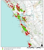
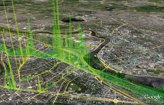
The project lays out around 10,000 geotagged tweets and 30,000 point-to-point trips in cities like New York City to plot the flow of people in terms of favored paths. In his map of NYC, seen above, there is a huge ink blot lining Broadway; as we’ve long suspected, it looks like the busy avenue is the backbone of the city.

Using a base map from OpenStreetMap, he drew out transit paths using Tweets. Movements are indicated on the geolocation of a Tweet, with an individual’s start point marked with one geotagged Tweet and ending with the next geotagged Tweet. This is what creates a mass of traffic routes.

Similar viz of the east bay“If you just draw lines from the beginning to the ending of each trip, you get a big mess, so the challenge is to come up with more plausible routes in between,” Fischer told Mashable. “That is where the 10,000 individual geotags come in, the most plausible routes are ones that pass closely through places that other people have been known to go.”

Fischer used Dijkstra’s Algorithm to calculate what exactly to map out. For those of who haven’t thought about math since high school algebra, that’s an equation that maps out the shortest path between two points on a graph. For this project, the equation pointed to the relevant paths to map out a city’s most dense corridors.

This might be of use for our mobility project with our space.

More here.

That was fast! Supreme Court rules on GPS & privacy

From the NYTimes today. The Supreme Court on Monday unanimously ruled that the police violated the Constitution when they placed a Global Positioning System tracking device on a suspect’s car and monitored its movements for 28 days.

But the justices divided 5-to-4 on the rationale for the decision, with the majority saying that the problem was the placement of the device on private property. That ruling avoided many difficult questions, including how to treat information gathered from devices installed by the manufacturer and how to treat information held by third parties like cellphone companies.

Walter Dellinger, a lawyer for the defendant in the case and a former acting United States solicitor general, said the decision “is a signal event in Fourth Amendment history.” “Law enforcement is now on notice,” he said, “that almost any use of G.P.S. electronic surveillance of a citizen’s movement will be legally questionable unless a warrant is obtained in advance.”

Previous wrap-up post on the case.

troubling report of OSM vandalism

From Sarah. This is a troubling story from ReadWriteWeb reporting that someone at a range of Google IP addresses in India has been editing the collaboratively made map of the world in some very unhelpful ways, like moving and deleting information and reversing the direction of one-way streets on the map.

Update: Google sent the following statement to ReadWriteWeb on Tuesday morning. "The two people who made these changes were contractors acting on their own behalf while on the Google network. They are no longer working on Google projects."

A Google spokesperson told BoingBoing on Friday that the company was "mortified" by the discovery - but now it appears the same Google contractor may be behind mayhem rippling throughout one of the world's biggest maps. Google says it's investigating these latest allegations.

TanDEM-X and TerraSAR-X cover the globe

TanDEM's view of Iceland: The country was beyond the sight of the shuttle topography mission in 2000We talked about TanDEM before, after launch. The German satellite radar twins - TanDEM-X and TerraSAR-X - are a year through their quest to make the most precise, seamless map of varying height on Earth.

They've now acquired data across the entire globe at least once. However, some tricky sampling areas, such as tall mountains and thick forests, will require several passes and so we don't expect to see a fully finished product before 2014.

As compared with the Shuttle product at best spatial resolution of 30m by 30m, and a vertical resolution that varies from 16m to 10m, the intention of the TanDEM mission is to go down to a spatial resolution of 12m by 12m and a vertical resolution of 2m. Airbone lidars can achieve much better precision, but these maps are necessarily regional in extent - they will cover only relatively small areas. The purpose of TanDEM is to build a world DEM that is single-source and has "no joins".

Report from the BBC here.

The TanDEM Digital Elevation Model of Mount Etna, Sicily, Italy

mapping gas leaks in Boston

The Google Earth image above shows shafts of bright green indicating natural gas leaking around BU's Charles River Campus. If there are multiple leaks, the display “looks like a stock market index during a busy day,” says Nathan Phillips. Photo courtesy of Nathan Phillips and Picarro, Inc.This is a very interesting report about work at BU Geography and Environment department to map gas leaks across the city. Nathan Phillips, Bob Ackley and Eric Crosson use a Nissan-mounted methane sensor to survey for leaks, and map results on a google earth scene. The accompanying video shows the setup, and discusses some nasty real time implications for trees as gas replaces oxygen in the soil. Also, this is just nuts to think of how much wasted gas is going up in a typical city. Yikes!