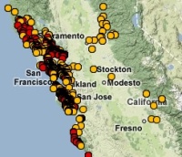
 Hi y'all. The new OakMapper 2.0 is up and running, and we'd like your help in mapping areas of oak mortality around the state. Version 2.0 improves upon the website's prior version with increased functionality and additional tools within an easily navigated interface. Launched by the UC Berkeley Kelly lab in October, OakMapper 2.0 makes it easier for users to explore data, download maps, look at images of oak mortality, and submit suspected locations of oak mortality that may be associated with SOD. The new interface utilizes the familiar background layers and navigation tools from Google Maps. Users are able to draw points and polygons directly on the map as well as attach photos to specific points. The Kelly lab encourages the public to use this site to map suspected cases of SOD and to track their submission by signing up for an account with OakMapper. Registered users of the site can update their information and make comments on other users' points. Official confirmations of P. ramorum are clearly separated from community-submitted points and either set of points can be filtered out.The new OakMapper is found at oakmapper.org. Please consider signing up to be an OakMapper user! The OakMapper was recently featured in the recent journal of the Bay Area Automated Mapping Association
.