UC ANR group wins extension award

Several UC Cooperative Extension and UC scientists have been awarded the Western Extension Directors Association Award of Excellence for work to address the outbreak of sudden oak death in California. Led by Yana Valachovic, the group developed extension programming that achieved outstanding accomplishments, results and impacts in addressing this important issue. We were recognized for: 

  • understanding the issue and situation; 
  • working with stakeholders;
  • having a research base and an extension focus;
  • evidencing multidisciplinary and collaborative components;
  • incorporating innovative approaches;
  • achieving impacts; and
  • developing scholarly products. 

The people involved in the group award are: Yana Valachovic, Steve Swain, Matteo Garbelotto, Janice Alexander, Lisa Bell, Bendan Twieg, Dave Rizzo, Steve Tjosvold, David Lewis, Doug McCreary, Katie Palmieri, Kerri Frangioso, Jim MacDonald, Ellie Rilla, Maggi Kelly, Rick Standiford, Chris Lee, Doug Schmidt, Brice McPherson, and Richard Dodd. 

New GIF Director: Nancy Thomas

The GIF welcomes our new Executive Director Nancy Thomas, who joins us Monday November 10th. Nancy comes to us from the Spatial Analysis Center at Stanford. She has over 18 years of experience in managing successful remote sensing and GIS projects in both consulting and academic arenas. She was a early employee of Pacific  Meridian, one of the first remote sensing companies on the west coast. She has extensive experience in the development and analysis of geospatial data to map, monitor, and model land use and land cover for a variety of domestic and international natural resource management applications. She's given numerous presentations and workshops on geospatial technologies, and has facilitated numerous successful collaborations and training of geospatial research methods.

Please stop by the GIF and welcome her to the Berkeley community!

Important proposed legislation limiting UAVs: consider reading this and commenting

AB1327 is a bill that could potentially impact the work that we do in regards to remote sensing and aerial imagery collection, etc… in the near future. See the link below for more detail. The office of the California CIO, Scott Gregory, is in the process of providing the Legislature a summary analysis of the bill. In our analysis we want to highlight civilian use (non-public safety governmental) cases for UAV technology as a rebuttal to some of the limiting language in the bill.

The bill would generally prohibit public agencies from using unmanned aircraft systems, or contracting for the use of unmanned aircraft systems, as defined, with certain exceptions applicable to law enforcement agencies and in certain other cases. The bill would require reasonable public notice to be provided by public agencies intending to deploy unmanned aircraft systems, as specified. The bill would require images, footage, or data obtained through the use of an unmanned aircraft system under these provisions to be permanently destroyed within 6 months, except as specified.

http://leginfo.legislature.ca.gov/faces/billNavClient.xhtml?bill_id=201320140AB1327
 
If this bill will affect your organization’s future data collection needs, please provide them a brief summary to be incorporated into the analysis.

Here is what I have sent to Scott Gregory:

Maggi Kelly

Department of Environmental Sciences, Policy and Management

UC Berkeley

The use of civilian accessed UAV technology is commonly used for research purposes to aquire imagery at critical times over inaccessible field sites such as wetlands and forests, or over agricultural fields throught the growing season. This remote data acquisition using UAVs has several advantages: 1) it limits damage of the site, 2) it allows for mutliple returns in a cost-effective way, and 3) it allows for important very high resolution imagery to be collected. Here is a paper where we perfected techniques to find weeds in an agricultural field using UAV imagery. http://www.plosone.org/article/info%3Adoi%2F10.1371%2Fjournal.pone.0077151

Basically, they are looking for the organization name, use case and description of that use case. Please circulate to the user community within your respective organizations to solicit feedback. Please email or call if you have any questions. He would like to have these complied by 10am Friday (3/14/14).

Email: Scott Gregory Scott.Gregory@state.ca.gov

Thanks for your help.

Cal Forestry turns 100 this year!

Forestry education at UC Berkeley began in 1914 with the “Division of Forestry” in the Department of Agriculture. The Department of Forestry was established in 1939 and the School of Forestry in 1946. Forest Summer Camp, the hallmark of the undergraduate program, began at Quincy, California, in 1915 and moved to Meadow Valley in 1917.

Today, alumni of Cal’s forestry program hold critical positions for the management of 95% of the industrial forestlands in California. The research of our alumni and faculty has grown knowledge in the areas of fire, remote sensing and GIS, ecology, climate change, forest economics, the social sciences, and numerous others.

Over the past 100 years, the Cal Forestry program has had an impact on every dimension of the field, and has produced the profession’s most influential thinkers and doers.

For more information, please see: http://nature.berkeley.edu/forestry100/about-us

Graduate 
Certificate
 in 
GIS approved for UC Berkeley

 Great news! 

The UC Berkeley Graduate 
Certificate 
in
 Geographic 
Information 
Science 
and
 Technology
 (GIST)
 has been approved. This certificate will provide
 an 
academic
 structure 
for 
an 
interdisciplinary 
exchange 
of
 ideas 
around
 geospatial
 information 
and 
analysis. 

 Certificate
 students 
will
 not 
only
 participate 
in
 a 
cutting‐edge 
program 
and
 receive
 explicit
 recognition
 of 
specialization 
in
 GIST
 by 
virtue 
of
 the
 Graduate
 Certificate 
but
 will 
be
 well
 positioned
 to
compete
 for 
the
 most
 desirable 
jobs 
in 
geospatial
 technology,
 both 
in
 academia
 and 
in 
industry.

Requirements include at
 least 
three 
courses, 
or 
a
 total
 of
 90 
hours
 of
 instruction, 
and
 earn 
a
 minimum 
grade
 of
, and participate in a GIST Roundtable (such as the geolunch series from the GIF). More details to be posted in the spring at GIS@Berkeley.edu.

Study Finds Spatial Skill Is Early Sign of Creativity

From the NYTimes: http://www.nytimes.com/2013/07/16/us/study-finds-early-signs-of-creativity-in-adults.html

A gift for spatial reasoning — the kind that may inspire an imaginative child to dismantle a clock or the family refrigerator — may be a greater predictor of future creativity or innovation than math or verbal skills, particularly in math, science and related fields, according to a study published Monday in the journal Psychological Science.

Go GIS!

Hey OakMappers! Updated OakMapper available for iPhones and iPads

The new OakMapper logo

We are excited to announce the new version (2.3) of the OakMapper iPhone/iPad App, available to download now for free at the iTunes App Store [link].

In this version of the OakMapper App, the original browse and search functionalities have been retooled to improve the user interface design and user interaction. A new user can sign up for a new OakMapper account directly using the App. Users who has logged into their account can manage their profile, change their password, and submit a SOD point. The submission process has been re-engineered to achieve a better and more intuitive submission workflow. Users can also take a picture of a suspected SOD infected tree and upload it right from their iOS devices.

To explore all the new features of the OakMapper iPhone/iPad App, please install OakMapper from the iTunes App Store [link] now. Please feel free to share this App with your friends. If you like the OakMapper app, please rate the app and leave your comments in the App store. If you should have any questions, please email us at oakmapper@gmail.com.

Enjoy!

OakMapper
Shufei Lei, Web/Mobile App Developer
Maggi Kelly, Principal Investigator
www.oakmapper.org

BAAMA Summer Happy Hour - July 17 2013 - Free!

BAAMA Summer Happy Hour!!!

Free for everyone!

Who: Bay Area GEOSPATIAL Community

All are welcome! If you are OR are not a BAAMA member, love our group, or have never been to an event but want to check out our organization, this is a great gathering for you.  Come and hang out with your fellow spatial sleuths and map lovers.

What:

  • Hot dogs, and potato and cole slaw (supplied by Bay Area-vendor Top Dog)
  • A large keg of beer and other non-alc beverages (we won't run out this time)
  • Cookies
  • The outdoors (maybe a little late-afternoon sun)
  • Hang out with people you only read about on LinkedIn and Twitter…..
  • Offer up your great ideas in the BAAMA Board

When: Wednesday July 17, 2012

6:00 pm – 8:00 pm
Hot dogs served from 6:00 pm - 7:30 pm

Where: UC Berkeley, Courtyard behind Mulford Hall

37.87315 -122.26471

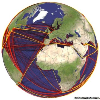
map of global routes of ship-borne invasive species

From the BBC. Scientists have developed the first global model that analyses the routes taken by marine invasive species. The researchers examined the movements of cargo ships around the world to identify the hot spots where these aquatic aliens might thrive. The research is published in the Journal Ecology Letters.

Scientists mapped the global routes taken by cargo ships over a two-year period

Marine species are taken in with ballast water on freighters and wreak havoc in new locations, driving natives to extinction.

There has been a well-documented boom in global shipping over the past 20 years and this has led to growing numbers of species moving via ballast tanks, or by clinging to hulls.

Some ports such as San Francisco and Chesapeake Bay have reported several exotic new species arriving every year. Economic estimates indicate that marine invaders can have huge impacts that last for decades.

Now, scientists from the UK and Germany have developed a model that might help curb these unwanted visitors. They obtained detailed logs from nearly three million voyages that took place in 2007 and 2008. The model combines information such as shipping routes, ship sizes, temperatures and biogeography to come up with local forecasts of invasion probabilities.

ANR Statewide Program on GIS

Mission Statement: IGIS aims to support high-priority programs to advance research and extension projects that enhance agricultural productivity, natural resource conservation and healthy communities into the future by providing Informatics and Geospatial Information Systems tools and applications.

ANR Recently announced the development of a new Statewide Program called the Informatics and GIS (IGIS) program. The new program aims to over the next five years become the nexus for ANR’s rich and diverse geospatial and ecological data, research information, and resources for academics and the public who rely on geospatial and informatics data, analysis and display.  Through data capture, information sharing, and collaboration, we aim to increase our ability to make meaningful predictions of the agricultural, ecosystem, and community response to future change, to increase our understanding of California’s diverse natural, agricultural and human resources, and to support research and outreach projects that enhance agricultural productivity, natural resource conservation and healthy communities into the future.

The IGIS team needs your input to design this resource to be an efficient and helpful delivery of information and GIS support. If you are affiliated with ANR, please take a few minutes to complete the Survey of Informatics and GIS Needs, Knowledge and Data Availability.  This is a short and comprehensive survey that will assess GIS, data and information needs, evaluate your level of informatics and GIS expertise and use of geospatial tools and data.  Your response will be of great assistance toward building a successful State-wide program.

Update from LDCM

Some updates from this video from NASA:

  • Imagery should be available late May 2013
  • Landsat 7 has enough fuel to last until 2016
  • LCDM has a 5 year mission, but they are hopeful for a 10 year mission
  • Data continuity is the key to this whole deal: "continuity drives landsat"
  • High resolution data does not have the temporal resolution as Landsat - via Kass G.

Very excited.

LDCM FAQ here.


Landsat 8 is up and orbiting!

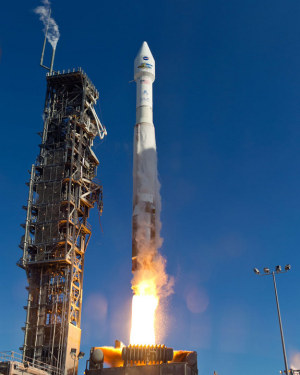
Atlas 5 Rocket With Landsat PayloadFun day today watching the LDCM (Landsat Data Continuity Mission) make its successful launch of the newest and coolest sensor in the Landsat family. The flawless launch from Vandenburg AFB was witnessed with lots of cheering and earth-themed cupcakes in Mulford Hall!

While I am not actively using Landsat imagery, I used Landsat 4 and 5 imagery for my dissertation, back in the day, and use it still to introduce geographic concepts in class. And I am super excited to see the new imagery. The sensor has similar spectral bands to the ETM+ sensor on Landsat 7, but also I think includes a new coastal aerosol band (443 nm) and cirrus detection band (1375 nm). The legacy of the Landsat program is tremendous; the program has given us reliable, comprehensive, and detailed views of a dynamic earth for decades. It is a government sponsored science program with lasting impact.

Some nice write-ups about Landsat:

NASA Earth Observatory Landsat Looks and Sees
NASA Landsat: http://www.nasa.gov/mission_pages/landsat/main/index.html
USGS Landsat Missions: http://landsat.usgs.gov/
Landsat Top 10: http://www.nasa.gov/mission_pages/landsat/news/landsat-40th-top10.html

Anyway, it was nice to have everyone on board to witness the launch! Thanks GIF folks and everyone else in the lab. Now we just have to watch out for DA14 on Friday!

New Landsat Satellite set to launch Feb 11th

NASA's Landsat Data Continuity Mission (LDCM) is scheduled to launch Feb. 11 from Vandenberg Air Force Base in California. A joint NASA and U.S. Geological Survey (USGS) mission, LDCM will add to the longest continuous data record of Earth's surface as viewed from space.

LDCM is the eighth satellite in the Landsat series, which began in 1972. The mission will extend more than 40 years of global land observations that are critical in many areas, such as energy and water management, forest monitoring, human and environmental health, urban planning, disaster recovery and agriculture. NASA and the USGS jointly manage the Landsat Program. Check out more info.

On the eve on GIS Day, the word of 2012: GIF!

Today the Huffington Post announced that the Word of the Year in 2012, according to the Oxford American Dictionaries, is GIF. Alas, they aren't talking about our GIF, fantastic resource for all things geospatial on the Berkeley campus, provider of innovative web mapping projects, source of useful training, meeting place for like-minded spatial aware professionals, and host of tomorrow's GIS Day, but about the humble Graphics Interchange Format, "relic of the 80s" and slave to internet kitties everywhere, which turned 25 this year. Still, this semantic confusion is likely to drive up our search results! Go GIF!

New ANR Statewide Program on GIS announced

We are pleased to announce the development of a new statewide program called the ANR Informatics and Geographic Information Systems Statewide Program (IGIS). IGIS will organize, digitize and make Web-accessible some of California’s longest continuous data pertaining to agriculture and natural ecosystems, including weather and productivity related to management inputs — concrete data for modeling responses to change across the state.

IGIS will be supported and directed by a leadership team including Maggi Kelly (director), Lisa Fischer, Karl Krist and Joni Rippee, with key staff Shane Feirer, Kris Lynn-Patterson and Todd Perez. The responsibilities of the leadership team are to maintain IGIS direction, explore collaborations and maintain connection between ANR and UC campuses.  The team will work with an advisory board that will assist the leadership team on all components of IGIS from data standardization and acquisition to data access and specific project selection and feedback from potential users.

Our vision is that over the next five years IGIS will provide a home for ANR’s rich and diverse collection of data, information and resources for academics and members of the public who rely on geospatial and informatics data, analysis and display.

In service of the ANR continuum, University of California researchers, academics from other institutions and the public, IGIS will provide the ability to connect with rich and diverse ANR resources, datasets and information through an online web accessible portal. IGIS will assist in applied research and extension activities that rely on geospatial data, analysis and display. IGIS will offer networking and collaboration and, when possible, provide training and research support on important agricultural and natural resource issues.

Specifically, IGIS will become the umbrella for ANR-wide GIS and informatics activities in order to

Provide coordination for research and extension activities that require GIS and/or geospatial analysis
Provide acquisition, storage and dissemination of large data sets from ANR Research and Extension Centers for researchers, managers and the public via Web-access (REC RAC, REC Web, Cal-EON)
Create a virtual GIS and Informatics service center to provide for project level work that has Division-wide application (GIS Service Center)
For more information, please see our developing website http://ucanr.edu/sites/IGIS.

Barbara Allen-Diaz
Vice President, Agriculture and Natural Resources

Land Change Science Position Open!

We are very excited to have open a new Cooperative Extension specialist position in Land Change Science. The successful Land Change CE specialist will have a PhD, and will develop a vibrant applied research program, primarily based in California. There are no formal teaching duties with this position, instead, the incumbant will have outreach and extension duties.

We are searching for someone who can help us understand, predict and plan for the complexities of land use change in California. This might be someone from geography, landscape ecology, sociology, or economics, for example, and might focus on planning, modeling or observations of land change, biophysical feedbacks from land change, or spatial analysis. But they must be an adept and capable communicator who can speak to diverse audiences, from landowners, to politicians, to farmers, to scientists, to planners, to citizens.

The Specialist would provide science-based solutions and bridge conflicting interests with knowledge, targeted research, and local education regarding the relationships between expanding population and climate change, and the remaining matrix of wild landscapes, urban areas, working landscapes and agriculture.

The Specialist would provide resources for county-based Cooperative Extension personnel, including learning from UCCE personnel about the needs of decision makers at the local level, and acting as a information and training resource for the use of new tools (GIS, remote sensing, smart phone applications, etc.) for land use analysis.

Please consider applying if this fits you! I will be happy to answer questions.

Pre-development Delta report from SFEI

The San Francisco Estuary Institute-Aquatic Science Center is pleased to announce the publication of its latest report, Sacramento-San Joaquin Delta Historical Ecology Investigation: Exploring Pattern and Process. The report is the culmination of several years of research synthesizing thousands of pieces of historical evidence with contemporary scientific understanding. The report provides new information about how the Delta functioned to provide habitat for native species and includes dozens of rarely seen historical accounts, maps, and photographs. For more information, please see today's press release.

The report and Geographic Information System (GIS) data are available for download here. Printed copies of the report will be available in several weeks, at a cost of $75 each (plus tax/shipping).

Media Contacts:
Robin Grossinger, Senior Scientist, San Francisco Estuary Institute-Aquatic Science Center, (510) 746-7380 (office), 510 326 3732 (cell), or robin@sfei.org

Carl Wilcox, Policy Advisor to the Director for the Bay-Delta, California Department of Fish and Game, (707) 738-4134, or cwilcox@dfg.ca.gov

Philadelphia food desert eradication project

Here is a recent article from the Washington Post examining Philadelphia's Get Healthy Philly initiative. $900,000 from the project is going to be spent on turning 632 corner stores in the city into green grocers. The effort helps these corner stores buy and supply fresh fruits and vegetables and buy the infrastructure needed to store them, such as refrigerators.

This effort goes in hand with a new study in the city that will examine what happens when more nutritious foods are introduced into traditionally underserved neighborhoods. Measuring what people bought before, what they’re eating now, and how health outcomes change. The article also explores other research on food deserts, access to healthy foods, and health outcomes with lessons learned.

For the full article click here.