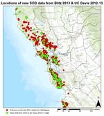
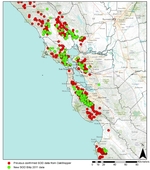
UC ANR group wins extension award
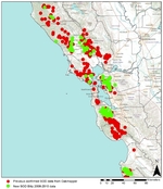
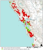
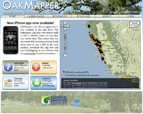
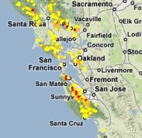
Several UC Cooperative Extension and UC scientists have been awarded the Western Extension Directors Association Award of Excellence for work to address the outbreak of sudden oak death in California. Led by Yana Valachovic, the group developed extension programming that achieved outstanding accomplishments, results and impacts in addressing this important issue. We were recognized for: 

  • understanding the issue and situation; 
  • working with stakeholders;
  • having a research base and an extension focus;
  • evidencing multidisciplinary and collaborative components;
  • incorporating innovative approaches;
  • achieving impacts; and
  • developing scholarly products. 

The people involved in the group award are: Yana Valachovic, Steve Swain, Matteo Garbelotto, Janice Alexander, Lisa Bell, Bendan Twieg, Dave Rizzo, Steve Tjosvold, David Lewis, Doug McCreary, Katie Palmieri, Kerri Frangioso, Jim MacDonald, Ellie Rilla, Maggi Kelly, Rick Standiford, Chris Lee, Doug Schmidt, Brice McPherson, and Richard Dodd. 

OakMapper Mobile Updated (v2.4) - available now at the App Store

OakMapper Mobile has been updated (version 2.4) to take take advantage of the latest iOS interface design and requirements. It is available for download at the Apple App Store. Existing OakMapper Mobile users are encouraged to update to the latest version.

In the last 6 months, the site receives over 1,100 visitors, resulting in over 1,450 sessions this period, which is consistent with the same period last year. Visitors come mostly from the US; and within the US states, California dominates. There are 14 new registered users from the community. Participation from the community includes 4 new SOD submissions (721 total), 1 new comment about SOD, 6 new questions/feedback, and 2 new votes on whether they have seen the reported SOD cases.

Our paper published in the Annals of the Association of American Geographers has been cited 17 times according to Google Scholar.


Connors, J. P., S. Lei & M. Kelly (2012): Citizen Science in the Age of Neogeography: Utilizing Volunteered Geographic Information for Environmental Monitoring, Annals of the Association of American Geographers, 102(6): 1267-1289

New 2012-2013 SOD Confirmations Added to OakMapper!

New 2013 SOD Blitz and 2012-13 UC Davis DataNew confirmed cases of Sudden Oak Death (SOD) (P. ramorum) have been added to OakMapper, a project that tracks the spread of Sudden Oak Death from data collected by citizens and organizations. All official SOD cases are collected and confirmed by the California Department of Food and Agriculture or the University of California. Community SOD cases are submitted by citizens via the OakMapper website and iPhone application. 442 new points collected between 2012-2013 have been added to OakMapper bringing the total number of confirmed SOD locations to 3246. The new data consists of laboratory confirmed cases collected by the annual SOD Blitz campaign of 2013 from the Forest Pathology and Mycology Lab run by Dr. Matteo Garbelotto and also laboratory confirmed cases collected by the UC Davis Rizzo Lab run by Dr. David Rizzo.

Click on the image left to view a close-up of the new confirmed SOD data (in green) from SOD Blitz and UC Davis. 

Explore the new data online here.

OakMapper.org


Hey OakMappers! Updated OakMapper available for iPhones and iPads

The new OakMapper logo

We are excited to announce the new version (2.3) of the OakMapper iPhone/iPad App, available to download now for free at the iTunes App Store [link].

In this version of the OakMapper App, the original browse and search functionalities have been retooled to improve the user interface design and user interaction. A new user can sign up for a new OakMapper account directly using the App. Users who has logged into their account can manage their profile, change their password, and submit a SOD point. The submission process has been re-engineered to achieve a better and more intuitive submission workflow. Users can also take a picture of a suspected SOD infected tree and upload it right from their iOS devices.

To explore all the new features of the OakMapper iPhone/iPad App, please install OakMapper from the iTunes App Store [link] now. Please feel free to share this App with your friends. If you like the OakMapper app, please rate the app and leave your comments in the App store. If you should have any questions, please email us at oakmapper@gmail.com.

Enjoy!

OakMapper
Shufei Lei, Web/Mobile App Developer
Maggi Kelly, Principal Investigator
www.oakmapper.org

New 2012 SOD Confirmations Added to OakMapper!

New SOD Blitz 2012 Data

New confirmed cases of Sudden Oak Death (SOD) (P. ramorum) have been added to OakMapper, a project that tracks the spread of Sudden Oak Death from data collected by citizens and organizations. All official SOD cases are collected and confirmed by the California Department of Food and Agriculture or the University of California. Community SOD cases are submitted by citizens via the OakMapper website and iPhone application. 613 new points collected in 2012 have been added to OakMapper bringing the total number of confirmed SOD locations to 2804. The new data consists of laboratory confirmed cases collected by the annual SOD Blitz campaign of 2012 from the Forest Pathology and Mycology Lab run by Dr. Matteo Garbelotto. 

Click on the image in the upper left to view a close-up of the new confirmed SOD data (in green) from the SOD Blitz 2012. 

Explore the new data online here.

OakMapper.org

What is "success" with post-disaster crowdsourcing?

At a recent workshop I gave on webGIS, after giving an overview of some of the recent uses of crowdsourced and VGI in disasters (fire in San Diego, earthquake in Christchurch, Ushahidi everywhere...), I was asked about success of these projects. Who used the data? How? (and who funded these websites, but that is another story.) And I had only the vaguest of answers. Here is a thoughful critique on this subject by Paul Currion on MobileActive.org. He examines the use of the Ushahidi project in Haiti. Paul is an aid worker who has been working on the use of ICTs in large-scale emergencies for the last 10 years.  He asks whether crowdsourcing adds significant value to responding to humanitarian emergencies, arguing that merely increasing the quantity of information in the wake of a large-scale emergency may be counterproductive. Why? because aid workers need clear answers, not a fire-hose of information. Information from the crowd needs to be curated, organized, targeted for response. He makes the point that since crowdsourced data is going have to be sorted through, and can be biased, and can be temporary, aid agencies are going to have to carry out exactly the same needs assessments that they would done without the crowdsourced information.

Where and when do crowdsourced data add value to a situation or project? How can we effectively deal with the bias in the data that comes naturally? We deal with this all the time in my smaller web-related projects: oakmapper and snamp for example. What is the future role of the web for adaptive forest management for example? How do these new collaborative and extensive tools help us make important decisions about natural resources management in often contentious contexts? More to think about.

New 2011 SOD Confirmations Added to OakMapper!

New SOD Blitz 2011 Data

New confirmed cases of Sudden Oak Death (SOD) (P. ramorum) have been added to OakMapper, a project that tracks the spread of Sudden Oak Death from data collected by citizens and organizations. All official SOD cases are collected and confirmed by the California Department of Food and Agriculture or the University of California. Community SOD cases are submitted by citizens via the OakMapper website and iPhone application. 621 new points collected in 2011 have been added to OakMapper bringing the total number of confirmed SOD locations to 2191. The new data consists of laboratory confirmed cases collected by the annual SOD Blitz campaign of 2011 from the Forest Pathology and Mycology Lab run by Dr. Matteo Garbelotto. 

Click on the image below to view a close-up of the new confirmed SOD data (in green) from the SOD Blitz 2011. 

Explore the new data online here.

OakMapper.org

SOD: still spreading in the bay area

A nice article in SF Chron on Matteo's citizen science approach to mapping new SOD spread.

The article states: The deadly pathogen known as sudden oak death is spreading throughout the Bay Area, infecting more trees in more places than have ever been seen before, according to scientists tracking the disease. The Forest Pathology and Mycology Laboratory at UC Berkeley used 10,000 tree and plant samples collected by 500 citizens between April and June this year to document a dramatic increase in the infection rate from Napa to the Carmel Valley and virtually everywhere in between.

New SOD Confirmations Added to OakMapper!

New confirmed cases of Sudden Oak Death (SOD) (P. ramorum) have been added to OakMapper, a project that tracks the spread of Sudden Oak Death from data collected by citizens and organizations. All official SOD cases are collected and confirmed by the California Department of Food and Agriculture or the University of California. Community SOD cases are submitted by citizens via the OakMapper website and iPhone application. 415 new points collected between 2008 and 2011 have been added to OakMapper bringing the total number of confirmed SOD locations to 1570. The new data consists of laboratory confirmed cases collected by the annual SOD Blitz campaigns of 2008-2010 from the Forest Pathology and Mycology Lab run by Dr. Matteo Garbelotto and also data collected by the California Department of Food and Agriculture between 2008 and 2011.

Click on the images below to view close-ups of the new confirmed SOD data (in green) from the SOD Blitz and California Department of Food and Agriculture (CDFA).

New SOD Blitz 08-10 Data

New CDFA 08-11 Data


Explore the new data online here

OakMapper.org

Apps for Oak Trees: Can social media help save a forest?

From the East Bay Express: a nice article by Caitlin Esch about mobile apps, citizen science and environmental science. The article features the OakMapper, and ken-ichi ueda's iNaturalist, and UC Davis' Roadkill Observation System. The article includes a nice history of the OakMapper, including our early days wrangling faxes and hand-drawn maps, and the early inspiration for the site: the USGS Earthquake Mapper.

OakMapper in the news!

OakMapper is featured in a new ANR news report from Pam Kan Rice. Check it out here. From the article:

Smartphone users can report sudden oak death

California’s majestic oak trees have been felled by the hundreds of thousands by a disease first reported in 1995 and dubbed “sudden oak death.”  To get a broader perspective on the disease, UC Berkeley scientists have developed a smartphone app for hikers and other nature lovers to report trees they find that have succumbed to sudden oak death.

While out in a park or forest, iPhone users can use the new OakMapper mobile application to report sightings of trees killed by Phytophthora ramorum, the plant pathogen that causes sudden oak death. Onsite, they can note the symptoms they see, such as seeping, bark discoloration, crown discoloration, dead leaves, shoot die-back, fungus, beetle frass and beetle bore holes. The OakMapper app, created by scientists in the UC Berkeley Geospatial Innovation Facility, uses the phone's built-in GPS to identify the participant’s location when the data is submitted.

Some favorite ecology-related mashups

From Ken-ichi Ueda and friends: iNaturalist.org.

  • Where you can record what you see in nature, meet other nature lovers, and learn about the natural world. Colorful, well-designed and useful, this site is a must for all you explorers of the natural world, or those of you who just ponder the wildlife in your backyard.

From GreenInfo Network and CalLands:

  • The new California Protected Areas Database (CPAD 1.3) has just been released in geodatabase and shape file formats, and is available through google maps overlay here.

From UC Davis' Road Ecology Center and the Information Center for the Environment: California Roadkill Observation System.

  • You can report roadkills you observe anywhere in the state, helping all of us to understand the causes of roadkill and how we can reduce the conflict between animals and vehicles. Roadkill is a major cause of mortality for many animals in California, but designing appropriate management responses takes political support, money, and knowledge of where and how to act. Roadkill data are an important part of that equation and we invite you, our expert colleagues, to join us in collecting these data on a public site.

From my lab: the OakMapper.

  • OakMapper is designed to let users explore the locations of confirmed P. ramorum sites, and contribute to our database by reporting trees that might have the disease. And it is now mobile! Speaking of mobile:

From Imperial College London: EpiCollect.

  • A mobile phone application will help professional and "citizen" scientists collect and analyse data from "in the field", anywhere in the world. The EpiCollect software collates data from certain mobiles - on topics such as disease spread or the occurrence of rare species - in a web-based database. Uses Android. The BBC article.


OakMapper has gone mobile!

Not be mistaken with OatsMapper.com (mapping Hall and Oats reunion concerts), the OakMapper has gone mobile!

If you have an iPhone with OS 3.0, you can now download and install the mobile version of OakMapper on iTune's App Store for free. The mobile version of OakMapper allows you to do the same thing as the web version: view submitted Sudden Oak Death cases and report a SOD occurrence. However, the OakMapper makes those two actions much easier by taking advantage of the GPS unit onboard the iPhone. The GPS coordinates provided by the iPhone will allow you to quickly report an SOD case and will allow you to find out all the submitted SODs within a 20 miles radius around you. We hope that the ease of reporting SOD cases using the OakMapper iPhone application will encourage more submissions from the general public who own an iPhone. 

GPS vs. GPS

There has been some buzz on the blogs about the possibility of smart phones replacing more standard recreational grade GPS devices. This article in the NY Times suggests that the smartphone is beginning to displace the GPS receiver as a convenient way for drivers to get directions to unknown destinations.

Next might be the use of smart phones for non-driving uses of the recreational GPS devices, like geocaching, or science education.  We will be releasing our OakMapper device for the iPhone in September, and will likely be better able to comment on the comparison.

Indigenous mapping network at UC Berkeley

Our friends from DataBasin are on campus on Monday. Kai Henifin is a Cultural Ecologist/GIS Analyst with the non-profit organization Conservation Biology Institute, the developers of DataBasin. Kai will be speaking about "Incorporating Indigenous Knowledge to Improve Conservation through Data Sharing" as part of the Berkeley Indigenous Mapping Network. For more info on the event.

We have some interesting cross-overs with CBI and DataBasin: we added our SOD data to DataBasin recently (see image at left); and CBI have a nice modeling project looking at fisher in the southern Sierra that Reg and Rick are using in their SNAMP work.

iPhone apps for environmental science

Having just set up a HOBO weather station over the weekend (ain't she pretty?), and being dismayed at having to use my windows computer to control it, I wondered about other ways to monitor the environment.  Amazingly, but perhaps not surprisingly, there are many new iPhone apps out there for us to investigate. 

For example: the recent NPR study about soil moisture monitoring via the iPhone is interesting. The sensors themselves are very expensive, but are monitored via an iPhone app.

Also: this new Wind Meter app, which I am going to test at lunch today. Seems fun, but a far cry from a real anemometer.

And of course: we will soon be releasing our OakMapper iPhone app.

Sudden Oak Death Science Symposium Highlights

I thought I'd post some highlights from the SOD Science Symposium, currently running in Scotts Valley, CA.

Dave Rizzo presented new disease information since the first isolations (9 years ago this week!) in 2000 to today. Some highlights include:

  • Across California, there has been filling in of existing areas of the disease, but new areas of confirmation of note:
    • furthest north in CA is 45 miles north of Redway, CA; confirmed from stream baiting, and is associated with a nursery. No terrestrial confirmations. In Mendocino, another river baiting example north of Fort Bragg; no terrestrial confirmations.
  • There are some exciting management projects ongoing, from preventative treatment to large-scale management.

Alan Kanaskie talked about the Oregon situation. Highlights include:

  • Tanoak is critical for SOD in Oregon;
  • Monitoring in OR depends on aerial surveys, field surveys and stream baiting. With these methods, they are confident that ramorum only exists in the known quarantine area. However, they are getting rare PCR confirmations out of steam baiting in new watersheds, but they have not been able to replicate with culture, nor have they found any newly infected trees in those watersheds.
  • They are confident their management approach is working to slow the spread, and compares a map of Humboldt and Curry counties; in Humboldt, things look worse than in Curry.

Sandra Denman from Forest Research in UK gave an update on Pr in Europe: still mainly a nursery problem, but some interesting facts include:

  • Coutries reporting Pr in Europe in 2000 were few, and only 4 countries had outdoor outbreaks; in 2008: 19 countries report Pr in nurseries, and "burgeoning" reports of outdoor outbreaks across western and southern europe.
  • In the UK, Pr has been found in 600 nurseries in UK. In outdoor outbreaks, rhodies are the main problem, and outside outbreaks on trees are associated with these ornamentals.
  • First use of "kerfuffel" in a science presentation that I have heard.
  • P. kernoviae is also important in UK; and last year Pk was found in the Republic of Ireland for the first time.

Clive Brasier, from UK Forestry Commission, talked about P species and increased invasions due to international trade, and weak international biosecurity. Before 2000, about 20% of P sp were threats to forests; since 2000 (with 50+ new P species named), about 60% are threats to trees and forests. He guesses there might be 100-500 unnamed P. species out there that could be invasive in forests. They are now hypothesizing that Pr came from Japan and/or Taiwan.

For more on Sudden Oak Death, check out the OakMapper site, and other oakmapper posts on this blog.