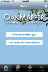
OakMapper Mobile Updated (v2.4) - available now at the App Store

OakMapper Mobile has been updated (version 2.4) to take take advantage of the latest iOS interface design and requirements. It is available for download at the Apple App Store. Existing OakMapper Mobile users are encouraged to update to the latest version.

In the last 6 months, the site receives over 1,100 visitors, resulting in over 1,450 sessions this period, which is consistent with the same period last year. Visitors come mostly from the US; and within the US states, California dominates. There are 14 new registered users from the community. Participation from the community includes 4 new SOD submissions (721 total), 1 new comment about SOD, 6 new questions/feedback, and 2 new votes on whether they have seen the reported SOD cases.

Our paper published in the Annals of the Association of American Geographers has been cited 17 times according to Google Scholar.

Connors, J. P., S. Lei & M. Kelly (2012): Citizen Science in the Age of Neogeography: Utilizing Volunteered Geographic Information for Environmental Monitoring, Annals of the Association of American Geographers, 102(6): 1267-1289

Citizen science: key questions explored in a new report

In a recent article published in the Guardian, Michelle Kilfoyle and Hayley Birch discuss the widespread use of citizen science initiatives. They recently produced a report (pdf) for the Science for Environment Policy news service, in which the authors review a number of citizen science case studies, and explore the potential benefits of citizen science for both science and society, especially given the advent of new mobile technologies that enable remote participation. They also ask interesting questions about who really benefits the most from these developments: the amateurs or the professionals?

Key questions addressed and highlighted in this report include:
  1. How could new and developing technologies help citizen science projects feed into environmental policy processes?
  2. Is environmental data produced by citizen scientists as accurate as environmental data produced by professional scientists?
  3. How can citizen science benefit environmental monitoring and policymaking?

Workshop wrap up: Google Earth Higher Education Summit 2013

For three days in late July 2013 Kevin Koy, Executive Director of the GIF and Maggi spent time at Google with 50+ other academics and staff to learn about Google Earth's mapping and outreach tools that leverage cloud computing. The meeting was called Google Earth for Higher Education Summit, and it was jam packed with great information and hands-on workshops. Former Kellylabber Karin Tuxen-Bettman was at the helm, with other very helpful staff (including David Thau - who gave the keynote at last year's ASPRS conference). Google Earth Outreach has been targeting non-profits and K-12 education, and are now increasingly working with higher education, hence the summit. We learned about a number of valuable tools for use in classrooms and workshops, a short summary is here.  

Google Mapping Tools - the familiar and the new

  • Google Earth Pro. You all know about this tool, increasing ability to plan, measure and visualize a site, and to make movies and maps and export data.
  • Google Maps Engine Lite. This is a free, lite mapping platform to import, style and embed data. Designed to work with small (100 row) spreadsheets.
  • Google Maps Engine Platform. The scaleable and secure mapping platform for geographic data hosting, data sharing and map making. streamlines the import of GIS data: you can import shapefiles and imagery. http://mapsengine.google.com.
  • Google Earth Engine. Data (40 years of global satellite imagery - Landsat, MODIS, etc.) + methods to analyze (Google's and yours, using python and javascript) + the Cloud make for a fast analytical platform to study a changing earth. http://earthengine.google.org/#intro
  • TimeLapse. A new tool showcasing 29 years of Landsat imagery, allows you to script a tour through a part of the earth to highlight change. Features Landsat 4, 5 7 at 30m, with clouds removed, colors normalized with MODIS. http://earthengine.google.org/
  • Field Mobile Data Collection. GME goes mobile, using Open Data Kit (ODK) - a way to capture structured data and locate it and analyze after home.
  • Google Maps APIs. The way to have more hands-on in map styling and publishing. developers.google.com/maps
  • Street View. They have a car in 32 countries, on 7 continents, and are moving into national parks and protected areas. SV is not just for roads anymore. They use trikes, boats, snowmobiles, trolleys; they go underwater and caves, backpacks.

Here are a couple of my first-cuts:

Tim De Chant explains why you should be excited about vector-based maps in iOS 6

Former kellylabber Tim De Chant has a nice piece on the upcoming apple mapping software for mobile devices:

Apple announced today that it’s revamping the Maps application on iOS devices—iPhone, iPad, iPod touch—introducing a lot of showy new features like turn-by-turn directions and 3D flyovers. While those make for sexy commercials, they won’t be as impactful as the switch from raster- to vector-based map data. If you’re not sure why you should be excited about the change—and you should be—read on.

Check out his blog post here.


Jonathan Crowe (formerly of The Map Room, now of "My Correct Views on Everything") has a comprehensive post on the subject here.

Apple mobile mapping software? coming soon!

We mac users are all a-twitter about the news of an impending Apple mapping software. Here is a sample from NPR:

There's been speculation for months that Apple will try to elbow Google's popular Maps app aside on the iPhone and unveil its own map app, and some of the best evidence yet comes from Tuesday's Wall Street Journal.  The paper looked into the reasons for the impending switch and the broader implications it would have for the smartphone market.  The article continues...

The new software is rumored to be leaner, meaner, and packing a rad 3D visualization capability. It will be unveiled as soon as next week at the annual Apple developer conference in San Francisco.

Livehoods: Dynamic maps of place via social networking

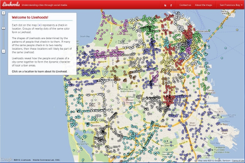
Livehoods is an interesting research project from the School of Computer Science at Carnegie Mellon University which maps social networking activity and patterns using tweets and check-ins to examine the hidden structure of cities and neighborhoods. For example below on the map each point represents a check-in location. Groups of nearby points of the same color represent a Livehood. Within a Livehood statistics are calculated aggregating check-ins overtime and depicts how a place is used. For more information on Livehoods click here.

Livehoods Screenshot

A wrap-up of the news surrounding Supreme Court's foray into GPS + privacy

United States vs. Jones raises questions about the limits of police searches, personal privacy and the use of new technology in law enforcement. At issue is whether police need warrants to attach GPS tracking devices to a cars to monitor suspects' movements for indefinite periods of time.

Stay tuned for more analysis. From NPR, some indication that the Supreme Court was not happy with un-warranted GPS tracking. The justices were told police could slap GPS devices on their cars and track their movements, without asking a judge for advance approval.

Also an interesting take from Wired: A number of Supreme Court justices invoked the specter of Big Brother while hearing arguments Tuesday over whether the police may secretly attach GPS devices on Americans’ cars without getting a probable-cause warrant.

While many justices said the concept was unsettling, the high court gave no clear indication on how it will rule in what is arguably one of the biggest Fourth Amendment cases in the computer age. The Obama administration maintains that Americans have no privacy rights when it comes to their movements in public.

Another informative opinion piece from the Washington Post.

Google acquires facial recognition technology company

Missed this earlier, but found it in prep for my privacy and GIS lecture. The article is excerpted here:

Google has acquired a seven-year-old company that develops facial-recognition technology for images and video, though the Web-search giant didn’t say what it plans to do with it.

Regarding face recognition, the spokesman said, “We’ve said that we won’t add face recognition to our apps or product features unless we have strong privacy protections in place, and that’s still the case.”

Google has said it built facial recognition technology for smartphones into a product known as Google Goggles, but withheld it. “As far as I know, it’s the only technology that Google built and after looking at it, we decided to stop,” said Google Chairman Eric Schmidt last month at a conference. “People could use this stuff in a very, very bad way as well as in a good way.”

Google Goggles is pretty sweet, by the way.

Very high res urban mapping: research reported at the Berkeley BEARS 2011 EECS Annual Research Symposium

February 17th Berkeley Electrical Engineering and Computer Sciences (EECS) Annual Research Symposium some interesting new developments and research in the world of information technology were showcased. The first section of the symposium hosted four talks about current and future research at UC Berkeley in IT focusing on large scale data mining, aggregation and analysis; artificial intelligence and language processing; augmenting reality with virtual and mobile systems of information display and collection; and sensor/communication nanotechnology.

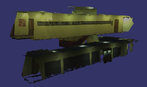
Most notable in application to GIS, although far off, it was mentioned that work is underway to try to miniaturize the lasers in LiDAR sensors to the scale of inserting them into mobile phones to enable collective 3D ground mapping of urban areas from mobile users and for placement in building materials to monitor building occupants/conditions. More current was the talk from Avideh Zakhor about work in the VIP lab on combining data from mobile ground based sensors, similar to those used to create Google street view, with aerial photos to create 3D urban models at varying resolutions (Read more) (Video). Also in development is putting the same technology that is used to create Google street view of exterior streets in the interiors of buildings. This enables the creation of 3D interior building models and photorealistic walk through environments of interior spaces. This may have many implications in emergency  preparedness/management, design, and marketing (Read more) (Example image below).

Source: Image from Avideh Zakhor homepage: http://www-video.eecs.berkeley.edu/~avz/

Check out the BEARS 2011 website here for more information and for video recordings of the talks to be up soon.

For more information on the individual presenters: Ion Stoica, Dan Klein, Avideh Zakhor, Kristofer Pister, and Jan Rabaey.

OakMapper in the news!

OakMapper is featured in a new ANR news report from Pam Kan Rice. Check it out here. From the article:

Smartphone users can report sudden oak death

California’s majestic oak trees have been felled by the hundreds of thousands by a disease first reported in 1995 and dubbed “sudden oak death.”  To get a broader perspective on the disease, UC Berkeley scientists have developed a smartphone app for hikers and other nature lovers to report trees they find that have succumbed to sudden oak death.

While out in a park or forest, iPhone users can use the new OakMapper mobile application to report sightings of trees killed by Phytophthora ramorum, the plant pathogen that causes sudden oak death. Onsite, they can note the symptoms they see, such as seeping, bark discoloration, crown discoloration, dead leaves, shoot die-back, fungus, beetle frass and beetle bore holes. The OakMapper app, created by scientists in the UC Berkeley Geospatial Innovation Facility, uses the phone's built-in GPS to identify the participant’s location when the data is submitted.

Google Navigation announced for Android phones

Smart phones featuring Android 2.0 will now support a new Navigation feature developed by Google

From their blog:

This new feature comes with everything you'd expect to find in a GPS navigation system, like 3D views, turn-by-turn voice guidance and automatic rerouting. But unlike most navigation systems, Google Maps Navigation was built from the ground up to take advantage of your phone's Internet connection.

This application will including turn-by-turn directions, overlayed on Google's satellite and street views, which looks very cool. 

Check out the video:

Now I just need my new Droid...

Some favorite ecology-related mashups

From Ken-ichi Ueda and friends: iNaturalist.org.

  • Where you can record what you see in nature, meet other nature lovers, and learn about the natural world. Colorful, well-designed and useful, this site is a must for all you explorers of the natural world, or those of you who just ponder the wildlife in your backyard.

From GreenInfo Network and CalLands:

  • The new California Protected Areas Database (CPAD 1.3) has just been released in geodatabase and shape file formats, and is available through google maps overlay here.

From UC Davis' Road Ecology Center and the Information Center for the Environment: California Roadkill Observation System.

  • You can report roadkills you observe anywhere in the state, helping all of us to understand the causes of roadkill and how we can reduce the conflict between animals and vehicles. Roadkill is a major cause of mortality for many animals in California, but designing appropriate management responses takes political support, money, and knowledge of where and how to act. Roadkill data are an important part of that equation and we invite you, our expert colleagues, to join us in collecting these data on a public site.

From my lab: the OakMapper.

  • OakMapper is designed to let users explore the locations of confirmed P. ramorum sites, and contribute to our database by reporting trees that might have the disease. And it is now mobile! Speaking of mobile:

From Imperial College London: EpiCollect.

  • A mobile phone application will help professional and "citizen" scientists collect and analyse data from "in the field", anywhere in the world. The EpiCollect software collates data from certain mobiles - on topics such as disease spread or the occurrence of rare species - in a web-based database. Uses Android. The BBC article.


OakMapper has gone mobile!

Not be mistaken with OatsMapper.com (mapping Hall and Oats reunion concerts), the OakMapper has gone mobile!

If you have an iPhone with OS 3.0, you can now download and install the mobile version of OakMapper on iTune's App Store for free. The mobile version of OakMapper allows you to do the same thing as the web version: view submitted Sudden Oak Death cases and report a SOD occurrence. However, the OakMapper makes those two actions much easier by taking advantage of the GPS unit onboard the iPhone. The GPS coordinates provided by the iPhone will allow you to quickly report an SOD case and will allow you to find out all the submitted SODs within a 20 miles radius around you. We hope that the ease of reporting SOD cases using the OakMapper iPhone application will encourage more submissions from the general public who own an iPhone. 

GPS vs. GPS

There has been some buzz on the blogs about the possibility of smart phones replacing more standard recreational grade GPS devices. This article in the NY Times suggests that the smartphone is beginning to displace the GPS receiver as a convenient way for drivers to get directions to unknown destinations.

Next might be the use of smart phones for non-driving uses of the recreational GPS devices, like geocaching, or science education.  We will be releasing our OakMapper device for the iPhone in September, and will likely be better able to comment on the comparison.

iPhone apps for environmental science

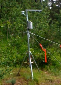
Having just set up a HOBO weather station over the weekend (ain't she pretty?), and being dismayed at having to use my windows computer to control it, I wondered about other ways to monitor the environment.  Amazingly, but perhaps not surprisingly, there are many new iPhone apps out there for us to investigate. 

For example: the recent NPR study about soil moisture monitoring via the iPhone is interesting. The sensors themselves are very expensive, but are monitored via an iPhone app.

Also: this new Wind Meter app, which I am going to test at lunch today. Seems fun, but a far cry from a real anemometer.

And of course: we will soon be releasing our OakMapper iPhone app.

Maps + Compass

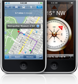
In iPhone OS 3.0, a digital compass will be provisioned, which could potentially add more helpful features to the existing Google Map application. Already, the soon-to-released OakMapper Mobile is taking advantage the open API for Google Map in iPhone SDK 3.0beta to create an application that allow iPhone users to view and report SODs on their iPhones. I believe that the future iteration of the OakMapper Mobile application can take advantage the built-in compass to re-trace the reported SODs.