New GPS/GLONASS Base Station installed on UC Berkeley campus. Happy geo-locationing!

California Surveying and Drafting recently installed a GPS/GLONASS base station antenna on McCone Hall and to reciprocate they’re allowing Berkeley researchers to use the real-time correction signal for free. This could be useful for anyone doing research in California with access to a mapping-grade or survey-grade GNSS unit such as a Trimble Geoexplorer. You’ll need to tether your Trimble to a strong 3G/4G wifi signal (for example from your cell phone) so this approach will only work in regions with cellular reception. 

Initial tests show under 5cm of error with a Trimble GeoXH 6000 unit on campus. Thanks Nico!

Mobile Field Data Collection, Made Easy

Recommendation from Greeninfo Network's MapLines newsletter:

"Attention land trusts, weed mappers, trail maintainers and others - Are you ready for the Spring field work season?  GreenInfo recommends using this customizable, free app for collecting data in the field - Fulcrum App, which offers a free single user plan for storing up to 100 mb of data."

According to their website, with Fulcrum, you build apps to your specifications, allowing you to control exactly what data is captured from the field and how. Maintain high standards of quality to minimize rework, QA/QC, and error correction by getting it done right the first time.

DNRGarmin + QGIS for a free and useful way to map properties

This website shows how any average computer user and/or landowner or forester can utilize the Quantum GIS open source freeware to do professional analyses of their land or their clients' land for free. Thanks Bob Wagoner!

http://www.centralillinoisforestry.com/index.php/illinois-forestry-blog/73-quantum-gis-for-landowners-and-practitioners

That was fast! Supreme Court rules on GPS & privacy

From the NYTimes today. The Supreme Court on Monday unanimously ruled that the police violated the Constitution when they placed a Global Positioning System tracking device on a suspect’s car and monitored its movements for 28 days.

But the justices divided 5-to-4 on the rationale for the decision, with the majority saying that the problem was the placement of the device on private property. That ruling avoided many difficult questions, including how to treat information gathered from devices installed by the manufacturer and how to treat information held by third parties like cellphone companies.

Walter Dellinger, a lawyer for the defendant in the case and a former acting United States solicitor general, said the decision “is a signal event in Fourth Amendment history.” “Law enforcement is now on notice,” he said, “that almost any use of G.P.S. electronic surveillance of a citizen’s movement will be legally questionable unless a warrant is obtained in advance.”

Previous wrap-up post on the case.

The evolving privacy debate: Jeffrey Rosen on Fresh Air

Last month in GIS class we had a lively discussion about GIS and privacy. We discussed the idea that while privacy is defined differently in social and legal domains, usually with legal frameworks being a more reactive than prescriptive, at least in the US. But legal and social norms are increasingly shaped by technology: facebook and the like might be pushing the bounds on what is socially acceptable to reveal about yourself, lowering our tolerance for invasions of privacy; smaller GPS make it easier for the police to surveil suspects. Anyway, in a Fresh Air great show, George Washington University law professor Jeffrey Rosen, the co-editor of the new book Constitution 3.0: Freedom and Technological Change, details how technological changes that were unimaginable at the time of the Founding Fathers are challenging our notions of things like personal vs. private space, freedom of speech and our own individual autonomy. It is a fascinating interview:

http://www.npr.org/2011/11/30/142714568/interpreting-the-constitution-in-the-digital-era

A wrap-up of the news surrounding Supreme Court's foray into GPS + privacy

United States vs. Jones raises questions about the limits of police searches, personal privacy and the use of new technology in law enforcement. At issue is whether police need warrants to attach GPS tracking devices to a cars to monitor suspects' movements for indefinite periods of time.

Stay tuned for more analysis. From NPR, some indication that the Supreme Court was not happy with un-warranted GPS tracking. The justices were told police could slap GPS devices on their cars and track their movements, without asking a judge for advance approval.

Also an interesting take from Wired: A number of Supreme Court justices invoked the specter of Big Brother while hearing arguments Tuesday over whether the police may secretly attach GPS devices on Americans’ cars without getting a probable-cause warrant.

While many justices said the concept was unsettling, the high court gave no clear indication on how it will rule in what is arguably one of the biggest Fourth Amendment cases in the computer age. The Obama administration maintains that Americans have no privacy rights when it comes to their movements in public.

Another informative opinion piece from the Washington Post.

Animal tracking with "Smart Collars"

There is an interesting arcticle in today's New York Times about the use of a new breed of animal tracking collars that use on board computers to track valuable information about an animal, beyond location alone.  The new "smart collars" can be used to track when an animal is sleeping, when it is feeding, and lots of other metrics.  The additional data being gathered gives biologists more information to work with while trying to understand the animals habits and needs, in order to provide informed wildlife management decisons.

Yikes! GPS surveillance reported on NPR

One more for the privacy files. From NPR.org. When Yasir Afifi took his car in for an oil change, his mechanic found an unusual wire hanging from below. It was part of a black rectangular device attached to his car by a magnet. After posting photos of it on an online forum, where posters identified it as a GPS tracking device, Afifi, a Santa Clara, Calif., college student and computer salesman, got a visit from FBI agents demanding their equipment back.

The FBI confirms the device belongs to the agency and that agents visited Afifi to get it back. But Special Agent Joseph Schadler won't say why it was there. Full article


Researching why animals move across the land

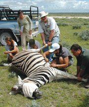
Collaring a zebraA very nice article about Wayne Getz's research in Africa: spatial ecology, epidemiology, conservation and citizen science. From Breakthroughs Magazine

In this article he talks about his evolution as a scientist from mathematician to geo-nerd. The article states: At the core of Getz’s work is how and why animals move across the land. People have sought answers to these questions for time immemorial - at first to improve success in the hunt and harvest, and much later to understand animals in and of themselves. His approach combines a mathematician’s genius for analysis with hands-on wildlife research. This unique perspective is revealing that animal travel patterns can provide a great number of insights into animal behavior, ecology, and epidemiology.

And now the GIS part: In recent years, the advent of global positioning system technologies, coupled with expanded telecommunications networks, have added up to a revolution in animal tracking. The modern version of the radio collar can map an animal’s position to within a couple of meters every few minutes, upload the stored data automatically to a satellite or cell phone network, and allow biologists to track the beast from afar for many weeks. 

Also read about his work in education and social justice in South Africa. Cool stuff. Check it.

First in new fleet of GPS satellites launches May 27, finally

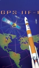
The GPS IIF artworkMay is a big month for GPS. Ten years ago selective availability of GPS signals was disabled, making accurate GPS technology available to the public rather than just the U.S. military. Boy was field work hard back then - all that map reading!

And this week the Air Force will launch the first of the next generation of GPS satellites - the IIF SV-1. The new satellites each transmit three civilian GPS signals — we’ve typically been making do with just one for years — including a military-strength transmission that should enable autopilots to land with zero visibility. This means always-on GPS that’s accurate to within 3 feet, even indoors and in concrete urban canyons. From Wired.

According to the launch material, each IIF satellite will deliver:

  • Two times greater predicted signal accuracy than heritage satellites;
  • New L5 signals for more robust civil, commercial aviation;
  • Military signal "M-code" and variable power for better resistance to jamming in hostile environments;
  • A 12-year design life providing long-term service and reduced operating costs; and
  • An on-orbit, reprogrammable processor, receiving software uploads for improved system operation.

More information here.

Orthorectifying for the Masses

In a bit of Tom Sawyer-inspired app making, the New York Public Library has created an online application for rectifying their collection of digital maps of New York City. "Finding control points is so much fun! It is truly an honor to allow you, our special internet browser, to assist us in collecting them." The NYPL Map Rectifier allows you to export the rectified maps as KMLs. They've also added a separate section for maps of Haiti to assist in earthquake relief. 

Mapping the arctic tern's amazing pole-to-pole flight

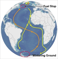
After setting out (yellow line) the birds pause in the North Atlantic (red circle) to feed. Going home (orange line), they follow the winds.We still might not know the air-speed velocity of an unladen swallow, but now we know the daily flight distance (up to 500km!) of the tiny arctic tern. Reported in the BBC.

Starting in August and September, the small (3.5oz) bird will head from Greenland and fly to the Weddell Sea, on the shores of Antarctica. It will spend about four or five months in the deep south before heading back to the far north, arriving home in May or June.

A team from Greenland, Denmark, the US, the UK and Iceland attached small (0.05oz) geolocating archival light loggers to the birds' legs to find out exactly where they went on this polar round trip. The devices do not rely on satellite navigation, but record light intensity.  This gives an estimate of the local day length, and the times of sunrise and sunset; and from this information it is possible to work out a geographical position of the birds. They banded 50 birds in July 2007 in Greenland, and one year later collected the devices from 10 birds (more birds with loggers were seen in the colony, but these could not be recaptured). More on these cool devices here.  More info on these amazing birds here.

Google Navigation announced for Android phones

Smart phones featuring Android 2.0 will now support a new Navigation feature developed by Google

From their blog:

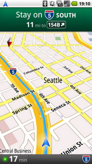
This new feature comes with everything you'd expect to find in a GPS navigation system, like 3D views, turn-by-turn voice guidance and automatic rerouting. But unlike most navigation systems, Google Maps Navigation was built from the ground up to take advantage of your phone's Internet connection.

This application will including turn-by-turn directions, overlayed on Google's satellite and street views, which looks very cool. 

Check out the video:

Now I just need my new Droid...

Fall 2009 GIF workshop schedule posted

The fall 2009 workshop schedule at berkeley's geospatial innovation facility (GIF) is posted! There are several new workshops scheduled, including:

  • Intro to Geographic Information Systems (GIS): Social Science Focus;
  • Intro to Open Source GIS: Working with Quantum GIS (QGIS);
  • Intro to Agent-Based Modeling: Using GIS data with NetLogo; and
  • Intro to LIDAR applications in Remote Sensing.

Check out the website!

GPS vs. GPS

There has been some buzz on the blogs about the possibility of smart phones replacing more standard recreational grade GPS devices. This article in the NY Times suggests that the smartphone is beginning to displace the GPS receiver as a convenient way for drivers to get directions to unknown destinations.

Next might be the use of smart phones for non-driving uses of the recreational GPS devices, like geocaching, or science education.  We will be releasing our OakMapper device for the iPhone in September, and will likely be better able to comment on the comparison.

Maps + Compass

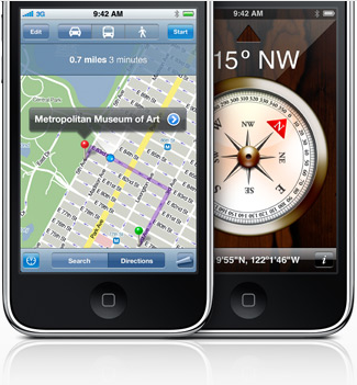
In iPhone OS 3.0, a digital compass will be provisioned, which could potentially add more helpful features to the existing Google Map application. Already, the soon-to-released OakMapper Mobile is taking advantage the open API for Google Map in iPhone SDK 3.0beta to create an application that allow iPhone users to view and report SODs on their iPhones. I believe that the future iteration of the OakMapper Mobile application can take advantage the built-in compass to re-trace the reported SODs.


Ghost Maps

There are over 35 million geotagged, time-stamped photos on flickr now. That's enough to start doing some pretty interesting analyses, including this one from Crandall, et al., at Cornell (presented at the WWW 2009 conference, "Mapping the World's Photos" [PDF]).  Not only is it possible to map hot spots of world tourism, but by incorporating the time stamps to map the routes people are taking, you can make out individual streets. As suggested by the Information Aesthetics blog, you could even design popular walking tours.

Once GPS-enabled cameras represent a larger share of the market, flickr may provide data for all sorts of important analyses: tracking SOD, the migration of an endangered song bird, or estimating the "desolation" of a place: the world heat map that the Cornell group presents looks shockingly like the lights at night. The machine... it's ALIVE!!!