1966 Lunar Orbiter 1 Images of Earth Recovered

comparison of the original Earthrise image as seen by the public in 1966 and the restored image released in 2008Interesting article from Wired on the recovery of forgotten images from the 1966 Lunar Orbiter 1 mission. The images were taken from a probe orbiting the moon and contain images of the surface of the moon and distant Earth including the first high resolution photographs ever taken from behind the lunar horizon of an Earthrise. The images were recovered from analog data tapes at NASA Ames and have not been seen publicly since the original data from the mission was received in the late 1960s and never at such high resolution. The historical images of Earth are now being used to fill in gaps about Earth's climate in the 1960s. For the full story click here.

Landsat 8 is up and orbiting!

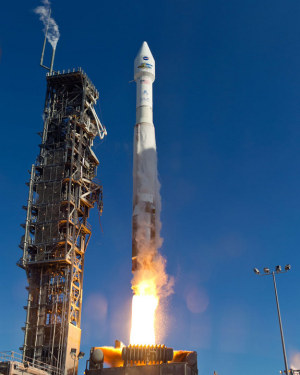
Atlas 5 Rocket With Landsat PayloadFun day today watching the LDCM (Landsat Data Continuity Mission) make its successful launch of the newest and coolest sensor in the Landsat family. The flawless launch from Vandenburg AFB was witnessed with lots of cheering and earth-themed cupcakes in Mulford Hall!

While I am not actively using Landsat imagery, I used Landsat 4 and 5 imagery for my dissertation, back in the day, and use it still to introduce geographic concepts in class. And I am super excited to see the new imagery. The sensor has similar spectral bands to the ETM+ sensor on Landsat 7, but also I think includes a new coastal aerosol band (443 nm) and cirrus detection band (1375 nm). The legacy of the Landsat program is tremendous; the program has given us reliable, comprehensive, and detailed views of a dynamic earth for decades. It is a government sponsored science program with lasting impact.

Some nice write-ups about Landsat:

NASA Earth Observatory Landsat Looks and Sees
NASA Landsat: http://www.nasa.gov/mission_pages/landsat/main/index.html
USGS Landsat Missions: http://landsat.usgs.gov/
Landsat Top 10: http://www.nasa.gov/mission_pages/landsat/news/landsat-40th-top10.html

Anyway, it was nice to have everyone on board to witness the launch! Thanks GIF folks and everyone else in the lab. Now we just have to watch out for DA14 on Friday!

India-Pakistan border as seen from space

From NASA re-posted via Bostom.com's The Big Picture photojournalist website comes this fascinating, geographically-pertinent image: "The India-Pakistan border appears as an orange line in this photograph taken by the Expedition 28 crew on the International Space Station on August 21, 2011. The fence between the two countries is floodlit for surveillance purposes. Srinagar (left), Islamabad (bottom center), Lahore (center near the border line) and Delhi (top center) can be seen as brighter spots. (NASA/Handout/Reuters)#"

Wall-E was right! Space junk mapped

Low earth orbitOrbital debris, or “space junk,” is any man-made object in orbit around the Earth that no longer serves a useful purpose. To minimize the risk of collision between spacecraft and space junk, the U.S. Space Surveillance Network tracks all debris larger than 10 centimeters. These images represent all man-made objects, both functioning and useful objects and debris, currently being tracked. Though the black dots that represent objects in space swarm around the Earth, obscuring the surface in the lower image, the space junk situation is not as dire as it may appear. The dots are not to scale, and space is a very big place. Collisions between large objects are fairly rare. The orbit of each piece is well known. If any debris comes into the path of an operating NASA satellite, flight controllers will maneuver the satellite out of harm’s way. From NASA's Earth Observatory.