Wrap up from #DroneCamp2017!

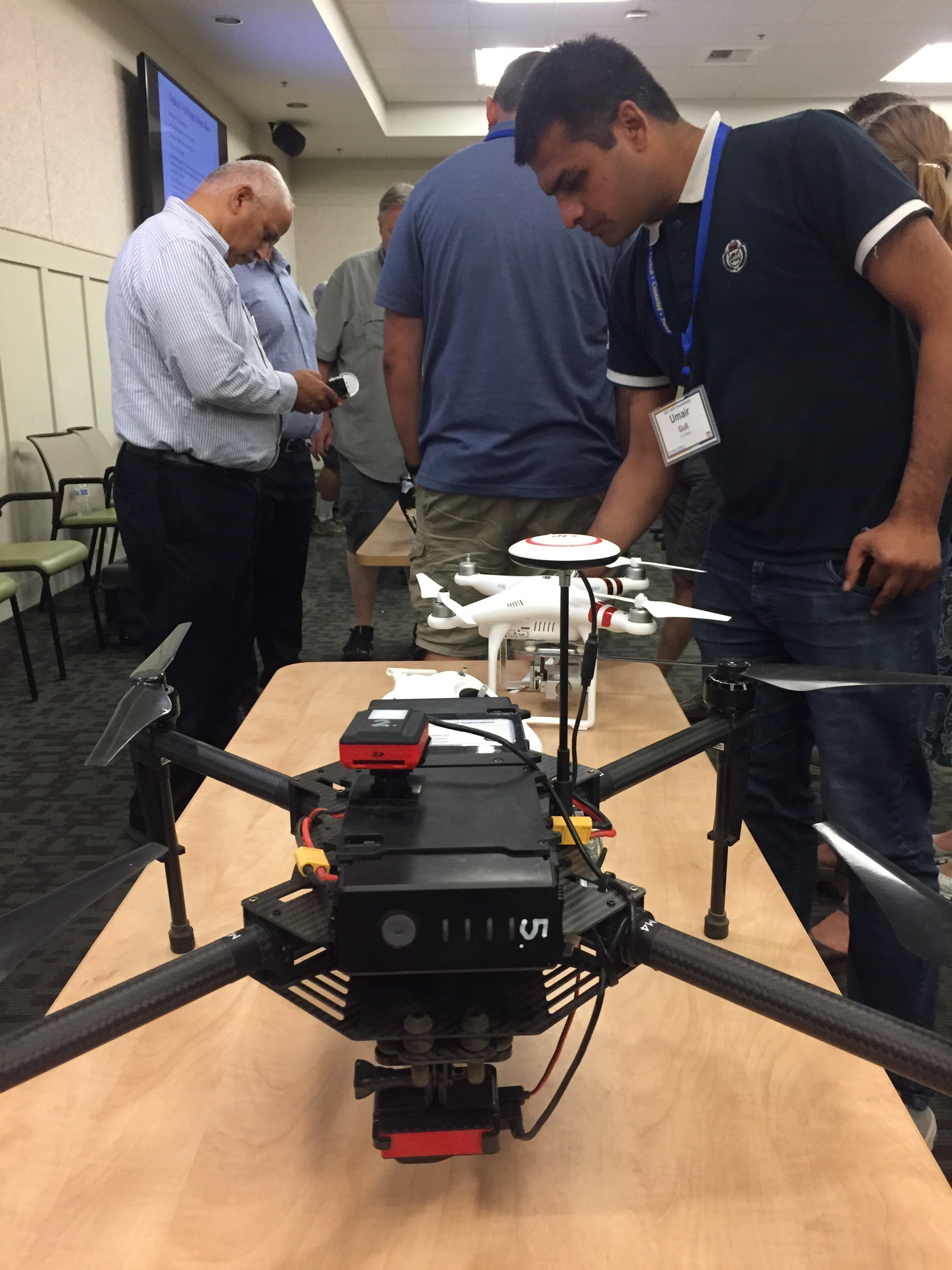
UC ANR's IGIS program hosted 36 drone enthusiasts for a three day DroneCamp in Davis California. DroneCamp was designed for participants with little to no experience in drone technology, but who are interested in using drones for a variety of real world mapping applications. The goals of DroneCamp were to:

  • Gain an broader understanding of the drone mapping workflow: including
    • Goal setting, mission planning, data collection, data analysis, and communication & visualization
  • Learn about the different types of UAV platforms and sensors, and match them to specific mission objectives;
  • Get hands-on experience with flight operations, data processing, and data analysis; and
  • Network with other drone-enthusiasts and build the California drone ecosystem. 

The IGIS crew, including Sean Hogan, Andy Lyons, Maggi Kelly, Robert Johnson, Kelly Easterday, and Shane Feirer were on hand to help run the show. We also had three corporate sponsors: GreenValley Intl, Esri, and Pix4D. Each of these companies had a rep on hand to give presentations and interact with the participants.

Day 1 of #DroneCamp2017 covered some of the basics - why drone are an increasingly important part of our mapping and field equipment portfolio; different platforms and sensors (and there are so many!); software options; and examples. Brandon Stark gave a great overview of the Univ of California UAV Center of Excellence and regulations, and Andy Lyons got us all ready to take the 107 license test. We hope everyone here gets their license! We closed with an interactive panel of experienced drone users (Kelly Easterday, Jacob Flanagan, Brandon Stark, and Sean Hogan) who shared experiences planning missions, flying and traveling with drones, and project results. A quick evaluation of the day showed the the vast majority of people had learned something specific that they could use at work, which is great. Plus we had a cool flight simulator station for people to practice flying (and crashing).

Day 2 was a field day - we spent most of the day at the Davis hobbycraft airfield where we practiced taking off, landing, mission planning, and emergency maneuvers. We had an excellent lunch provided by the Street Cravings food truck. What a day! It was hot hot hot, but there was lots of shade, and a nice breeze. Anyway, we had a great day, with everyone getting their hands on the commands. Our Esri rep Mark Romero gave us a demo on Esri's Drone2Map software, and some of the lidar functionality in ArcGIS Pro.

Day 3 focused on data analysis. We had three workshops ready for the group to chose from, from forestry, agriculture, and rangelands. Prior to the workshops we had great talks from Jacob Flanagan and GreenValley Intl, and Ali Pourreza from Kearney Research and Extension Center. Ali is developing a drone-imagery-based database of the individual trees and vines at Kearney - he calls it the "Virtual Orchard". Jacob talked about the overall mission of GVI and how the company is moving into more comprehensive field and drone-based lidar mapping and software. Angad Singh from Pix4D gave us a master class in mapping from drones, covering georeferencing, the Pix4D workflow, and some of the checks produced for you a the end of processing.

One of our key goals of the DroneCamp was to jump start our California Drone Ecosystem concept. I talk about this in my CalAg Editorial. We are still in the early days of this emerging field, and we can learn a lot from each other as we develop best practices for workflows, platforms and sensors, software, outreach, etc. Our research and decision-making teams have become larger, more distributed, and multi-disciplinary; with experts and citizens working together, and these kinds of collaboratives are increasingly important. We need to collaborate on data collection, storage, & sharing; innovation, analysis, and solutions. If any of you out there want to join us in our California drone ecosystem, drop me a line.

Thanks to ANR for hosting us, thanks to the wonderful participants, and thanks especially to our sponsors (GreenValley Intl, Esri, and Pix4D). Specifically, thanks for:

  • Mark Romero and Esri for showing us Drone2Map, and the ArcGIS Image repository and tools, and the trial licenses for ArcGIS;
  • Angad Singh from Pix4D for explaining Pix4D, for providing licenses to the group; and
  • Jacob Flanagan from GreenValley Intl for your insights into lidar collection and processing, and for all your help showcasing your amazing drones.

#KeepCalmAndDroneOn!

Day 2 Wrap Up from the NEON Data Institute 2017

First of all, Pearl Street Mall is just as lovely as I remember, but OMG it is so crowded, with so many new stores and chains. Still, good food, good views, hot weather, lovely walk.

Welcome to Day 2! http://neondataskills.org/data-institute-17/day2/
Our morning session focused on reproducibility and workflows with the great Naupaka Zimmerman. Remember the characteristics of reproducibility - organization, automation, documentation, and dissemination. We focused on organization, and spent an enjoyable hour sorting through an example messy directory of misc data files and code. The directory looked a bit like many of my directories. Lesson learned. We then moved to working with new data and git to reinforce yesterday's lessons. Git was super confusing to me 2 weeks ago, but now I think I love it. We also went back and forth between Jupyter and python stand alone scripts, and abstracted variables, and lo and behold I got my script to run. All the git stuff is from http://swcarpentry.github.io/git-novice/

The afternoon focused on Lidar (yay!) and prior to coding we talked about discrete and waveform data and collection, and the opentopography (http://www.opentopography.org/) project with Benjamin Gross. The opentopography talk was really interesting. They are not just a data distributor any more, they also provide a HPC framework (mostly TauDEM for now) on their servers at SDSC (http://www.sdsc.edu/). They are going to roll out a user-initiated HPC functionality soon, so stay tuned for their new "pluggable assets" program. This is well worth checking into. We also spent some time live coding with Python with Bridget Hass working with a CHM from the SERC site in California, and had a nerve-wracking code challenge to wrap up the day.

Fun additional take-home messages/resources:

Thanks to everyone today! Megan Jones (our fearless leader), Naupaka Zimmerman (Reproducibility), Tristan Goulden (Discrete Lidar), Keith Krause (Waveform Lidar), Benjamin Gross (OpenTopography), Bridget Hass (coding lidar products).

Day 1 Wrap Up
Day 2 Wrap Up 
Day 3 Wrap Up
Day 4 Wrap Up

Our home for the week

Our home for the week

GIF Bootcamp 2017 wrap up!

Our third GIF Spatial Data Science Bootcamp has wrapped!  We had an excellent 3 days with wonderful people from a range of locations and professions and learned about open tools for managing, analyzing and visualizing spatial data. This year's bootcamp was sponsored by IGIS and GreenValley Intl (a Lidar and drone company). GreenValley showcased their new lidar backpack, and we took an excellent shot of the bootcamp participants. What is Paparazzi in lidar-speak? Lidarazzi? 

Here is our spin: We live in a world where the importance and availability of spatial data are ever increasing. Today’s marketplace needs trained spatial data analysts who can:

  • compile disparate data from multiple sources;
  • use easily available and open technology for robust data analysis, sharing, and publication;
  • apply core spatial analysis methods;
  • and utilize visualization tools to communicate with project managers, the public, and other stakeholders.

At the Spatial Data Science Bootcamp we learn how to integrate modern Spatial Data Science techniques into your workflow through hands-on exercises that leverage today's latest open source and cloud/web-based technologies. 

ISECCI historical ecology working group wrap-up

Last week Kelly and I with others travelled to the Sierra Nevada Aquatic Research Lab (SNARL) in the eastern Sierra Nevada, just south of Mono Lake for a research retreat. SNARL is part of the UC's Natural Reserve System, which is comprised of nearly 40 properties across the state. These are preserves that foster research, education and collaboration. They have much in common with ANR's REC system. I've been to a few of them now, and am very pleased to make more visits. I love the east side of the Sierra, and that iconic Highway 395. 

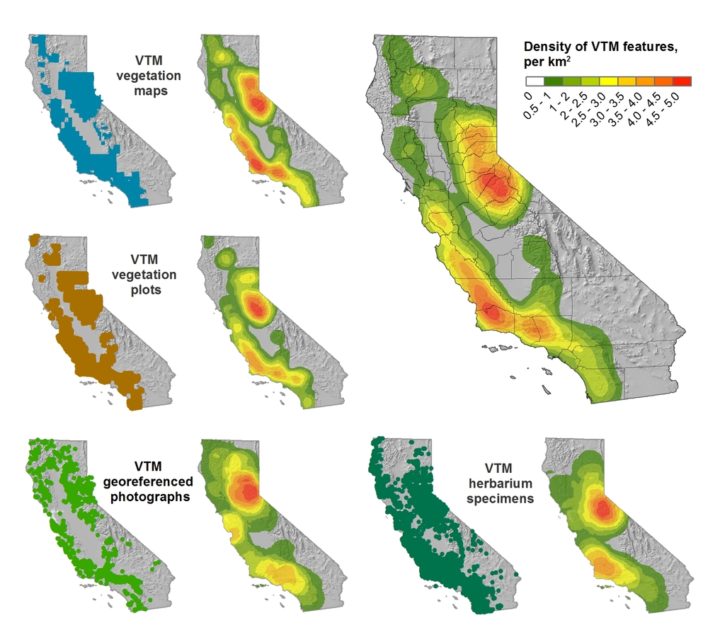
This trip was a retreat for the ISECCI historical ecology working group, led by the inspirational Peter Alagona from UCSB. We discussed our existing projects, including the VTM work (see figure below), and talked about potentials for more collaborative research and further integration between NRS and ANR. We have a list of wishes for digitization, and if anyone out there has ideas about pitching these to donors, please let me know. For example: 

  • Kelly and I want to digitize the Leiburg maps from the northern Sierra to add to the VTM stack;
  • We want to find a better way to index and view historical aerial photography state-wide. Something like this for historical maps: http://ngmdb.usgs.gov/maps/TopoView/help/

And we had a field trip looking at Mono Lake water issues. Great time spent!

Density of VTM features across the collections

Upcoming FREE GIF workshops

The GIF is highlighting 2 brand new workshops in the upcoming weeks. Because these are the first time we've done these sessions, I'm happy to announce that we are offering them free of charge to UC Berkeley students, researchers, faculty, and staff. The workshop seats will be filled on a first come first serve basis. Space is limited, so please register at: http://gif.berkeley.edu/support/workshops.html 

New Workshop: Intro to Geospatial Analysis using R 

This new workshop is designed for participants who are already familiar with GIS and spatial analysis concepts who are interested in using R. The presentation will introduce attendees to major spatial packages and concepts within the R environment. We will step through hands-on exercises exploring tools and methods for analyzing environmental data within R, and supply information for participants to continue their exploration of these methods in their own research projects.

Location: 124 Mulford Hall

Day: Friday, November 20th 

Time: 1:00-4:30 pm 

New Workshop: Web GIS and Mobile Data Collection using ArcGIS Online

This workshop is designed for participants with little to no GPS, GIS or web mapping experience. The workshop will include an interactive exercise that will have you building your own mobile data collection survey to be used with your Smartphone GPS. You will then see how this survey application seamlessly integrates with ArcGIS Online to create a web map that displays the survey results in real time.This course content is the result of a collaborative effort between UC ANR IGIS Statewide Program, and the UC Berkeley, Geospatial Innovation Facility (GIF)

Location: 124 Mulford Hall

Day: Friday, December 4th 

Time: 1:00-4:30 pm 

Register for these new training opportunities today! Space will fill up quickly, so make sure you register soon if you are interested. Also, feel free to pass this email onto your colleagues who may also be interested. If you have any questions, contact Nancy Thomas at nethomas@berkeley.edu.

2005-2015: A decade of intense innovation in mapping

The GIF began in November 2015 on a wave of excitement around geospatial technology. In the months leading up to our first GIS Day in 2005, Google Maps launched, then went mobile; Google Earth launched in the summer; and NASA Blue Marble arrived. Hurricane Katrina changed the way we map disasters in real time. The opening up of the Landsat archive at no-cost by the USGS revolutionized how we can monitor the Earth's surface by allowing dense time-series analysis. These and other developments made viewing our world with detail, ease, and beauty commonplace, but these were nothing short of revolutionary - spurring new developments in science, governance and business. The decade since then has been one of intense innovation, and we have seen a rush in geospatial technologies that have enriched our lives immeasurably. In November 2015 we can recognize a similar wave of excitement around geospatial technology as we experienced a decade ago, one that is more diverse and far reaching than in 2005. This GIS Day we would like to highlight the societal benefit derived from innovators across academia, non-profits, government, and industry. Our panel discussion on the 18th has representatives from several local innovators in the field, including: Stamen Designs, Geowing, PlanetLabs, 3D Robotics, NASA, iNaturalist.org, and Google, who will discuss their perspectives on the boom in Bay Area mapping. 

Please think about joining us at GIS Day!

http://gif.berkeley.edu/gisday.html

International Map Year

Did you know that it is International Map Year? 2015-2016.  

The International Map Year (IMY) is a worldwide celebration of maps and their unique role in our world. Supported by the United Nations, IMY provides opportunities to demonstrate, follow, and get involved in the art, science and technology of making and using maps and geographic information.

http://mapyear.org/about-international-map-year/

Think about ways in which maps can be integrated into your work!

Google Earth Engine @ the GIF!

Students, researchers, mappers, and big data enthusiasts took place in an exciting 2 day Google Earth Engine workshop this last week hosted by the GIF and the Google Earth Engine Team. We had an exiting overview of the latest and greatest research adventures from Google by Kelly lab alum Karin Tuxen-Bettman including advances in some of what Google Earth Outreach team is involved in...

As well as new/upcoming ventures

The Earth Engine team led some great tutorials getting people well versed in JavaScript and using the Earth Engine playground, and Earth Engine API. Having beginner and advanced workshop tracks during the two day event allowed for both broad and deep participation from researchers across the Berkeley campus. Take a look at the packed agenda and more

here!

We also had a stellar panel of UC Berkeley professor Jeff Chambers and graduate students Sophie Taddeo, Alexander Bryk, and Lisa Kelley who shared an intimate view of how they were using Earth Engine in their research. The panel shared stories of using Earth Engine to evaluate disturbance in tropical forests, map the movement of wetlands, and meandering rivers, as well as looking at agroforestry systems in Indonesia through a socio-ecological lens.

Thanks to Google and the Earth Engine Team for guiding, the GIF for hosting, and all of the participants for engaging in an action packed two days!

Questions about the Spatial Data Science Bootcamp? Read on!

In May, the GIF will be hosting a 3-day bootcamp on Spatial Data Science.

What is the significance of Spatial Data Science?

We live in a world where the importance and availability of spatial data is ever increasing, and the value of Spatial Data Science: big data tools, geospatial analytics, and visualization is on the rise. There are many new and distributed tools available to the geospatial professional, and the ability to efficiently evaluate and integrate the wide array of options is a critical skill for the 21st century marketplace.  Spatial Data Science offers a modern workflow that includes the integration of data from multiple sources and scales; with open-source and web-based technology for robust data analysis and publication; with core spatial concepts and application of spatial analysis methods; and allows for the collaborations of people – companies, scientists, policy-makers, and the public.

Why come to the GIF to learn about it?

The Geospatial Innovation Facility (GIF) at UC Berkeley is the premier research and educational facility in the Bay Area that focuses on a broad vision of Spatial Data Science. The GIF has a decade-long history of successful GIS and remote sensing research projects. The GIF has also trained many students, researchers, and community members in geospatial techniques and applications through our popular workshop series and private consultation. With more recent advances in web-based mapping capabilities, the GIF has been at the forefront of complex web-based spatial data informatics (web-based data sharing and visualization), such as the Cal-Adapt  tool, which provides a wealth of data and information about California’s changing climate. Participants will get the benefit of our decade-long focus on Spatial Data Science: collaborative project development, rigorous spatial analysis methods, successful interaction with clients, and delivery of results to project managers, the public, and other stakeholders.

What are the key elements of the Bootcamp?

This Bootcamp is designed to familiarize participants with some of the major advances in geospatial technology today: big data wrangling, open-source tools, and web-based mapping and visualization. You will learn how and when to implement a wide range of modern tools that are currently in use and under development by leading Bay Area mapping and geospatial companies, as well as explore a set of repeatable and testable workflows for spatial data using common standard programming practices. Finally, you will learn other technical options that you can call upon in your day-to-day workflows. This 3-day intensive training will jump start your geospatial analysis and give you the basic tools you need to start using open source and web-based tools for your own spatial data projects.  

Interested in integrating open source and web-based solutions into your GIS toolkit? Come join us at our May 2015 Bootcamp: Spatial Data Science for Professionals. Applications due: 3/16/2015. Sign up here!

New scholarly journal: Geospatial Applications in Natural Resources

The Arthur Temple College of Forestry and Agriculture, in conjunction with Stephen F. Austin State University, will soon launch a new scholarly journal titled “Journal of Geospatial Applications in Natural Resources”.  The focus of the journal will be to publish via a rapid double-blind peer-review process articles that apply geospatial technology to quantify, qualify, map, monitor, and manage natural resources.

There is no website yet, but I will keep you posted.

Google Geo for Higher Education Summit 2014


Just got back from an amazing workshop with the Google Earth Outreach Geo Team and 50+ geospatial educators, researchers, and lab managers! 

In between stealing off on the colorful google bikes  and spending time wandering the amazing Google campus, we engaged each other in discussions of integrating Google tools into higher education and learning and attended workshops introducing the plethora of Google mapping tools.

We had a warm welcome from Brian McClendon (VP of Engineering, Geo at Google, mastermind behind Google Earth, and creator of KML) who gave a great history of the program and the creation of Google Geo and gave an exciting announcement that Google; with the acquisition of Skybox is now taking to the sky with their own satellites in hand (contrary to popular belief, Google has not to this point owned any Satellites).  With this acquisition, near-real live time imagery on Google platforms seems to be closer than ever before.

Rebecca Moore (Engineering Manager, Google Earth Outreach and Earth Engine) also gave a great history of the importance of Google Earth and its transformation over the years highlighting a number of exiting things to come and products not yet released to the public including

1. A new MODIS time-lapse!

From Maggi’s blog post last year on timelapse created from LANDSAT imagery we saw the amazing capabilities to see transformations over time with the click of a button. Now Google will soon release MODIS time-lapse which having a quicker repeat interval will be able to show seasonal changes .

Check out this example here showing fires across the world, and more targeted video here! Awesome!

2. Also great news for those of you tired of the coarse resolution SRTM 90 DEM, Google is currently working to produce a much higher resolution global DEM product…stay tuned!

Throughout the 3 days, I had the opportunity to attend a variety of different workshops and came away absolutely jazzed! See below for a summary of the latest and greatest from the Google Geo team with links attached if you’re interested and want more information….. Also stay tuned for some of my renderings and products from the training!

Google’s “Ecosystem” of Technologies

Mapping:

Google Maps Engine (GME): hosting data and publishing maps online, and ability to build applications and connect Google’s data with your own.

GME Pro&Lite: simple map making in the cloud, visualize, draw, import a csv, and style your maps

Maps Gallery: A new way for organizations and public institutions to publish and share their maps online through the Google maps Engine

Google Crisis Map: a map interface initially used for emergency alerts, however it’s not entirely dedicated to crisis as you can easily integrate and create your own map mashup and community awareness map here

Maps Engine API (application program interface): to access Maps Engine data, create a new applications utilizing the data, stylize and create beautiful maps

Analysis

Google Earth Engine: (EE), Google’s geospatial analysis platform. Earth Engine brings together the world's satellite imagery — trillions of scientific measurements dating back almost 40 years — and makes it available online with tools for scientists, independent researchers, and nations to mine this massive warehouse of data to detect changes, map trends and quantify differences on the Earth's surface.

Earth Engine API (application programming interface) provides the ability to create your own algorithms to process raster and vector imagery.

Timelapse builds on Earth Engine to show decades of planetary change, both man-made and natural

Data Collection

Streetview: in Google Maps and Earth provides over five millions miles of interactive 360-degree panoramas across all seven continents; it’s the closest thing to teleportation, allowing teachers and students to virtually walk almost anywhere they dream of going. Street View began on the roads, but new technologies like theTrekker backpack or an underwater rig can take you almost everywhere.

                -Treks: Street view special collections (museums, up a mountain,etc..)

                -Views: streetview imagery crowd-sourced from user generated 360 degree photospheres. You can now connect your photospheres to create your own street view using constellations

Mobile Data Collection using Open Data Kit allows you to collect field data, such as text, photos/videos, and GPS location from an Android device where there's no internet connection and then publish that data to the web when you're back online. You can then export your data into Google Earth Engine for mapping and Google Fusion Tables for graphing, mapping and visualization. 

Visualization/ Story Telling

Tour Builder: Tour Builder is a new way to show people the places you've visited and the experiences you had along the way using Google Earth. It lets you pick the locations right on the map, add in photos, text, and video, and then share your creation. The new geo-enabled Powerpoint!


Thanks to Maggi for the opportunity to attend and the talented, enthusiastic Google Geo staff (including: Karin Tuxen-Bettman, John Bailey, David Thau, Christiaan Adams, and all the other workshop leads and those behind the scenes!) for developing such an action packed workshop!

Workshop wrap up: Google Earth Higher Education Summit 2013

For three days in late July 2013 Kevin Koy, Executive Director of the GIF and Maggi spent time at Google with 50+ other academics and staff to learn about Google Earth's mapping and outreach tools that leverage cloud computing. The meeting was called Google Earth for Higher Education Summit, and it was jam packed with great information and hands-on workshops. Former Kellylabber Karin Tuxen-Bettman was at the helm, with other very helpful staff (including David Thau - who gave the keynote at last year's ASPRS conference). Google Earth Outreach has been targeting non-profits and K-12 education, and are now increasingly working with higher education, hence the summit. We learned about a number of valuable tools for use in classrooms and workshops, a short summary is here.  

Google Mapping Tools - the familiar and the new

  • Google Earth Pro. You all know about this tool, increasing ability to plan, measure and visualize a site, and to make movies and maps and export data.
  • Google Maps Engine Lite. This is a free, lite mapping platform to import, style and embed data. Designed to work with small (100 row) spreadsheets.
  • Google Maps Engine Platform. The scaleable and secure mapping platform for geographic data hosting, data sharing and map making. streamlines the import of GIS data: you can import shapefiles and imagery. http://mapsengine.google.com.
  • Google Earth Engine. Data (40 years of global satellite imagery - Landsat, MODIS, etc.) + methods to analyze (Google's and yours, using python and javascript) + the Cloud make for a fast analytical platform to study a changing earth. http://earthengine.google.org/#intro
  • TimeLapse. A new tool showcasing 29 years of Landsat imagery, allows you to script a tour through a part of the earth to highlight change. Features Landsat 4, 5 7 at 30m, with clouds removed, colors normalized with MODIS. http://earthengine.google.org/
  • Field Mobile Data Collection. GME goes mobile, using Open Data Kit (ODK) - a way to capture structured data and locate it and analyze after home.
  • Google Maps APIs. The way to have more hands-on in map styling and publishing. developers.google.com/maps
  • Street View. They have a car in 32 countries, on 7 continents, and are moving into national parks and protected areas. SV is not just for roads anymore. They use trikes, boats, snowmobiles, trolleys; they go underwater and caves, backpacks.

Here are a couple of my first-cuts:

How to Download Lots of Lidar from the Digital Coast

Via LASTOOLS: Kirk Waters, physical scientist at NOAA, describes in his latest blog entry how to efficiently download lots of compressed LiDAR data in LAZ format from NOAA's Digital Coast servers:

http://www.csc.noaa.gov/digitalcoast/geozone/how-to-download-lots-of-lidar-on-digital-coast


He also conjectures that more LiDAR software will be able to input and output the LAZ format soon. After FME, TopoDOT, GlobalMapper, RiProcess, QT Modeler / QT Reader, ... (see http://laszip.org for a complete list of LAZ-enabled software and LAZ download sites).

The Coastal Services Center, home of the Digital Coast, is one cool place. I visited there in the 1990s while at NOAA-Beaufort and working with the C-CAP program.

Check out the GIF workshops for Spring 2013

The GIF workshop schedule for Spring 2013 has been posted! We have a new workshop this semester on Lidar! check it out!

GIF workshops offer hands-on applications oriented training in a variety of geospatial topics. Workshop fees are available at a subsidized rate of $84 for all UC students (graduate and undergraduate), faculty, and staff. Workshop fees are $224 for all non-UC affiliates.

Undergraduate students can apply for financial assistance to take a workshop through the GIF Undergraduate Scholarship Program.

Check them all out here.