Hold the date! January 15th for a workshop on Open Tools with ESRI

On January 15th we will hold a full day free workshop on Open Mapping Tools using ESRI. 

Welcome to the Esri GeoDev HackerLab. This is an eight-hour, mentored, hands-on lab for developers (novice or experienced) where you will learn how to build maps and apps for the web, devices, and desktops using ArcGIS and other technologies. 

Here is what we will cover:

1. A brief intro to ArcGIS Online for developers. Get the free dev subscription and we put the tools right into your hands.

2. Data: Search, find, connect to, import, edit, collect, translate, convert, and host datasets and web services. You will also use a variety of cloud-based geoanalytical tools to make better sense of the data and export new datasets for your apps to use.

3. Design: Create web maps tailored to the needs of your end users using layer selection, thematic rendering, popups, and more.

4. Develop: Build customized apps with or without code, using templates, builders, APIs, and SDKs, from Esri and from other popular open source technologies.

The labs are divided into modules that you can do in any order. Choose ones you want to learn, and skip those you already know. You can bring your own data or use tutorial data that we provide. Use web maps of your own or build ones on-site during the lab. If you are a coder, dig into APIs and SDKs from Esri or compatible open source libraries. If you aren’t a coder, you can still build highly customized production-ready apps using templates and builders.

The tutorials are going to be led by developers from Esri, who will either guide you along the way or assist you as you choose your own learning path. 

Stay tuned for sign-up information!

SAHM: VisTrails Software for Species Distribution Modeling

Shane just turned Michelle Koo and on to this software package: The Software for Assisted Habitat Modeling for VisTrails. It seems very useful for a generalized SDM workflow. 

From their blurb: The Software for Assisted Habitat Modeling for VisTrails has been created to both expedite habitat suitability modeling and help maintain a record of the various input data, pre- and post- processing steps, and modeling options incorporated in the construction of a species distribution model. SAHM is constructed as a "package" of modules that can be used within VisTrails, an open-source management and scientific workflow system designed to integrate the best of scientific workflow and scientific visualization systems. SAHM works by combining environmental predictor layers of the study area — such as climate and remote sensing data — with field sampling measurements for a particular species. The program then runs statistical models using these data to analyze habitat requirements of the species of interest and predict its potential distribution based on habitat suitability. Model outputs help land and natural resource managers generate maps to aid in predicting and managing species of concern.

https://www.fort.usgs.gov/products/23403

New software from Clark Labs: TerrSet

From Sam: Clark Labs is shipping their new software: TerrSet. They say: TerrSet - a new name, a new concept and a wealth of advances.

         
Clark Labs is pleased to announce that the TerrSet software is now shipping. TerrSet is an integrated constellation of software applications for monitoring and modeling the Earth system. Developed in close cooperation with leading institutions focused on sustainable development and environmental conservation, TerrSet provides groundbreaking tools for addressing major challenges to smart growth - climate change: trends, projections and adaptation; land cover conversion: trajectories and impacts; ecosystem services: present and future value.
 
TerrSet = Space + Time

Thanks for the update Sam!

IGIS at ESRI Conference

Two members of IGIS - Shane and Robert, went to the the ESRI User Conference in San Diego this year. 

Here is their report:

We were able to see the new offerings from ESRI that will be available in November of this year.  ESRI will be releasing ArcGIS 10.3, this incremental release will have many improvements as well as new offerings that IGIS will be able to make available to the UCANR GIS Community.  These new offerings will include ArcGIS Pro http://pro.arcgis.com and Portal for ArcGIS http://www.esri.com/software/arcgis/arcgisserver/extensions/portal-for-arcgis.

ArcGIS Pro is a new desktop application that will be available to all users of GIS within UCANR.  ArcGIS Pro is a multi-threaded, 64-bit, project based GIS system that provides a fast responsive desktop application for the GIS professional. It will allow user to have multiple layouts in one document.  It will enable the GIS user to have 2d and 3d layouts available in one project.  It is what we as GIS users have been requesting for many years.

Portal for ArcGIS prior to the 10.3 release of the ArcGIS Suite was an extension for ArcGIS Server that had to be purchased separately from ArcGIS Server.  In November Portal for ArcGIS will be available for UCANR to install on the ArcGIS Server and it will provide a user interface similar to arcgis.com but within the UCANR intranet.  This will open up some interesting options for UCANR.

Beyond these two additions we will be providing access to a new open data extension for ArcGIS Online and ArcGIS for Cad.  The open data extension will allow us to provide an open data portal where the UCANR Network and the general public can go to download our data for use in other geospatial technologies.  We will provide the ability to download certain data types such as, shapefiles, kml, or csv files.  The ArcGIS for Cad extension will allow cad users within UCANR to leverage ArcGIS resources with Autocad.  This will allow UCANR to update our cad drawings of our infrastructure and have drawings with the proper coordinate system and additional attributes that are not available with Autocad.

Beyond these upcoming software releases and tools the ESRI User Conference was a wonderful opportunity to renew old and create new relationships with other GIS professionals and to see how others are using GIS around the world.  I look forward to putting these new technologies in place in the next year and to hopefully attending the user conference again in 2015.

Clark Labs to Create Cloud-based Land Change Modeler for ArcGIS

Clark Labs was awarded a million dollar grant from Esri to create a cloud-based version of their Land Change Modeler for ArcGIS. Land Change Modeler is suite of tools to assess and predict land change and evaluate the impacts of change and includes REDD (Reducing Emissions from Deforestation and Forest Degradation) tools for modeling the impact of land cover change on carbon emissions. Currently Land Change Modeler is only available in IDRISI and as a software extension for ArcGIS (the latest version is compatible with v10.2). This will make this tool more easily assessable to the wider public and scientific community.

From Clark Labs press release:

"Clark Labs was recently awarded a million dollar grant from Esri to create a cloud-based version of their Land Change Modeler for ArcGIS. Currently, Clark Labs’ extension is for the ArcGIS desktop.

Land Change Modeler for ArcGIS, first released in 2007 with Version 2 released this past month, is a software extension for ArcGIS users, offering a suite of tools to assess and predict land change and evaluate the impacts of such change. Clark Labs recent release includes many significant enhancements. The new version is compatible with ArcGIS Version 10.2

The Land Change Modeler offers an extensive suite of tools for land change research in a simple and automated workflow. It provides a variety of tools for land change analysis and prediction, as well as the impacts of those changes.

The new version release of this fall provides significant enhancements, particularly for its utility for REDD (Reducing Emissions from Deforestation and Forest Degradation). Land Change Modeler now includes functionality for modeling the impact of land cover change on carbon emissions. “Our world is changing rapidly, and technology to efficiently model and predict future land change is vital to addressing global challenges,’ said Jack Dangermond, Esri President. “We’re pleased to award this grant to Clark Labs to jumpstart their effort to utilize and provide rich content through ArcGIS Online.”

The new version also provides more capability for estimating land change impacts on habitat and biodiversity. With the grant from Esri, Clark Labs will be creating a cloud-based implementation of Land Change Modeler for their platform.

Clark Labs and Esri have been business partners for nearly ten years, working collaboratively on GIS research."

For the full news release see here.

DNRGarmin + QGIS for a free and useful way to map properties

This website shows how any average computer user and/or landowner or forester can utilize the Quantum GIS open source freeware to do professional analyses of their land or their clients' land for free. Thanks Bob Wagoner!

http://www.centralillinoisforestry.com/index.php/illinois-forestry-blog/73-quantum-gis-for-landowners-and-practitioners

New ArcGIS and QGIS desktop versions available

Big updates are now available to both ArcGIS and QGIS bringing more power and functionality to desktop GIS users!

ArcGIS 10.1 is now available with lots of new features.  Learn more from ESRI.com.  The GIF is now testing the updated software and we plan to make it available on lab workstations in the coming weeks.

QGIS 1.8 is also now available, and is free for download.  Visit QGIS.org for download instructions and to learn more about the new features available in this release.

New OSGeo-Live GIS software collection released

OSGeo-Live is a self-contained bootable DVD, USB flash drive and Virtual Machine based upon Ubuntu Linux that is pre-configured with a wide variety of robust open source geospatial software. The applications can be trialled without installing anything on your computer, simply by booting the computer from the DVD or USB drive. The lightening overview introduces all these applications, and hence provides a comprehensive introduction to the breadth of Geospatial Open Source.

http://live.osgeo.org

Highlights
50 Quality Geospatial Open Source applications installed and pre-configured
Quality free world maps and geodata
One page overviews and quick start guides for all applications
Overviews of key OGC standards
Translations for Greek, German, Polish, Spanish and Japanese

Contents

Browser Clients

  • OpenLayers - Browser GIS Client
  • Geomajas - Browser GIS Client
  • Mapbender - Geoportal Framework
  • MapFish - Web Mapping Framework
  • GeoMoose - Web GIS Portal

Crisis Management

  • Sahana Eden - Disaster management
  • Ushahidi - Mapping and Timeline for events

Databases

  • PostGIS - Spatial Database
  • SpatiaLite - Lightweight Database
  • Rasdaman - Multi-Dimensional Raster Database
  • pgRouting - Routing for PostGIS


Desktop GIS

  • Quantum GIS (QGIS)
  • GRASS GIS
  • gvSIG Desktop
  • User-friendly Desktop Internet GIS (uDig)
  • Kosmo Desktop
  • OpenJUMP GIS
  • SAGA
  • OSSIM - Image Processing
  • Geopublisher - Catalogue
  • AtlasStyler - Style Editor
  • osgEarth - 3D Terrain Rendering
  • MB-System - Sea Floor Mapping

Navigation and Maps

  • GpsDrive - GPS Navigation
  • Marble - Spinning Globe
  • OpenCPN - Marine GPS Chartplotter
  • OpenStreetMap - OpenStreetMap Tools
  • Prune - View, Edit and Convert GPS Tracks
  • Viking - GPS Data Analysis and Viewer
  • zyGrib - Weather Forecast Maps


Spatial Tools

  • GeoKettle - ETL (Extract, Transform and Load) Tool
  • GDAL/OGR - Geospatial Data Translation Tools
  • GMT - Cartographic Rendering
  • Mapnik - Cartographic Rendering
  • MapTiler - Create Map Tiles
  • OTB - Image Processing
  • R Spatial Task View - Statistical Programming


Web Services

  • GeoServer
  • MapServer
  • deegree
  • GeoNetwork - Metadata Catalogue
  • pycsw - Metadata Catalogue
  • MapProxy - Proxy WMS & tile services
  • QGIS Server - Web Map Service
  • 52°North WSS - Web Security Service
  • 52°North WPS - Web Processing Service
  • 52°North SOS - Sensor Observation Service
  • TinyOWS - WFS-T Service
  • ZOO Project - Web Processing Service


Data

  • Natural Earth - Geographic Data Sets
  • OSGeo North Carolina, USA Educational dataset
  • OpenStreetMap - Sample extract from OpenStreetMap


Geospatial Libraries

  • GeoTools - Java GIS Toolkit
  • MetaCRS - Coordinate Reference System Transformations
  • libLAS - LiDAR Data Access


Other software of interest (not available Live)

  • MapWindow GIS - Microsoft Windows based GIS
  • MapGuide Open Source - Web Service

New IDRISI Selva GIS and Image Processing Software Released


From Clark Labs:Image used with permission from Clark Labs

Clark Labs recently released its newest version of its geospatial and image processing software IDRISI called IDRISI Selva. IDRISI Selva is the 17th version of IDRISI which offers brand new features and significant updates to its predecessor IDRISI Taiga. IDRISI offers a suite of tools for basic and advanced spatial analysis, surface and statistical analysis, change and time series analysis, modeling, and decision support and uncertainty. IDRISI also offers a diversity of image processing tools including a variety of hard and soft classifiers, machine learning algorithms, and image segmentation tools. This latest version adds new tools to the Earth Trends Modeler application for the analysis of patterns and trends in earth observation image time series and new REDD-specific tools to the Land Change Modeler application for the modeling, prediction and impact assessment of land cover change. New analytical techniques and greater import/export support have been added, display and map composition elements have been enhanced and expanded and existing modules have been optimized.

More specifically some changes include:

  • Land Change Modeler has been enhanced and new modeling tools have been added such as SimWeight and tools to support modeling and accounting for REDD (Reducing Emissions from Deforestation and Forest Degradation) projects. An integrated interface to the Maxent software for species distribution modeling has also been added.
  • Earth Trends Modeler has been enhanced with new tools for the analysis of coupled systems such as the oceans and atmosphere. These include Extended PCA/EOF, Multi-channel Singular Spectrum Analysis, Extended EOT, Multichannel EOT and Canonical Correlation Analysis.
  • New tools have been added such as Radial Basis Function (RBF) neural network classifier, Chain Clustering, and Durbin-Watson modules.
  • Existing tools such as the distance based modules have been optimized for greater speed and the PCA module has been expanded. In addition, MODIS and Google KML file import and export support has been enhanced.
  • New support for image pyramids and large images up to 2 billion rows by 2 billion columns have been added.

For more on IDRISI Selva and specifics on what is new visit their website here or see the resources below:

IDRISI Selva news release 

IDRISI Selva brochure

IDRISI Selva what’s new brochure

Clark Labs is based within the Graduate School of Geography at Clark University in Worcester, MA. The information and images presented are used with permission from Clark Labs.

IDRISI Land Change Modeler (Image used with permission from Clark Labs)IDRISI Earth Trends Modeler (Image used with permission from Clark Labs)


3D Street level mapping with earthmine


earthmine's Anthony Fassero visited yesterday to give a Geolunch presentation and blew us away with the amazing technology that they are employing!  Anthony, and Co-Founder John Ristevski started earthmine just a few years ago after graduating from Cal. 

earthmine has developed the camera system and engineering to take high resolution 3d street level images using only photogrammetric techniques (no lidar), as well as software tools that allow users to work with the data directly in ArcGIS and other geospatial applications. These tools allow you to not only view the data alongside a map, but to actualy make 3d measurements one the fly and edit ancillary data layers from within the phot view.

You have to see it for yourself!  Check out this video to see teh data and tools in action.

2011 ESRI User Conference

Earlier this month I attended the ESRI User Conference in San Diego which consisted of numerous presentations by ESRI as well exhibits by various vendors.  Maggi asked that I write up a short

 summary.  I've been collecting my thoughts and reviewing notes.  There were three main points I wanted to explore aside from the overall experience and general opportunity to learn and be a part of the event.

Mobile GIS

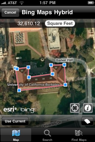
ESRI has had a client for the iPhone for some time now.  Soon they will have one for the Android platform as well.  They had working phones for attendees to use with the ability to do real-time data updates.  There is an API in beta for any ESRI customer to download.  If you're interested please let me know and I can obtain it.  The client software that actually runs on the Android device itself is also in the beta stage but is not yet available to download.   Mobile clients can connect to your own ArcGIS server or to data served by ArcGIS Online hosted by ESRI.

The mobile application allows for collection of data, measuring distances, as well as real-time editing and is intended for general users who do not have to be GIS experts.  The edits are shared right away with others who may be using a mobile or desktop application.  Of course, in many situations users may be in an area without an active cell/data connection.  It's still in various stages of development, but the plans are to have the mobile device cache the appropriate levels of map tiles, data, etc., and then sync with the server upon reconnecting much the same way other applications function when away from cell coverage.

ArcGIS Server Configuration

Web servers are typically configured to accept connections from web browsers on TCP port 80.  Behind the scenes there can be many other servers feeding information on other ports.  Sometimes the other servers can accept direct connections without the web server in the middle.  For a number of reasons, security primarily, these other servers are often behind a firewall and do not accept direct connections from web browsers but do allow connections from the web server.  ArcGIS Server communicates GIS data on port 8399.  Since we generally have not had a need to serve confidential or sensitive data we have always allowed a direct connection to our servers on port 8399.  Recently one of our clients found that their in-house network did not allow connections to port 8399 and no GIS data was appearing in their maps.  Thanks to the help from Brian and Sarah V. we were able to come up with an implementation to allow the end users to connect without problems.  But, it was unclear if this was consistent with the ongoing functionality of ArcGIS Server.

There are a number of ways to configure the web server to accept a connection for ArcGIS Server on port 80 and then go behind the scenes to port 8399.  We have been experiencing various issues during the configuration process as outlined in ESRI and other documentation.  There is a lot of good information available, but it has been in the form of a number of different help articles andconfiguration instructions.  It has been difficult to locate one set of cogent instructions to get things configured start to finish.


Thankfully, I was able to sit down one-on-one with an ESRI technical staff member at the conference. He was able to walk through the process on a demo computer outlining the various steps and explain the process.  I had gotten so far on my own, but he was able to go further showing me the steps real-time.  I will be taking a closer look at how to implement this configuration – which is generally considered to be the "correct" method in lieu of direct connections to port 8399 – in our environment.

ArcGIS Software Updates

Both ArcGIS Server and Desktop will be updated to version 10.1 with an expected release of spring 2012 and a number of functions are to be deprecated.  Of course, the most visible changes are to the Desktop application. 

ArcGIS Server 

  • improved handling of API functions, query requests, and database optimization
  • Web Application Developer Framework (ADF) deprecated
  • rewritten to be 64-bit, 32-bit version deprecated
  • easier set-up
  • integrated printing function
  • improved Linux support
  • ArcIMS deprecated

ArcGIS Desktop 

  • scale bars with dual units (such as miles and kilometers)
  • use of magnetic north as a north arrow
  • coordinate system filtering – those inapplicable  to the current map extent not presented as choices
  • Maplex included for free at all license levels
  • new toolbox tools
  • accept GPS data in GPX format and convert to a layer
  • areal interpolation – for example census tract to ZIP code
  • filtering by time
  • support for LIDAR files in .las format
  • ArcInfo Workstation deprecated (version 10.0 will continue to function)
  • VBA deprecated for new development

ArcGIS Runtime 

  • a new developer tool to distribute with applications
  • no separate installation
  • does not require ArcGIS to be installed
  • small memory requirement, fast processing
  • Windows and Linux, 32- and 64-bit versions
  • mobile version later on, can be used offline

It's clear that ESRI intends to continue enhancing their online functionality.  Much of their effort is going toward making their desktop application more integrated with online data sharing.  There is, of course, the arcgis.com service which is an appealing alternative for those without their own server.  Mobile options are growing and again the emphasis is on real-time sharing and not just data collection with an upload later on.  Right along with their online service is ArcGIS Server which ties together all the various clients and applications for an integrated approach.   Your GIS data is the important focus – the same from desktop to mobile to server – and how you access it is, at best, secondary.  ESRI has shown that they are willing to move forward and recognize today's environment by discontinuing older products such as Web ADF, ArcInfo Workstation, ArcIMS, and so on after having supported them beyond their prime levels of functionality.  Overall the conference was a very positive experience, and I'm quite pleased to have had the opportunity to participate.

Details on ESRI's solar radiation tools

June solar radiation in YellowstoneA nice case study of detailed solar radiation modeling/mapping for Yellowstone National Park. All using existing ESRI spatial analyst tools.

Scientists at the National Aeronautics and Space Administration (NASA) Ames Research Center, including our buddy Chris Potter, the Yellowstone Ecological Research Center (YERC), the Creekside Center for Earth Observation (CCEO), and Esri have created 30-meter solar and temperature distribution maps in mountainous Yellowstone National Forest using tools in the ArcGIS Spatial Analyst extension. These products support ecological management in Yellowstone. 

An overview of ESRI's Solar Radiation Tools can be found here. Go forth and insolate.

New Google SketchUp plug-in integrates 3D laser scan data

Pointools has just announced the availability of a new plug-in for Google SketchUp to be released in a few weeks. This new plug-in will make it easy to visualize and use point cloud data from sources such as mobile ground based scans and aerial lidar for 3D model building in Google SketchUp. The plug-in offers built-in support for Google’s geo-location services to coordinate StreetView textures and aerial imagery alongside point clouds. This new tool allows for a new data source to be used to create photo realistic 3D models of buildings and landscapes.

Click here for the full story and here for a video of the plug-in in action.

Image Source: Pointools Wordpress

QGIS 1.6 'Copiapó' released

The folks working on Quantum GIS (QGIS) have recently released a new version of their popular open source desktop GIS application that works on Windows, Mac, and Linux. 

Version 1.6 can now be downloaded from qgis.org via http://download.qgis.org.

There are a lot of new features and bug fixes in this version, adding even more power to use QGIS as a viable analysis platform.  You can read the entire list of new features here.

Be sure to check out the included analysis plugins for:

  • OGR Converter: Convert between more than 30 vector formats, including shapefile, kml, mapinfo, gpx...
  • Interpolation: Interpolate vector data using Triangular Interpolation (TIN) or Inverse Distance Weighting (IDW)
  • Raster Based Terrain Analysis: Convert DEM data to Slope, Aspect, Ruggedness, or Total Curvature
  • Spatial Query: Topological operations include contains, equals, intersects, touches...
  • GDAL Tools: Adds a new drop down list to your menu that includes many GDAL functions like warp, translate, or contour.  This adds a lot of the power of GDAL without the need to write scripts.
  • fTools: Adds a new dropdown list to your menu with many geoprocessing and analysis functions such as buffers, joins, nearest neighbor, vector grid creation...
  • GRASS: Adds a suite of tools that allow you to use much of the GRASS functionality within the QGIS application

If you are relatively new to GIS, and would like to try QGIS, we've just added an introductory tutorial to the GIF's Quick Start Guides based on this latest software release.  Check out the pdf and accompanying data for Introduction to QGIS: Basic geoprocessing and making a map layout


Clark Labs teams up with Google.org to develop web based land-cover analysis and REDD tools

Land Change Modeler for ArcGIS (Image used with permission from Clark Labs)

From Clark Labs news:

Clark Labs recently received a $451,000 grant from the Gordon and Betty Moore Foundation to support the development of land-cover analysis and REDD tools for use on Google's Earth Engine. REDD, Reducing Emissions from Deforestation and Forest Degradation, is a climate change mitigation strategy that offers developing countries incentives to reduce forest carbon emissions. The complex implementation of REDD relies on substantial computing and data resources, and requires significant effort and investment. It is hoped that providing accessible modeling tools with Google’s cloud computing resources and wealth of geospatial data will encourage broader adoption of REDD.

The grant supports the development of a prototype of the land change analysis and prediction tools for Google.org’s Earth Engine platform, a technology in development that enables global-scale monitoring and measurement of changes in the Earth’s forests. It is planned that Google will host the required geospatial data layers to implement a REDD project, including maps of those factors identified as critical causes of deforestation, such as proximity to roads, slopes or distance from existing deforestation.

The new tools in development will guide the user through the steps of baseline development--land change analysis of the reference, project and leakage areas of a project, the identification of the carbon pools and input of carbon density values, and the estimation of emissions for projected dates. This new functionality will also directly produce the multitude of tables and graphics for the carbon accounting reporting requirement of REDD. The preparation costs of REDD will be significantly reduced by the automation provided by these tools.

Clark Labs is based within the Graduate School of Geography at Clark University in Worcester, MA and is the developer of the IDRISI Taiga GIS and Image Processing software and the Land Change Modeler software extension to ArcGIS. To view the full news release click here.

Definiens Earth Science bought by Trimble

The new company will be called Trimble Geospatial Munich, and maintain the same staff, and the Centers of Excellence Program.  From the Open Letter:

"Definiens’ earth sciences business, including the eCognition suite of products, was acquired on June 10, 2010 by Trimble. The eCognition team has now transferred to Trimble, and the business of delivering the most advanced geospatial analysis software will continue, uninterrupted.

This change represents a significant step forward for eCognition. Access to Trimble’s advanced technologies, expertise and global operations provides us with an exceptional opportunity to take eCognition to a new level. In time, the benefits of the synergies between Trimble and eCognition will become evident through the exciting new product and service innovations we deliver together.

It is also worth noting that the collaboration with Definiens does not end with this transaction. In fact, Definiens and Trimble have signed a co-development agreement to ensure that the core technology driving eCognition continues to evolve and improve, and that there is no pause in the development or release schedule for eCognition."

ArcGIS.com online mapping now available

ESRI has just launched a public beta version of their online mapping service on arcgis.com

At the ArcGIS.com site, you can browse featured ArcGIS Online content such as maps and applications published by ESRI and the ArcGIS community, and add comments and ratings. You can upload and share your own items, either with specific groups that you created or are a member of, or you can share your items publicly. Use the newly designed Web Mapping application to quickly create online mashups that you can also share with others.

The design and interface is nicely done, and includes easy access to many of ESRI's online basemaps.  This site launch coencides with a greatly updated version of ArcGIS Explorer which provides a much improved free GIS viewer, tightly integrated with ArcGIS desktop layers and outputs.


ArcGIS 10 coming in June

The latest ArcGIS release, ArcGIS 10, is slated to become available in June with a lot of big updates.  Check out ESRI's website to see more about what's coming.  They have several informative videos that demo the new software. 

Some of the improvements listed include:

  • Faster display, smoother navigation, and the ability to run geoprocessing in the background.
  • Perform in 3D virtually everything you can do in a 2D environment: modeling, editing, visualization, and analysis.
  • Simplify map creation and production with streamlined sketch-based Desktop (2D/3D) and Web editing.
  • Use and manage imagery more efficiently on the desktop and on the server.
  • New image analysis window for image interpretation and processing.
  • Automate common tasks and analyses with Python scripting.