Wrap up from the FOODIT: Fork to Farm Meeting

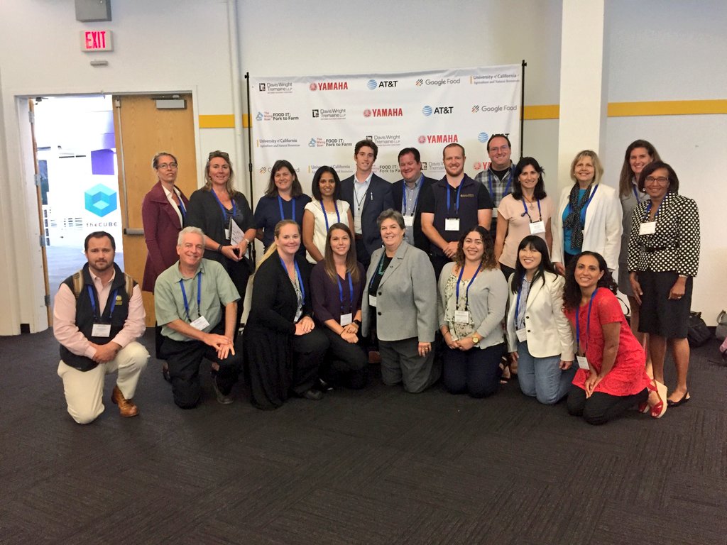
UC ANR was a sponsor for the FOODIT: Fork to Farm meeting in June 2017: http://mixingbowlhub.com/events/food-fork-farm/. Many of us were there to learn about what was happening in the food-data-tech space and learn how UCANR can be of service. It was pretty cool. First, it was held in the Computer History Museum, which is rad. Second, the idea of the day was to link partners, industry, scientists, funders, and foodies, around sustainable food production, distribution, and delivery. Third, there were some rad snacks (pic below). 

We had an initial talk from Mikiel Bakker from Google Food, who have broadened their thinking about food to include not just feeding Googlers, but also the overall food chain and food system sustainability. They have developed 5 "foodshots" (i.e. like "moonshot" thinking): 1) enable individuals to make better choices, 2) shift diets, 3) food system transparency, 4) reduce food losses, and 5) how to make a closed, circular food system.

We then had a series of moderated panels.

The Dean's List introduced a panel of University Deans, moderated by our very own Glenda Humiston @UCANR, and included Helene Dillard (UCDavis), Andy Thulin (CalPoly), Wendy Wintersteen (Iowa State). Key discussion points included lack of food system transparency, science communication and literacy, making money with organics, education and training, farm sustainability and efficiency, market segmentation (e.g. organics), downstream processing, and consumer power to change food systems. Plus the Amazon purchase of Whole Foods.

The Tech-Enabled Consumer session featured 4 speakers from companies who feature tech around food. Katie Finnegan from Walmart, David McIntyre from Airbnb, Barbara Shpizner from Mattson, Michael Wolf from The Spoon. Pretty neat discussion around the way these diverse companies use tech to customize customer experience, provide cost savings, source food, contribute to a better food system. 40% of food waste is in homes, another 40% is in the consumer arena. So much to be done!

The session on Downstream Impacts for the Food Production System featured Chris Chochran from ReFed @refed_nowaste, Sabrina Mutukisna from The Town Kitchen @TheTownKitchen, Kevin Sanchez from the Yolo Food Bank @YoloFoodBank, and Justin Siegel from UC Davis International Innovation and Health. We talked about nutrition for all, schemes for minimizing food waste, waste streams, food banks, distribution of produce and protein to those who need them (@refed_nowaste and @YoloFoodBank), creating high quality jobs for young people of color in the food business (@TheTownKitchen), the amount of energy that is involved in the food system (David Lee from ARPA-E); this means 7% of our energy use in the US inadvertently goes to CREATING FOOD WASTE. Yikes!

The session on Upstream Production Impacts from New Consumer Food Choices featured Ally DeArman from Food Craft Institute @FoodCraftInst, Micke Macrie from Land O' Lakes, Nolan Paul from Driscoll's @driscollsberry, and Kenneth Zuckerberg from Rabobank @Rabobank. This session got cut a bit short, but it was pretty interesting. Especially the Food Craft Institute, whose mission is to help "the small guys" succeed in the food space.

The afternoon sessions included some pitch competitions, deep dive breakouts and networking sessions. What a great day for ANR.

Planet Lab wants YOU to work with their data!

They say: 

Are you a college student, researcher or professor? We’re looking for innovative academics, researchers and scientists to unlock the power of a one-of-a-kind dataset. You can now apply for access to Planet’s unique dataset for non-commercial research purposes. In an area as large as 2,000 square kilometers, you’ll have access to download imagery, analyze trends, and publish your results.

Check it: https://www.planet.com/products/education-and-research/

Planning for the future: core values, mission statements, and strategic thinking

I've been working on two strategic plans for programs and facilities I am directing: GIF and IGIS, and am thinking about what are the key elements in such a plan that communicates clarity, purpose, and mission. The current thinking out there seems to be to think about not just Mission and Vision, but also Core Values. Here is one from ANR that can help me think through my tasks.

ANR Mission, Guiding Principle, and Core Values

Mission

The mission of the University of California Division of Agriculture and Natural Resources is to serve California through the creation, development and application of knowledge in agricultural, natural and human resources.

ANR Guiding Principle

ANR’s research and extension programs serve the public good of California through the creation, development and application of knowledge addressing critical issues in agricultural, natural and related human resources, through a system of community-driven research and outreach programs with CE advisors, CE specialists, and AES scientists supporting each other.

ANR Core Values

  • The highest standards of ethical behavior, honesty and integrity, with the recognition that the trust and confidence of the public is absolutely essential to our success.
  • Academic excellence and maintaining credibility as an objective source of knowledge.
  • Scientifically valid research as a foundation for anticipating problems and developing practical solutions.
  • Responsiveness to state and local needs in California, and consideration of the global context that shapes these needs.
  • Diversity within our organization, equal access to knowledge by all people, and equal opportunity for self-reliance through education.
  • Collaboration, teamwork and mutual respect among ourselves, in partnership with other organizations, and in interaction with our clientele.
  • Academic freedom, with the recognition that individual freedom goes hand in hand with a high standard of professional responsibility and personal accountability to ANR’s land-grant mission.

Cropland Data Layer (CDL) and National Land Cover Dataset (NLCD): new versions released this year

Both the NASS Cropland Data Layer (CDL) and the National Land Cover Dataset (NLCD) released new versions in early 2014. Links for download are here:

Mobile Field Data Collection, Made Easy

Recommendation from Greeninfo Network's MapLines newsletter:

"Attention land trusts, weed mappers, trail maintainers and others - Are you ready for the Spring field work season?  GreenInfo recommends using this customizable, free app for collecting data in the field - Fulcrum App, which offers a free single user plan for storing up to 100 mb of data."

According to their website, with Fulcrum, you build apps to your specifications, allowing you to control exactly what data is captured from the field and how. Maintain high standards of quality to minimize rework, QA/QC, and error correction by getting it done right the first time.

PROBA-V satellite launched May 7

Proba-V’s first image of FranceI haven't used PROBA imagery, but many colleagues in Europe rely on this sensor.

PROBA-V (i.e. "vegetation") was launched May 7. The miniature satellite is designed to map land cover and vegetation growth across the entire planet every two days. The data can be used for alerting authorities to crop failures or monitoring the spread of deserts and deforestation.

Less than a cubic metre in volume, Proba-V is a miniaturised ESA satellite tasked with a full-scale mission: to map land cover and vegetation growth across the entire planet every two days.

Proba-V is flying a lighter but fully functional redesign of the Vegetation imaging instruments previously flown aboard France’s full-sized Spot-4 and Spot-5 satellites, which have been observing Earth since 1998.

Check it out: http://www.esa.int/Our_Activities/Technology/Proba_Missions/Proba-V_opens_its_eyes

ANR Statewide Program on GIS

Mission Statement: IGIS aims to support high-priority programs to advance research and extension projects that enhance agricultural productivity, natural resource conservation and healthy communities into the future by providing Informatics and Geospatial Information Systems tools and applications.

ANR Recently announced the development of a new Statewide Program called the Informatics and GIS (IGIS) program. The new program aims to over the next five years become the nexus for ANR’s rich and diverse geospatial and ecological data, research information, and resources for academics and the public who rely on geospatial and informatics data, analysis and display.  Through data capture, information sharing, and collaboration, we aim to increase our ability to make meaningful predictions of the agricultural, ecosystem, and community response to future change, to increase our understanding of California’s diverse natural, agricultural and human resources, and to support research and outreach projects that enhance agricultural productivity, natural resource conservation and healthy communities into the future.

The IGIS team needs your input to design this resource to be an efficient and helpful delivery of information and GIS support. If you are affiliated with ANR, please take a few minutes to complete the Survey of Informatics and GIS Needs, Knowledge and Data Availability.  This is a short and comprehensive survey that will assess GIS, data and information needs, evaluate your level of informatics and GIS expertise and use of geospatial tools and data.  Your response will be of great assistance toward building a successful State-wide program.

SNAMP feature in Cal Ag

A nice article about SNAMP is now in the recent version of California Agriculture.  In the same edition is a great series of articles about the 150 anniversary of the Morrill Land-Grant College Act which made higher education available to those in every social class, and brought practical information to a nation that was then more than 50% farmers. Cooperative Extension was born with this Act, and it continues to evolve today. A summary by Janet L. White is here.

California Agriculture 66(2):39-39. DOI: 10.3733/ca.v066n02p39a. April-June 2012.

In 1862, in a nation torn by secession and Civil War, President Abraham Lincoln signed a visionary law that laid the cornerstone of public higher education. The Morrill Land-Grant College Act gave federal public lands to states, allotting 30,000 acres for each Senator and Representative. The total endowment was $7.55 million, then the value of 17.4 million acres. Today, more than 100 land-grant universities serve the nation and the world, including what many believe is the greatest public university in the world, the University of California.

On the 150th anniversary of its passage, we pay tribute to this profoundly democratic law, which made higher education available to those in every social class, and brought practical information to a nation that was then more than 50% farmers. It was followed by other landmark education laws: the 1887 Hatch Act, establishing Agricultural Experiment Stations at universities; a second Morrill Act in 1890, initiating regular funding; the Smith-Lever Act of 1914, establishing Cooperative Extension; and in 1944, the GI Bill. Today, UC's land-grant university thrives as the Agricultural Experiment Stations at UC Berkeley, Davis and Riverside, and in UC Cooperative Extension offices that serve every county.

See see pages 40 to 49 for special coverage of the Morrill Act and its role in building the University of California.

Farm surveillance for subsidy checking: the case in Europe

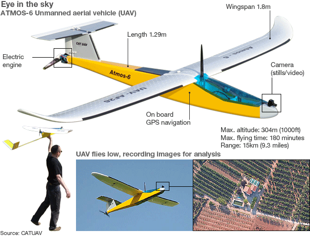
Europe's farmers receive payments for maintaining basic standards on the environment, food safety, plant health and animal welfare. In this BBC article "spying on Europe’s farms with satellites and drones" Lawrence Peter discusses the use of UAVs in conjunction with satellite imagery to validate and verify farmers' subsidies without having to send inspectors in person. They are not used everywhere: Austria does not use them, on the grounds that the shadows cast by very mountainous terrain sometimes make satellite images inaccurate. And Scotland, unlike the rest of the UK, decided against satellites because of the difficulty of getting enough clear weather for flyovers.

Notes: 

  • Agriculture accounted for 42% of the EU's budget in 2011 - about three-quarters of that went on direct payments to farmers, totalling 44bn euros (£37bn; $58bn)
  • In each EU country, at least 5% of farms must be inspected every year - and many check more than 5%
  • Satellites carried out about 70% of all inspections in 2010
  • Growth of satellite monitoring has cut number of infringements
  • EU officials say fraud accounts for only a small fraction of the irregularities - in most cases farmers overclaim because of a miscalculation