Landscape as palimpsest

I am reading a fascinating book this January (xmas gift from the parents) by Jonathan Raban called Driving Home: An American Journey. He is a wonderful writer, and in the introduction he discusses his love of reading, travel and landscapes. He puts all of these into a kind of analytical framework, and discusses how one can observe and consider writing, language, and landscapes as a way to better understand people, context, place and history. Consider this marvelous paragraph:

Trying to understand the habitat in which we live requires an ability to read it - and not just in a loose metaphorical sense. Every inhabited landscape is a palimpsest (this is me now: what an awesome word! see below for definition), its original parchment nearly blackened with the cross-hatching of successive generations of authors, claiming this place as their own and imposing their designs on it, as if their temporary interpretations would stand forever. Later overwriting has obscured all but a few, incompletely erased fragments of the earliest entries on the land, but one can still pick out a phrase here, a word there, and see how the most recently dried layer is already being partially effased with fresh ink.

From wikipedia: A palimpsest is a manuscript page from a scroll or book from which the text has been scraped off and which can be used again. I had not heard of its used as a metaphor for a landscape before, but I like it!
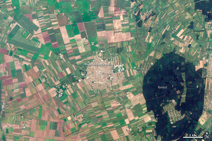
Hajdúböszörmény, Hungary. LandsatYesterday this NASA image post came across my screen as a fitting example of what Raban is talking about. In the  text that accompanies the image, they say "The history of Hajdúböszörmény, Hungary, echoes across its name and over its outline on the land." They go on to discuss the derivation of its name, which echoes past conflicts and local economy, and show how its history is written on the land, in layers of land use. 

"The city is round, a shape easily defended on the flat North Pannonian Plain in northeastern Hungary. The livestock-based economy may also play a role in the shape of the city. The center is densely built, a concentrated ellipse of tan and white. Surrounding the center is a slightly less dense circle, marked by diagonal roads, which held stockyards and gardens. Even today, tiny spots of green indicate that this area contains more open garden space than the city center."

Hooray for geography, landscape history and remote sensing. All fascinating subjects to study. And, I recently found this blogpost from Tim DeChant, former grad student and honorary geographer, in which he describes "ghosts of geography".
Wetland restoration reduces sea level rise impacts over next 100 years in the SF Bay

sun setting on bay marshA new study led by Diana Stralberg at PRBO Conservation Science and including work done by our own Lisa Schile, projects a bleak future for San Francisco Bay’s tidal marshes under high-end sea-level rise scenarios that are increasingly likely. PRBO and colleagues found that in the worst case scenario 93% of San Francisco Bay's tidal marsh could be lost in the next 50-100 years (with 5.4 feet or 1.65 meters of sea-level rise, low sediment availability and no significant restoration). Not all marshes will be lost and restoration currently underway can keep more marshes intact as sea levels rise.

"Tidal marshes are incredibly resilient to changes in sea level, depending on how fast seas rise and how much sediment is available.  Unfortunately, marshes cannot keep up with the high-end sea-level rise predictions on their own.  They will need our help.” said Diana Stralberg, the study lead author of PRBO and the University of Alberta.

Our study was published this week in the high-impact journal PLoS ONE. To view maps of where the marshes will be under various scenarios over the next 100 years, visit www.prbo.org/sfbayslr. News coverage from SF Chronicle here. CNR coverage here.

New evidence of indirect land use change from biofuel production in Brazil

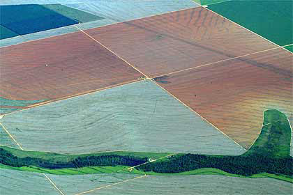
Querência, in Mato Grosso, BrazilA new article in Environmental Research Letters “Statistical confirmation of indirect land use change in the Brazilian Amazon," looks at how mechanized agriculture in Brazil affects the country's forest in the Amazon, which is the second largest forest in the world. The article is authored by Marcelus Caldas, an assistant professor of geography at K-State, and colleagues Eugenio Arima from the University of Texas at Austin, and Peter Richards and Robert Walker from Michigan State University. Using data from 2003-2008, the team statistically linked the loss of forest area as the indirect effect of changing pastureland into space for soybean and biofuel crops in counties bordering the Amazon.

Marcelus Caldas, an assistant professor of geography at K-State says: "Between 2003-2008 soy production expanded in Brazil by 39,000 square kilometers. Of this 39,000 square kilometers, our study shows that reducing soybean production by 10 percent in these pasture areas could decrease deforestation in heavily forested counties of the Brazilian Amazon by almost 26,000 square kilometers -- or 40 percent."

The Brazilian government says soybean and sugarcane are grown largely in degraded pasture, but data from the team's spatial analysis work cascading impacts: many of these crops have crept into the Brazilian savanna, a large area bordering the Amazon that's used for cattle. Consequently, this has created deforestation in the savanna, driving cattle inside the Amazon.

"Our data shows that the Amazon now has 79 million heads of cattle," Caldas said. "Fifteen years ago, it had less than 10 million. That means that there's a problem with cattle moving inside the forest."

This could be exacerbated with increased global demand for food crops in Brazil. The tradeoffs between food, fuel and forest could continue to come down on the side of food and fuel, at the expense of forests.

More here. Official press release here.

ANR Land Use Change workgroup website

Changing land use is one of the most important issues facing California. ANR programs and personnel can help decision makers and land owners make land use decisions that benefit agricultural, natural, and human resources. Our focal areas include land use change, water quality and watershed management, habitat conservation, preservation of working landscapes, and managing growth. This workgroup provides ANR resources to interested clientele. We also identify gaps in our existing knowledge and in our extension materials and work to fill these gaps. We increase communication among our various members and collaborators, both within and beyond DANR and UC. Please see our Land use change website.