Interesting sources of data for science: commerce and construction for ecological trend analysis

In the early 1800s, Canadian fur traders began to notice dramatic fluctuations in snowshoe hare (Lepus americanus) and Canadian lynx populations (Lynx canadensis). Almost 100 years later, ecological researchers were able to use pelt sale data generated by the Hudson’s Bay Company to document an interrelated rise and fall in hare and lynx populations. Today, we understand even more about this classic and frequently cited example of predator–prey cycles, and have identified large-scale factors, including climate, as playing an important role in regulating these populations and their interactions. But it was the novel use of commercial records that got scientists started on their work. This piece excerpted from our article on webGIS.

Now, in the same spirit, comes this article in PERS recently, and it prompted me to start collecting studies on interesting and non-traditional sources of data for hinting at or validating ecological trends. Download Full Article (members only)

The article: Wal-Mart from Space: A New Source for Land Cover Change Validation by Potere et al. The authors use the location and opening dates for 3,043 Wal-Mart stores as a means for validating land-cover change-related products at medium (28.5 m) to coarse (250 m to 1 km) resolutions throughout the conterminous United States. Since Wal-Marts are large, nearly everywhere, and have been built throughout the remote sensing record (1962 to 2004), they prove to be good data set for examining land cover change. A very interesting and creative approach.

Science Editor-in-Chief

I know this is late: blame my routine end-of-semester office paper clean-up (late again). This comes from last year, when Bruce Alberts took over Science. He says in his first editorial: New science will be needed on our crowded planet to protect our environment, to insure our health, and to provide sufficient water and food for humanity.  I think that is true, and sounds a lot like the CNR's mission statement.

Sudden Oak Death Science Symposium Highlights

I thought I'd post some highlights from the SOD Science Symposium, currently running in Scotts Valley, CA.

Dave Rizzo presented new disease information since the first isolations (9 years ago this week!) in 2000 to today. Some highlights include:

  • Across California, there has been filling in of existing areas of the disease, but new areas of confirmation of note:
    • furthest north in CA is 45 miles north of Redway, CA; confirmed from stream baiting, and is associated with a nursery. No terrestrial confirmations. In Mendocino, another river baiting example north of Fort Bragg; no terrestrial confirmations.
  • There are some exciting management projects ongoing, from preventative treatment to large-scale management.

Alan Kanaskie talked about the Oregon situation. Highlights include:

  • Tanoak is critical for SOD in Oregon;
  • Monitoring in OR depends on aerial surveys, field surveys and stream baiting. With these methods, they are confident that ramorum only exists in the known quarantine area. However, they are getting rare PCR confirmations out of steam baiting in new watersheds, but they have not been able to replicate with culture, nor have they found any newly infected trees in those watersheds.
  • They are confident their management approach is working to slow the spread, and compares a map of Humboldt and Curry counties; in Humboldt, things look worse than in Curry.

Sandra Denman from Forest Research in UK gave an update on Pr in Europe: still mainly a nursery problem, but some interesting facts include:

  • Coutries reporting Pr in Europe in 2000 were few, and only 4 countries had outdoor outbreaks; in 2008: 19 countries report Pr in nurseries, and "burgeoning" reports of outdoor outbreaks across western and southern europe.
  • In the UK, Pr has been found in 600 nurseries in UK. In outdoor outbreaks, rhodies are the main problem, and outside outbreaks on trees are associated with these ornamentals.
  • First use of "kerfuffel" in a science presentation that I have heard.
  • P. kernoviae is also important in UK; and last year Pk was found in the Republic of Ireland for the first time.

Clive Brasier, from UK Forestry Commission, talked about P species and increased invasions due to international trade, and weak international biosecurity. Before 2000, about 20% of P sp were threats to forests; since 2000 (with 50+ new P species named), about 60% are threats to trees and forests. He guesses there might be 100-500 unnamed P. species out there that could be invasive in forests. They are now hypothesizing that Pr came from Japan and/or Taiwan.

For more on Sudden Oak Death, check out the OakMapper site, and other oakmapper posts on this blog.

OakMapper 2.0 released

Hi y'all. The new OakMapper 2.0 is up and running, and we'd like your help in mapping areas of oak mortality around the state. Version 2.0 improves upon the website's prior version with increased functionality and additional tools within an easily navigated interface.  Launched by the UC Berkeley Kelly lab in October, OakMapper 2.0 makes it easier for users to explore data, download maps, look at images of oak mortality, and submit suspected locations of oak mortality that may be associated with SOD.  The new interface utilizes the familiar background layers and navigation tools from Google Maps.  Users are able to draw points and polygons directly on the map as well as attach photos to specific points.  The Kelly lab encourages the public to use this site to map suspected cases of SOD and to track their submission by signing up for an account with OakMapper.  Registered users of the site can update their information and make comments on other users' points.  Official confirmations of P. ramorum are clearly separated from community-submitted points and either set of points can be filtered out.The new OakMapper is found at oakmapper.org.  Please consider signing up to be an OakMapper user! The OakMapper was recently featured in the recent journal of the Bay Area Automated Mapping Association

.

Pollan is at it again

By "it" I mean brilliantly explaining the food situation. Read his Open Letter to the Next President from Sunday's NYTimes; and listen to him on Fresh Air (10-20-08 podcast).  He touches on everything we talked about in lab meeting last week - ethanol, cheap calories, obesity, GHG, growing biofuels on prime agricultural land, farmer's disincentives to grow food. This guy is amazing.

FANTASTIC Bay Area spatial data

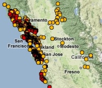
  If you love detailed spatial data and/or the bay area, I HIGHLY recommend downloading and exploring the readily available Upland Goals Project Data . Ryan Branciforte introduced  it to us last week during his enlightening geolunch presentation about his work with the Bay Area Open Space Council. There is a wealth of data for all interests, including vegetation, animals, environmental features, weather patterns, fire risk, and even camp sites if you want to plan a trip to go look at all the data on the ground.

SNAMP news

  Appeals court stops feds plan to log Sierra Nevada forest - The Associated Press /Published 11:37 am PDT Wednesday, May 14, 2008/ A federal appeals court has barred logging in the Sierra Nevada forest. The 9th U.S. Circuit Court of Appeals says the federal government failed to explore other ways to raise money to fight forest fires when it approved a plan to award timber contracts to cut down trees on three sites. The Forest Service says the logging of commercially valuable trees is needed to help pay for thinning of less desirable smaller trees and brush. Environmental groups say the logging plan fails to protect scarce species such as the California spotted owl, martin and Pacific fisher. Attorney General Jerry Brown joined the environmental groups in appealing a lower court decision last year that authorized the government to allow the timber contracts. We'll keep you posted.

“Lonely Planet” Article in the Washington Post

There is an article in the WashPost article today, spurred by the MODIS images of the southern California fires. It is interesting to see these MODIS images used so widely for what I think is the first time. The reporter gives his own take on an overview from the first satellites to Google Earth, and ends by saying that these technologies have allowed us to develop a "sense of the Earth as a whole." Not sure I agree, but an interesting take.