Debris from Japanese tsunami steadily drifting toward California

This item got heavy news rotation this morning: the considerable debris from the tsunami in Japan is out to sea and slowly moving toward Hawaii and the west coast of the US. 

The debris is moving east at roughly 10 miles a day, and is spread over an area about 350 miles wide and 1,300 miles long -- an area roughly the size of California. It should reach beaches and coastal cities in California, Oregon and Washington in 2013 or early 2014. These estimates are from a computer model, the details of which are spotty in the articles I read. Example here from insidebayarea.
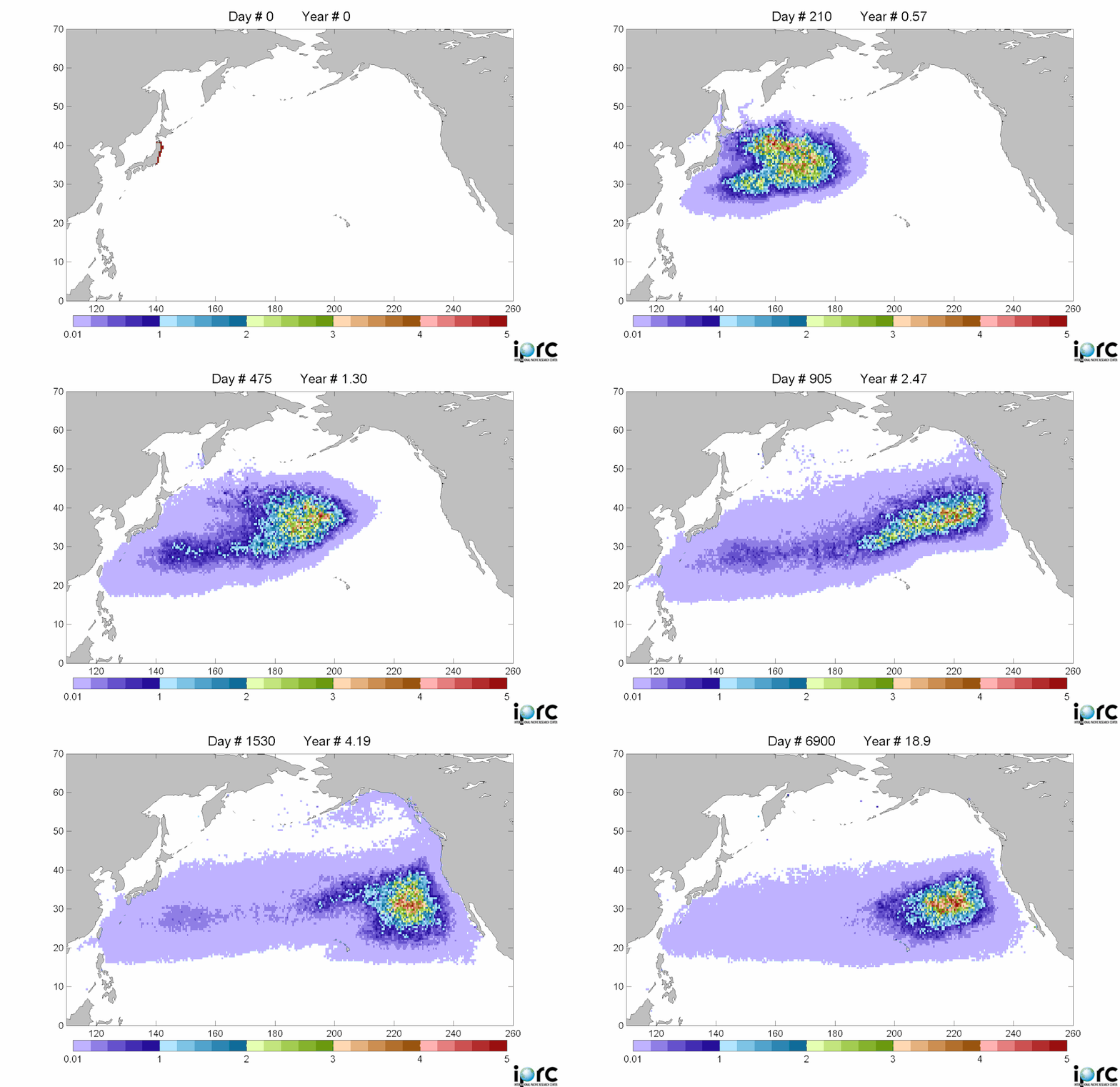
Debris movement similation: purple is low density, red is high density of debrisThere is considerable concern about this.  Last Monday, representatives from the Coast Guard, NOAA, the Environmental Protection Agency, the U.S. State Department and other agencies met for the first time in Honolulu to share information about the Japanese debris and begin to chart a strategy.

Among their plans: to notify the U.S. Navy and commercial shipping companies that regularly sail across the Pacific so they can begin to document what is floating. That could lead to expeditions to go map and study it.

Curtis Ebbesmeyer, a Seattle oceanographer who has studied marine debris for more than 20 years (and done some neat work with rubber duckies to map ocean currents) is one of the leads interviewed for the report.
 

Sacramento - vulnerable to levee breaks

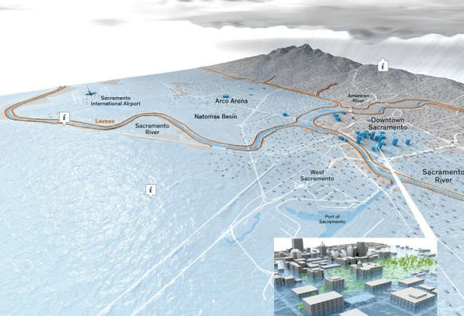
Sacramento's levee system: levees are in orange, the inset is the capital under floodwaters.A good article from NYTimes discussing the vulnerability of Sacramento to levee breaks. Scientists consider Sacramento — which sits at the confluence of the Sacramento and American Rivers and near the delta — the most flood-prone city in the nation. The city is at risk from earthquake-damaged levees and storm related flooding.

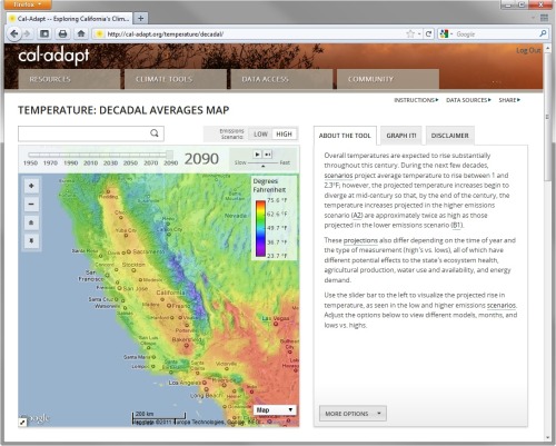
Cal-adapt goes live: making California climate change data available to all

California - 2090 - Annual Average Temperature - High EmissionsThe exciting project the GIF staff have been working on for 9 months is ready to be revealed. Cal-Adapt is a web-based climate adaptation planning tool that will help local governments respond to climate change. The site was developed by UC Berkeley’s Geospatial Innovation Facility with funding and oversight from the California Energy Commission’s Public Interest Energy Research Program. The information for Cal-Adapt was gathered from California’s scientific community and represents the most current data available.


“Cal-Adapt will allow people to identify climate change risks in specific areas around the state.” said Secretary for Natural Resources, John Laird. “This tool will be especially beneficial to government agencies and city and county planners, as they will now have access to climate change information in a very user-friendly application.”


UC Berkeley press release.

ESRI's ChangeMatters and New Landsat Image Services

Yesterday at the annual ASPRS conference in Milwaukee, WI (yes there were sausages shaped like the state), Jack Dangermond announced the release of ChangeMatters, and new Landsat Image Services from ESRI.

ChangeMatters. Working with partners, ESRI developed this web application - ChangeMatters - which allows users throughout the globe to quickly view the GLS Landsat imagery both multi-spectrally (in different Landsat band combinations) and multi-temporally (across epochs), and to conduct simple change detection analysis.

Image Services, with examples of vegetation, false color, land-water band combinations in seamless, color matched Landsat mosaics. Downloads will be available soon. Pretty nice. Website.

Example from ChangeMatters: Las Vegas from 1975 - 2000. Green is increase and red decrease in veg


Growth in geospatial jobs & need for training

The market for geospatial technologies is growing at about 35% a year, studies suggest, and the geospatial industry as a whole is expected to add at least 330,000 jobs between 2008 and 2018, claims recent article in Directions Magazine.

Summary: In this article, Becky Shumate, GISP, discusses the definition of the GIS profession, as well as its potential growth. She cites the Geospatial Workforce Development Center's work, as well as the Department of Labor's Employment and Training Administration's recently concluded study of the field's potential growth.

Of note: the Dept. of Labor's Employment and Training Administration (ETA) tagged Geospatial Technologies as a "High Growth Industry" in March of 2010. They estimated that the geospatial technology profession will experience a growth of over 330,000 geospatial professionals between 2008 and 2018. This growth figure would bring the number of geospatial professionals to just under 1.2 million and is supported by similar estimates by other geospatial organizations. As quoted by the Geospatial Information & Technology Association (GITA), "uses for geospatial technology are so widespread and diverse, the market is growing at an annual rate of almost 35 percent, with the commercial subsection of the market expanding at the rate of 100 percent each year. "

Here is the report: http://www.careeronestop.org/competencymodel/pyramid.aspx?GEO=Y

New BAAMA Journal Published

Volume 5, Issue 1 - Spring 2011

BAAMA is pleased to announce The BAAMA Journal has been published in conjunction with Earth Day.  Special thanks to all our contributing authors and editors.  The BAAMA Journal is a publication that highlights Bay Area people and projects that use geospatial technologies.

IN THIS ISSUE:

  • Building Virtual San Francisco: Growing Up With GIS
  • DPW Uses LiDAR and a Custom Algorithm for Delineating Drainage Catchments and Hydrologic Modeling
  • Preparing Historical Aerial Imagery of Southern California Deserts for use in LADWP's GIS
  • Where in the Bay Area


London Mapping Festival: 18 months of all things maps + london. Sign me up.

The London Mapping Festival 2011 – 2012, or LMF for short, is an exciting and unique initiative being launched in June 2011 and will run through to December 2012. It sets out to promote greater awareness and understanding of how maps and digital geographic data are being created and used within the Capital.   Through a diverse range of activities LMF will engage with a wide audience of mapping enthusiasts whether they are professionals, enthusiasts or others. We should do something like this for the SF Bay Area. More here.

A personal note: "Berkeley class recalls integration 41 years later"

The only tenuous connection to mapping in this story is that it was in Mrs. Room's class I first fell in love with maps. She had us do an elaborate field mapping project in the school's gardens with hula hoops and such, in kindergarten. One day I will find the result and scan it.

This article from SF Chronicle is about our recent reunion at John Muir School in Berkeley.

Forty-one years ago, in the early days of forced integration, a small group of Berkeley schoolchildren were placed in an experimental class and held together from kindergarten through third grade with the same teacher. On Sunday, they came back to see each other again - and to reminisce about what they saw as an idyllic time. Read more: http://www.sfgate.com/cgi-bin/article.cgi?f=/c/a/2011/04/10/BAP91ITSUD.DTL#ixzz1JFTvtD7e

Apps for Oak Trees: Can social media help save a forest?

From the East Bay Express: a nice article by Caitlin Esch about mobile apps, citizen science and environmental science. The article features the OakMapper, and ken-ichi ueda's iNaturalist, and UC Davis' Roadkill Observation System. The article includes a nice history of the OakMapper, including our early days wrangling faxes and hand-drawn maps, and the early inspiration for the site: the USGS Earthquake Mapper.

21st century maps are commercial products, not national efforts

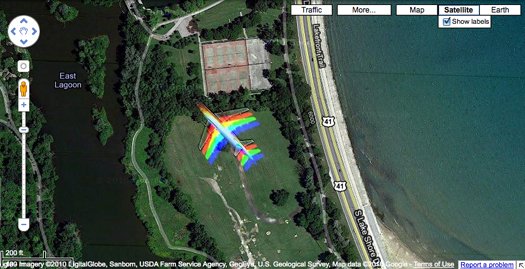
From the Map Room. Popsci has an interesting article about "how digital maps are changing the landscape of the 21st century". Among the interesting bits is this RAD image, showing a moving plane captured by the GeoEye satellite. But the main argument is that mapping used to be the purview of nations and international bodies, but now commercial entities like Google, Bing, Mapquest, and other digital services are the principal mapmakers of the 21st century. Now, maps are commercial products, compiled from a variety of sources that often blend government-derived mapping data with user-generated content. The article suggests they are subject to conflicting information, differences of political opinion and outright error. In addition, the article claims we haven't really focused on this transfer of cartographic power, but of course many have commented on this (e.g. Goodchild's VGI article frfom 2007 in Geojournal) in the academic world.

Visualizing slavery from 1860

From the NYT comes a great article about an early map from the US Coast Survey (creators of those lovely coastal charts from the late 19th century that adorn many of my walls) that shows slavery in the southern US, based on the 1860 census. The map used novel cartographic techniques for the day and was a masterful piece of public outreach: it was important in convincing the Union public that the civil war was about slavery, and not just state's rights. Map here.

From the article: 

The 1860 Census was the last time the federal government took a count of the South’s vast slave population. Several months later, the United States Coast Survey—arguably the most important scientific agency in the nation at the time—issued two maps of slavery that drew on the Census data, the first of Virginia and the second of Southern states as a whole. Though many Americans knew that dependence on slave labor varied throughout the South, these maps uniquely captured the complexity of the institution and struck a chord with a public hungry for information about the rebellion.

The map uses what was then a new technique in statistical cartography: Each county not only displays its slave population numerically, but is shaded (the darker the shading, the higher the number of slaves) to visualize the concentration of slavery across the region (legend at left). The counties along the Mississippi River and in coastal South Carolina are almost black, while Kentucky and the Appalachians are nearly white.

Researching why animals move across the land

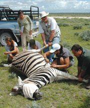
Collaring a zebraA very nice article about Wayne Getz's research in Africa: spatial ecology, epidemiology, conservation and citizen science. From Breakthroughs Magazine

In this article he talks about his evolution as a scientist from mathematician to geo-nerd. The article states: At the core of Getz’s work is how and why animals move across the land. People have sought answers to these questions for time immemorial - at first to improve success in the hunt and harvest, and much later to understand animals in and of themselves. His approach combines a mathematician’s genius for analysis with hands-on wildlife research. This unique perspective is revealing that animal travel patterns can provide a great number of insights into animal behavior, ecology, and epidemiology.

And now the GIS part: In recent years, the advent of global positioning system technologies, coupled with expanded telecommunications networks, have added up to a revolution in animal tracking. The modern version of the radio collar can map an animal’s position to within a couple of meters every few minutes, upload the stored data automatically to a satellite or cell phone network, and allow biologists to track the beast from afar for many weeks. 

Also read about his work in education and social justice in South Africa. Cool stuff. Check it.

The future is already here – it's just not evenly distributed. Or maybe it is.

William Gibson (yes that one) in the NYTimes Opinion page, writes about Google, and the way it has changed how we interact with information and the world. It is a really interesting article touching on human choice, surveillance, and the catch-up game the law plays with technology. This visionary author of Neuromancer says "Science fiction never imagined Google..." and goes on to describe its omipresence, our ready participation in this process, and our discomfort at the result. He is a fantastic writer. Check it:

Google is not ours. Which feels confusing, because we are its unpaid content-providers, in one way or another. We generate product for Google, our every search a minuscule contribution. Google is made of us, a sort of coral reef of human minds and their products.

Wow. Here is another example of his engaging and illuminating prose:

Jeremy Bentham’s Panopticon* prison design is a perennial metaphor in discussions of digital surveillance and data mining, but it doesn’t really suit an entity like Google. Bentham’s all-seeing eye looks down from a central viewpoint, the gaze of a Victorian warder. In Google, we are at once the surveilled and the individual retinal cells of the surveillant, however many millions of us, constantly if unconsciously participatory. We are part of a post-geographical, post-national super-state, one that handily says no to China. Or yes, depending on profit considerations and strategy.

The title of this post comes from his oft-cited quote in 2003 in The Economist.

*About the Panopticon from wikipedia: The Panopticon is a type of prison building designed by English philosopher and social theorist Jeremy Bentham in 1785. The concept of the design is to allow an observer to observe (-opticon) all (pan-) prisoners without the incarcerated being able to tell whether they are being watched, thereby conveying what one architect has called the "sentiment of an invisible omniscience."

GIF Open House Today!

Thursday, September 2, 1-3 PM 

111 Mulford Hall

Check out new equipment and find out how mapping technology can enhance your research! 

The Geospatial Innovation Facility (http://gif.berkeley.edu) will be hosting an open house on Thursday, September 2 at 1PM.  Meet UC students, faculty, and staff who are interested in geospatial applications, and learn how the GIF can help you to utilize technologies including GIS, GPS, Remote Sensing, WebGIS, and 3D Visualization. 

Root beer floats will be available while supplies last!

Everyone should listen to today's Fresh Air interview

Not directly map related, but might be. As I sit here with three screens, email open, working on multiple projects, including upcoming semester's lectures, AND listening to today's Fresh Air, I am struck dumb. In this interview, in which dear old Terry Gross reveals her late nite email addiction (et tu Terry?), the guest Matt Richtel (NTimes) reveals the answers to the following questions (and many more): Why is email addicting? Are there downsides to our constant focus on multiple influxes of infomation? What are the psycological and neurological underpinnings to this madness? The answers involve dopamine, stress hormones, declining capacity to concentrate and create, and a whole lot of scary.

Are there parallels or lessons for us in our deluge of map-related technology and data? Yikes!

GIScience added to federal list of STEM disciplines

ICE announces expanded list of science, technology, engineering, and math degree programs Qualifies eligible graduates to extend their post-graduate training

WASHINGTON-U.S. Immigration and Customs Enforcement (ICE) today published an expanded list of science, technology, engineering, and math (STEM) degree programs that qualify eligible graduates on student visas for an Optional Practical Training (OPT) extension-an important step forward in the Obama administration's continued commitment to fixing our broken immigration system and expanding access to the nation's pool of talented high skilled graduates in the science and technology fields.

The announcement follows President Obama's recent remarks in El Paso, Texas, where he reiterated his strong support for new policies that embrace talented students from other countries, who enrich the nation by working in science and technology jobs and fueling innovation in their chosen fields here in the United States, as a part of comprehensive reform. 

By expanding the list of STEM degrees to include such fields as Neuroscience, Medical Informatics, Pharmaceutics and Drug Design, Mathematics and Computer Science, the Obama administration is helping to address shortages in certain high tech sectors of talented scientists and technology experts-permitting highly skilled foreign graduates who wish to work in their field of study upon graduation and extend their post-graduate training in the United States.

Under the OPT program, foreign students who graduate from U.S. colleges and universities are able to remain in the U.S. and receive training through work experience for up to 12 months. Students who graduate with one of the newly-expanded STEM degrees can remain for an additional 17 months on an OPT STEM extension. More here.