Maps as Media: Map making in the 21st century

Today's "On the Media" radio show included a great discussion of maps and map making in the Google era. Largely a synopsis of this article in the Washington Monthly by John Gravois, the radio piece, with John Gravois, touched on the decline of the National Map and the rise of the Google Map paradigm, and the consequences of this change: how does Google name features that are in dispute? what do maps mean as their lineage changes from government to corporation? how do the political nuances of national maps change as Google becomes the global standard for map making? do we need a new term for these increasingly community based collections of spatially tagged conversations? It was a really interesting piece, and I recommend it. Good listening.

Definiens Earth Science bought by Trimble

The new company will be called Trimble Geospatial Munich, and maintain the same staff, and the Centers of Excellence Program.  From the Open Letter:

"Definiens’ earth sciences business, including the eCognition suite of products, was acquired on June 10, 2010 by Trimble. The eCognition team has now transferred to Trimble, and the business of delivering the most advanced geospatial analysis software will continue, uninterrupted.

This change represents a significant step forward for eCognition. Access to Trimble’s advanced technologies, expertise and global operations provides us with an exceptional opportunity to take eCognition to a new level. In time, the benefits of the synergies between Trimble and eCognition will become evident through the exciting new product and service innovations we deliver together.

It is also worth noting that the collaboration with Definiens does not end with this transaction. In fact, Definiens and Trimble have signed a co-development agreement to ensure that the core technology driving eCognition continues to evolve and improve, and that there is no pause in the development or release schedule for eCognition."

First in new fleet of GPS satellites launches May 27, finally

The GPS IIF artworkMay is a big month for GPS. Ten years ago selective availability of GPS signals was disabled, making accurate GPS technology available to the public rather than just the U.S. military. Boy was field work hard back then - all that map reading!

And this week the Air Force will launch the first of the next generation of GPS satellites - the IIF SV-1. The new satellites each transmit three civilian GPS signals — we’ve typically been making do with just one for years — including a military-strength transmission that should enable autopilots to land with zero visibility. This means always-on GPS that’s accurate to within 3 feet, even indoors and in concrete urban canyons. From Wired.

According to the launch material, each IIF satellite will deliver:

  • Two times greater predicted signal accuracy than heritage satellites;
  • New L5 signals for more robust civil, commercial aviation;
  • Military signal "M-code" and variable power for better resistance to jamming in hostile environments;
  • A 12-year design life providing long-term service and reduced operating costs; and
  • An on-orbit, reprogrammable processor, receiving software uploads for improved system operation.

More information here.

Transit & Trails: Go hiking without a car in the Bay Area

Ryan Branciforte at the Bay Area Open Space Council reports on their new web tool: Transit and Trails. The new interactive website identifies more than 500 trailheads and 150 campgrounds in our region’s 1.2 million acres of preserved lands. Just enter your starting location at Transit and Trails’ Google Maps-powered site, and select the radius. Once you’ve picked your ideal trail from the results, Transit and Trails will open a new link in 511 Transit Trip Planner, where you’ll find a detailed trip itinerary, complete with a map, transit times, fares, and walking directions to and from the transit stop. Very cool.

Related news: from the SF Chron, SF Hostels, mother nature network, & triple pundit.

Year-end comments on self-location technology and privacy

As many in recent academic papers have pointed out (e.g. Sarah Ellwood, Jerry Dobson, Michael Goodchild) we seem, for a number of reasons, to be increasingly comfortable disclosing our location by "opting in" to technology that in addition to being very useful, also allows our surveillance. I am not talking Lucy Milligan-style gps necklaces here, but more common fare: gps-enabled cell phones, street view, cctv cameras and the like.  These technologies and our use of them might be changing our notions of our “reasonable expectations of privacy”. It is perhaps no coincidence that in this season for the media to summarize the year's news, there have been many interesting examples focusing on the interface between privacy and geo-location. Consider these:

  • Along those lines is the much posted recent revelation that Sprint has so far filled over 8 million requests from law enforcement for customer GPS data. Posted at Engaget and elsewhere.

Welcome to 2010, another exciting year in mapping technology no doubt.

geospatial IT specialist needed @ UC Berkeley

The Geospatial Innovation Facility (GIF) at UC Berkeley is seeking a full-time Computer Resource Specialist (CRS II), who has experience in both IT/server support and geospatial programming including ArcGIS Server and Google Maps API development.

The GIF supports research and outreach activities of users interested in geospatial analysis utilizing GIS, GPS, spatial analysis, remote sensing, 3D visualization, and webGIS. We serve the geospatial needs of UC students, faculty, and staff. In addition, the GIF reaches out to K-12 youth groups and the general public.

The GIF Geospatial IT specialist will gain and share experience in the newest geospatial software and technology available on the market today, including state-of-the-art techniques (e.g. object-based image analysis and remote sensing) and software (e.g. open-source GIS and webGIS applications) used in natural resource and social science research.

For more information, see this page. Note, You MUST apply for this job via UC Berkeley’s Jobs Website. Job ID: 10328.

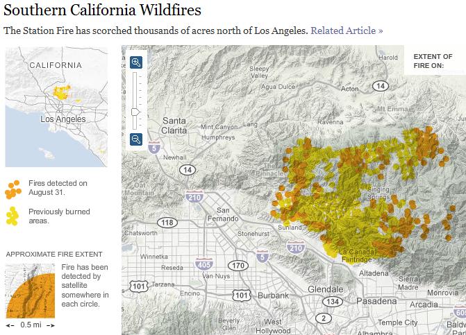
NY Times Interactive Map of SoCal Wildfires

The New York Times has an interesting interactive map displaying the progression of the latest Southern California wildfires over the course the past week. In addition to the rapid spread of the fires, what's interesting is that this map was generated via satellite imagery. (The map legend states that a fire has been detected by satellite within each 0.5 mile buffer displayed). Unfortunately no further details of the source data are offered.

Fall 2009 GIF Geolunch Series Schedule Posted

The fall 2009 Geolunch series at the Geospatial Innovation Facility has been posted!

The GIF and the Museum of Vertebrate Zoology (MVZ) host a weekly GeoLunch seminar series offering interesting talks, group discussion, and show-and-tells - all invloving geospatial theory, research, and application!

GeoLunch occurs throughout the academic year every Friday, 1-2pm at the GIF 111 Mulford Hall Conference Room.

See the schedule here!

Fall 2009 GIF workshop schedule posted

The fall 2009 workshop schedule at berkeley's geospatial innovation facility (GIF) is posted! There are several new workshops scheduled, including:

  • Intro to Geographic Information Systems (GIS): Social Science Focus;
  • Intro to Open Source GIS: Working with Quantum GIS (QGIS);
  • Intro to Agent-Based Modeling: Using GIS data with NetLogo; and
  • Intro to LIDAR applications in Remote Sensing.

Check out the website!

Science Editor-in-Chief

I know this is late: blame my routine end-of-semester office paper clean-up (late again). This comes from last year, when Bruce Alberts took over Science. He says in his first editorial: New science will be needed on our crowded planet to protect our environment, to insure our health, and to provide sufficient water and food for humanity.  I think that is true, and sounds a lot like the CNR's mission statement.

Democratizing Data

The Federal CIO Coucil has just launched Data.gov, a site that brings all federal data into one searchable place. You can directly download xml, csv, kml/kmz, and shp files and find links to tools for finding other data.

Here are some more details from the White House press release:

"Created as part of the President's commitment to open government and democratizing information, Data.gov will open up the workings of government by making economic, healthcare, environmental, and other government information available on a single website, allowing the public to access raw data and transform it in innovative ways.

Such data are currently fragmented across multiple sites and formats—making them hard to use and even harder to access in the first place. Data.gov will change this, by creating a one-stop shop for free access to data generated across all federal agencies. The Data.gov catalog will allow the American people to find, use, and repackage data held and generated by the government, which we hope will result in citizen feedback and new ideas.

Data.gov will also help government agencies—so that taxpayer dollars get spent more wisely and efficiently. Through live data feeds, agencies will have the ability to easily access data both internally and externally from other agencies, which will allow them to maintain higher levels of performance. In the months and years ahead, our goal is to continuously improve and update Data.gov with a wide variety of available datasets and easy-to-use tools based on public feedback and as we modernize legacy systems over time.

Democratizing government data will help change how government operates—and give citizens the ability to participate in making government services more effective, accessible, and transparent."


Tracking people and crime

This article describes how the LAPD online crime map mistakenly geocoded 1,380 crimes to a spot directly in front of the LA Times Office because it was the default location for unmatched geocodes. This mistake then lead to the popular site EveryBlock to rank that ZIP code as one of the most dangerous in the city. Lesson learned: don't believe every dot on a map is the absolute truth.

Another interesting article describes how analysis of an FBI database links long-haul truckers to serial killings. This shows that local data linked together can change the scale of analysis to reveal a "mobile crime scene".

Professor Hoosen, UC Berkeley, Dies

David Hoosen, geographer, Cal Bear and Welshman died while swimming in Tomales Bay. He was one of my professors while at UCB undergrad. He was always interested in my time in Wales and my swimming. This is what his wife said about his field of research: "Geography for David — and I think all geographers — is far more than about location in itself," she said. "It is about the interactions of places and peoples, the interconnections of the physical environment and the human actions on it. Geography is the discipline that integrates these aspects that each may be studied by specialists: it gives the bigger picture." I couldn't have said it better myself. For the full obit: Hoosen Obit.

Free Landsat Imagery

The USGS announced last week that it will be releasing the entire USGS Landsat Archive at No Charge. This was the message: Imagery for Everyone… Timeline Set to Release Entire USGS Landsat Archive at No Charge. RESTON, VA – The USGS Landsat archive is an unequaled 35-year record of the Earth’s surface that is valuable for a broad range of uses, ranging from climate change science to forest management to emergency response, plus countless other user applications. Under a transition toward a National Land Imaging Program sponsored by the Secretary of the Interior, the USGS is pursuing an aggressive schedule to provide users with electronic access to any Landsat scene held in the USGS-managed national archive of global scenes dating back to Landsat 1, launched in 1972. By February 2009, any archive scene selected by a user – with no restriction on cloud cover – will be processed automatically to a standard product recipe, using such parameters as the Universe Transverse Mercator projection, and staged for electronic retrieval. In addition, newly acquired scenes meeting a cloud cover threshold of 20% or below will be processed to the standard recipe and placed on line for at least six months, after which they will remain available for selection from the archive. Newly acquired, minimally cloudy Landsat 7 Enhanced Thematic Mapper Plus (ETM+) data covering North America and Africa are already being distributed by the USGS over the Internet at no charge, with expansion to full global coverage of incoming Landsat 7 data to be completed by July 2008 (see timeline below). The full archive of historical Landsat 7 ETM+ data acquired by the USGS since launch in 1999 will become available for selection and downloading by the end of September 2008. At that time, all Landsat 7 data purchasing options from the USGS, wherein users pay for on-demand processing to various parameters will be discontinued. By the end of December of 2008, both incoming Landsat 5 Thematic Mapper (TM) data and all Landsat 5 TM data acquired by the USGS since launch (1984) will become available, with all Landsat 4 TM (1982-1985) and Landsat 1-5 Multi-Spectral Scanner (MSS) (1972-1994) data becoming available by the end of January 2009. All Landsat data purchasing options from the USGS will be discontinued by February 2009, once the entire Landsat archive can be accessed at no charge. Landsat scenes can be previewed and downloaded using the USGS Global Visualization Viewer at http://glovis.usgs.gov [under “Select Collection” choose Landsat archive: L7 SLC-off (2003-present)]. Scenes can also be selected using the USGS Earth Explorer tool at http://earthexplorer.usgs.gov [under “Select Your Dataset” choose Landsat Archive: L7 SLC-off (2003-present)]. For further information on Landsat satellites and products, see http://landsat.usgs.gov For further information on USGS Land Remote Sensing please visit our website: landremotesensing@usgs.gov USGS Announcement

Google Earth Maps Refugee Crises

GENEVA (AP) -- Internet search giant Google Inc. unveiled a new feature Tuesday for its popular mapping programs that shines a spotlight on the movement of refugees around the world.


art.google.earth.jpg


Users must have downloaded Google Earth, UNHCR maps to access refugee information.

The maps will aid humanitarian operations as well as help inform the public about the millions who have fled their homes because of violence or hardship, according to the office of the U.N. High Commissioner for Refugees, which is working with Google on the project. "All of the things that we do for refugees in the refugee camps around the world will become more visible," U.N. Deputy High Commissioner for Refugees L. Craig Johnstone said at the launch in Geneva. Users can download Google Earth software to see satellite images of refugee hot spots such as Darfur, Iraq and Colombia. Information provided by the U.N. refugee agency explains where the refugees have come from and what problems they face. Although not all parts of the world are displayed at the same high resolution, the Mountain View, Calif.-based company has made an effort to allow users to zoom in closely on refugee camps. In the Djabal refugee camp in eastern Chad, which is home to refugees from the conflict in neighboring Darfur, Google Earth users can see individual tents clustered together amid a sparse landscape, and learn about the difficulty of providing water to some 15,000 people. Google says more than 350 million people have already downloaded Google Earth. The software was launched three years ago and originally intended for highly realistic video games, but its use by rescuers during Hurricane Katrina led the company to reach out to governments and nonprofit organizations. Google Earth has since teamed up with dozens of nonprofit groups seeking to raise awareness, recruit volunteers and encourage donations. Among them are the U.S. Holocaust Memorial Museum, the U.N. Environmental Program and the Jane Goodall Institute. "Google wants to organize the world's information and make it universally accessible and useful," said Samuel Widmann, the head of Google Earth Europe. The company estimates that 80 percent of the world's information can be plotted on a map in some way. Rebecca Moore, who heads the Google Earth Outreach program for nonprofit groups, said the company does not control the information published using the software. Google is considering offering a stand-alone version of its mapping software that can be used by aid workers in the field who do not have an Internet connection on hand, she said. Google said it will also provide nonprofit groups in several countries with training and free copies of its $400 professional mapping software, an offer it plans to roll out across the globe over time. http://www.cnn.com/2008/TECH/04/08/google.refugees.ap/index.html