Apple mobile mapping software? coming soon!

We mac users are all a-twitter about the news of an impending Apple mapping software. Here is a sample from NPR:

There's been speculation for months that Apple will try to elbow Google's popular Maps app aside on the iPhone and unveil its own map app, and some of the best evidence yet comes from Tuesday's Wall Street Journal.  The paper looked into the reasons for the impending switch and the broader implications it would have for the smartphone market.  The article continues...

The new software is rumored to be leaner, meaner, and packing a rad 3D visualization capability. It will be unveiled as soon as next week at the annual Apple developer conference in San Francisco.

Report on the April 19 Careers in GIS event at UC Berkeley

GIS @ Berkeley

Careers in GIS

On April 19 the College of Natural Resources and the College of Environmental Design held an informative workshop on Careers in GIS.  This workshop covered many aspects of Geographic Information Sciences: resources on the Berkeley campus, options for the new Minor in Geographic Information Science and Technology, and highlighted areas of GIS research.  Over 40 people attended, and we had a lively program, including a welcome from Jennifer Wolch (Dean of CED), Doug Richardson (Executive Director of the AAG), Maggi Kelly (Professor in ESPM); Scott Stephens (Professor in ESPM) talked about his work using GIS and spatial data for forest fire modeling, Mei-Po Kwan (Visiting Professor in Geography) discussed GIS Analysis for transportation and health studies, highlighting some of her fascinating work in spatial-temporal analysis of human movement; and Paul Waddell (Professor in CRP) showed highlights of his GIS and urban mapping, including UrbanSim, a very novel open source approach to city planning and accessibility studies. In addition, Jon Ridener from the Earth Sciences and Map Library discussed the GeoData@UCBerkeley, a GIS data portal and repository created by the UC Berkeley Library. Wow! All great stuff.

The event was brought to you by: College of Natural Resources, College of Environmental Design, Geospatial Innovation Facility. For more information on GIS at Berkeley, please see the GIS @ Berkeley website.

Follow up on Supreme Court gps+privacy case

From the NYTimes. Police Are Using Phone Tracking as a Routine Tool. By Published: March 31, 2012.

Law enforcement tracking of cellphones, once the province mainly of federal agents, has become a powerful and widely used surveillance tool for local police officials, with hundreds of departments, large and small, often using it aggressively with little or no court oversight, documents show.

A GPS tracker. The Supreme Court recently ruled that such a device placed on a suspect's car was an unreasonable search.

The Supreme Court recently ruled that such a device placed on a suspect's car was an unreasonable search (but sidestepepd the question of how to treat information gathered from devices installed by the manufacturer and how to treat information held by third parties like cellphone companies). The practice has become big business for cellphone companies, too, with a handful of carriers marketing a catalog of “surveillance fees” to police departments to determine a suspect’s location, trace phone calls and texts or provide other services. Some departments log dozens of traces a month for both emergencies and routine investigations.

With cellphones ubiquitous, the police call phone tracing a valuable weapon in emergencies like child abductions and suicide calls and investigations in drug cases and murders. One police training manual describes cellphones as “the virtual biographer of our daily activities,” providing a hunting ground for learning contacts and travels.


Finding old maps online: new resource now available

David Rumsey, with Humphrey Southall (University of Portsmouth) and Petr Pridal (Moravian Library) led a presentation at AAG introducing a new website: oldmapsonline.org. The website's goal is to provide a clearer way to find old maps, and provide them with a stable digital reference. As David says: hundreds of thousands of historical maps have now been scanned and made available on-line by libraries around the world, and this has been a great boon to anyone interested in the history of cartography. However, those interested in the history of the places shown on maps have been less well served: just because a map is "on the web" does not mean we can find the relevant library web site, and even when we find the site the available catalogues are little help in finding maps covering particular places.  A further problem is that even when digitized historical maps have been made available via geo-spatially aware online systems, the resulting references,i.e. the Uniform Resource Locators for accessing the maps, are generally very technology-dependent and unlikely to work even a few years later. The Old Maps Online project provides a universal search portal for historic maps designed to complement rather than compete with libraries' own search interfaces, and also developing best practices for defining persistent Uniform Resource Identifiers for historic maps - URIs not URLs.

Landsat continues...

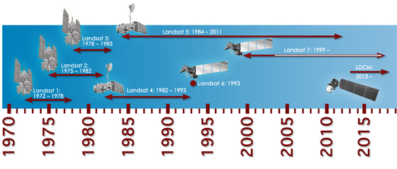
Tentatively excited: the Landsat mission will continue (I think). Its new name will be LDCM: Landsat Data Continuity Mission. Tentative launch date in 2013. More information here. The President's recent budget seemed to inlude continued funding for Earth Observation. The news post I read says: Among the other highlights in the White House summary, spending on Earth observation satellites would be maintained at nearly $1.8 billion next year.

That was fast! Supreme Court rules on GPS & privacy

From the NYTimes today. The Supreme Court on Monday unanimously ruled that the police violated the Constitution when they placed a Global Positioning System tracking device on a suspect’s car and monitored its movements for 28 days.

But the justices divided 5-to-4 on the rationale for the decision, with the majority saying that the problem was the placement of the device on private property. That ruling avoided many difficult questions, including how to treat information gathered from devices installed by the manufacturer and how to treat information held by third parties like cellphone companies.

Walter Dellinger, a lawyer for the defendant in the case and a former acting United States solicitor general, said the decision “is a signal event in Fourth Amendment history.” “Law enforcement is now on notice,” he said, “that almost any use of G.P.S. electronic surveillance of a citizen’s movement will be legally questionable unless a warrant is obtained in advance.”

Previous wrap-up post on the case.

TanDEM-X and TerraSAR-X cover the globe

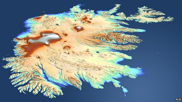
TanDEM's view of Iceland: The country was beyond the sight of the shuttle topography mission in 2000We talked about TanDEM before, after launch. The German satellite radar twins - TanDEM-X and TerraSAR-X - are a year through their quest to make the most precise, seamless map of varying height on Earth.

They've now acquired data across the entire globe at least once. However, some tricky sampling areas, such as tall mountains and thick forests, will require several passes and so we don't expect to see a fully finished product before 2014.

As compared with the Shuttle product at best spatial resolution of 30m by 30m, and a vertical resolution that varies from 16m to 10m, the intention of the TanDEM mission is to go down to a spatial resolution of 12m by 12m and a vertical resolution of 2m. Airbone lidars can achieve much better precision, but these maps are necessarily regional in extent - they will cover only relatively small areas. The purpose of TanDEM is to build a world DEM that is single-source and has "no joins".

Report from the BBC here.

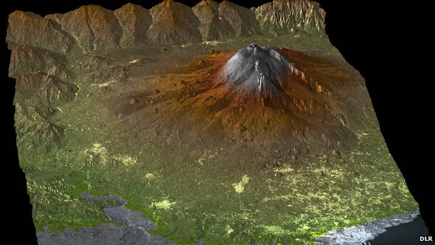
The TanDEM Digital Elevation Model of Mount Etna, Sicily, Italy

The new CA district map challenged in court: maps matter

From KQED, reported this morning. The California Supreme Court today is hearing oral arguments in the case of Vandermost v. Bowen, a rather complicated case related to the redistricting lines that the California Citizens Redistricting Commission drew last year, and which the state Republican Party is none too happy about.

Because the supporters of this referendum (and a lawsuit challenging the maps as well) contend that the law now says the disputed state senate maps drawn by the independent commission cannot be used in 2012 if they're being challenged with a ballot referendum. They say the state Supreme Court would have to step in and draw their own maps.

The defendants in the case are the CA Secretary of State through the attorney general's office. Their case is that the court does not have to step in and draw new temporary maps for the state senate.

This is really a fight over who draws political districts in California: the independent citizens commission, or temporary districts drawn by the California Supreme Court, or possibly even use the old districts, which have existed for the last 10 years.

cesaria evora: 1941-2011

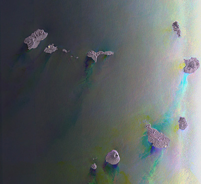
cape verde islands from ENVISATSinger Cesaria Evora, dubbed the "Barefoot Diva" for often performing without shoes, has died in her native Cape Verde at the age of 70.

I was able to see her on two separate occasions at the Zellerbach here on the Berkeley campus. She was truly amazing: commanding our undivided attention as she worked the stage with a large tight band and horn section, and the legendary bare feet and cigarettes.

This Envisat image captures her home, the Republic of Cape Verde, a group of volcanic islands located in the North Atlantic Ocean some 600 km off Africa’s west coast.
 
The archipelago comprises 10 islands and several islets and has a total land area of about 4000 sq km. Islands visible from top left to right are Santo Antão, São Vicente, Santa Luzia, São Nicolau, Sal, Boa Vista, Maio, Santiago, Fogo and Brava.

Wetland restoration reduces sea level rise impacts over next 100 years in the SF Bay

sun setting on bay marshA new study led by Diana Stralberg at PRBO Conservation Science and including work done by our own Lisa Schile, projects a bleak future for San Francisco Bay’s tidal marshes under high-end sea-level rise scenarios that are increasingly likely. PRBO and colleagues found that in the worst case scenario 93% of San Francisco Bay's tidal marsh could be lost in the next 50-100 years (with 5.4 feet or 1.65 meters of sea-level rise, low sediment availability and no significant restoration). Not all marshes will be lost and restoration currently underway can keep more marshes intact as sea levels rise.

"Tidal marshes are incredibly resilient to changes in sea level, depending on how fast seas rise and how much sediment is available.  Unfortunately, marshes cannot keep up with the high-end sea-level rise predictions on their own.  They will need our help.” said Diana Stralberg, the study lead author of PRBO and the University of Alberta.

Our study was published this week in the high-impact journal PLoS ONE. To view maps of where the marshes will be under various scenarios over the next 100 years, visit www.prbo.org/sfbayslr. News coverage from SF Chronicle here. CNR coverage here.

A wrap-up of the news surrounding Supreme Court's foray into GPS + privacy

United States vs. Jones raises questions about the limits of police searches, personal privacy and the use of new technology in law enforcement. At issue is whether police need warrants to attach GPS tracking devices to a cars to monitor suspects' movements for indefinite periods of time.

Stay tuned for more analysis. From NPR, some indication that the Supreme Court was not happy with un-warranted GPS tracking. The justices were told police could slap GPS devices on their cars and track their movements, without asking a judge for advance approval.

Also an interesting take from Wired: A number of Supreme Court justices invoked the specter of Big Brother while hearing arguments Tuesday over whether the police may secretly attach GPS devices on Americans’ cars without getting a probable-cause warrant.

While many justices said the concept was unsettling, the high court gave no clear indication on how it will rule in what is arguably one of the biggest Fourth Amendment cases in the computer age. The Obama administration maintains that Americans have no privacy rights when it comes to their movements in public.

Another informative opinion piece from the Washington Post.

Google acquires facial recognition technology company

Missed this earlier, but found it in prep for my privacy and GIS lecture. The article is excerpted here:

Google has acquired a seven-year-old company that develops facial-recognition technology for images and video, though the Web-search giant didn’t say what it plans to do with it.

Regarding face recognition, the spokesman said, “We’ve said that we won’t add face recognition to our apps or product features unless we have strong privacy protections in place, and that’s still the case.”

Google has said it built facial recognition technology for smartphones into a product known as Google Goggles, but withheld it. “As far as I know, it’s the only technology that Google built and after looking at it, we decided to stop,” said Google Chairman Eric Schmidt last month at a conference. “People could use this stuff in a very, very bad way as well as in a good way.”

Google Goggles is pretty sweet, by the way.

Google Maps to charge for heavy usage

Trick or Treat! Looks like users of Google Map links for their websites will be charged for heavy usage of the service. This from the BBC:

From 1 January 2012, Google will charge for the Google Maps API service when more than the limit of 25,000 map "hits" are made in a day. Websites, especially travel firms, use Google Maps to link customers to a view of the destinations they inquire about.

Cal-Adapt featured on SmartPlanet

Smartplanet recently produced a video featuring Cal-Adapt.  See it here!

At UC Berkeley's Geospatial Innovation Facility software developers are building a Web-based mapping tool to help scientists prepare for the changing climate conditions in California. The team has culled data from various climate research organizations to get projection data of what different climates might look like over a 150-year period. SmartPlanet visits the lab to see a demo of how the tool works.

Cal-adapt in the news: sea level rise needs to be considered in planning

The Bay Conservation and Development Commission (BCDC) recently voted on the planning process in the bay area. They approved a first-of-its kind policy that makes sea level rise part of regional planning decisions. The new rules require developers to plan for rising sea levels in their proposals for waterfront property. Business groups and cities cried foul when the policy was first released, saying it would hurt economic development. The KQED News post features our Cal-Adapt site. More here.

India-Pakistan border as seen from space

From NASA re-posted via Bostom.com's The Big Picture photojournalist website comes this fascinating, geographically-pertinent image: "The India-Pakistan border appears as an orange line in this photograph taken by the Expedition 28 crew on the International Space Station on August 21, 2011. The fence between the two countries is floodlit for surveillance purposes. Srinagar (left), Islamabad (bottom center), Lahore (center near the border line) and Delhi (top center) can be seen as brighter spots. (NASA/Handout/Reuters)#"

Animal tracking with "Smart Collars"

There is an interesting arcticle in today's New York Times about the use of a new breed of animal tracking collars that use on board computers to track valuable information about an animal, beyond location alone.  The new "smart collars" can be used to track when an animal is sleeping, when it is feeding, and lots of other metrics.  The additional data being gathered gives biologists more information to work with while trying to understand the animals habits and needs, in order to provide informed wildlife management decisons.

2011 ESRI User Conference

Earlier this month I attended the ESRI User Conference in San Diego which consisted of numerous presentations by ESRI as well exhibits by various vendors.  Maggi asked that I write up a short

 summary.  I've been collecting my thoughts and reviewing notes.  There were three main points I wanted to explore aside from the overall experience and general opportunity to learn and be a part of the event.

Mobile GIS

ESRI has had a client for the iPhone for some time now.  Soon they will have one for the Android platform as well.  They had working phones for attendees to use with the ability to do real-time data updates.  There is an API in beta for any ESRI customer to download.  If you're interested please let me know and I can obtain it.  The client software that actually runs on the Android device itself is also in the beta stage but is not yet available to download.   Mobile clients can connect to your own ArcGIS server or to data served by ArcGIS Online hosted by ESRI.

The mobile application allows for collection of data, measuring distances, as well as real-time editing and is intended for general users who do not have to be GIS experts.  The edits are shared right away with others who may be using a mobile or desktop application.  Of course, in many situations users may be in an area without an active cell/data connection.  It's still in various stages of development, but the plans are to have the mobile device cache the appropriate levels of map tiles, data, etc., and then sync with the server upon reconnecting much the same way other applications function when away from cell coverage.

ArcGIS Server Configuration

Web servers are typically configured to accept connections from web browsers on TCP port 80.  Behind the scenes there can be many other servers feeding information on other ports.  Sometimes the other servers can accept direct connections without the web server in the middle.  For a number of reasons, security primarily, these other servers are often behind a firewall and do not accept direct connections from web browsers but do allow connections from the web server.  ArcGIS Server communicates GIS data on port 8399.  Since we generally have not had a need to serve confidential or sensitive data we have always allowed a direct connection to our servers on port 8399.  Recently one of our clients found that their in-house network did not allow connections to port 8399 and no GIS data was appearing in their maps.  Thanks to the help from Brian and Sarah V. we were able to come up with an implementation to allow the end users to connect without problems.  But, it was unclear if this was consistent with the ongoing functionality of ArcGIS Server.

There are a number of ways to configure the web server to accept a connection for ArcGIS Server on port 80 and then go behind the scenes to port 8399.  We have been experiencing various issues during the configuration process as outlined in ESRI and other documentation.  There is a lot of good information available, but it has been in the form of a number of different help articles andconfiguration instructions.  It has been difficult to locate one set of cogent instructions to get things configured start to finish.


Thankfully, I was able to sit down one-on-one with an ESRI technical staff member at the conference. He was able to walk through the process on a demo computer outlining the various steps and explain the process.  I had gotten so far on my own, but he was able to go further showing me the steps real-time.  I will be taking a closer look at how to implement this configuration – which is generally considered to be the "correct" method in lieu of direct connections to port 8399 – in our environment.

ArcGIS Software Updates

Both ArcGIS Server and Desktop will be updated to version 10.1 with an expected release of spring 2012 and a number of functions are to be deprecated.  Of course, the most visible changes are to the Desktop application. 

ArcGIS Server 

  • improved handling of API functions, query requests, and database optimization
  • Web Application Developer Framework (ADF) deprecated
  • rewritten to be 64-bit, 32-bit version deprecated
  • easier set-up
  • integrated printing function
  • improved Linux support
  • ArcIMS deprecated

ArcGIS Desktop 

  • scale bars with dual units (such as miles and kilometers)
  • use of magnetic north as a north arrow
  • coordinate system filtering – those inapplicable  to the current map extent not presented as choices
  • Maplex included for free at all license levels
  • new toolbox tools
  • accept GPS data in GPX format and convert to a layer
  • areal interpolation – for example census tract to ZIP code
  • filtering by time
  • support for LIDAR files in .las format
  • ArcInfo Workstation deprecated (version 10.0 will continue to function)
  • VBA deprecated for new development

ArcGIS Runtime 

  • a new developer tool to distribute with applications
  • no separate installation
  • does not require ArcGIS to be installed
  • small memory requirement, fast processing
  • Windows and Linux, 32- and 64-bit versions
  • mobile version later on, can be used offline

It's clear that ESRI intends to continue enhancing their online functionality.  Much of their effort is going toward making their desktop application more integrated with online data sharing.  There is, of course, the arcgis.com service which is an appealing alternative for those without their own server.  Mobile options are growing and again the emphasis is on real-time sharing and not just data collection with an upload later on.  Right along with their online service is ArcGIS Server which ties together all the various clients and applications for an integrated approach.   Your GIS data is the important focus – the same from desktop to mobile to server – and how you access it is, at best, secondary.  ESRI has shown that they are willing to move forward and recognize today's environment by discontinuing older products such as Web ADF, ArcInfo Workstation, ArcIMS, and so on after having supported them beyond their prime levels of functionality.  Overall the conference was a very positive experience, and I'm quite pleased to have had the opportunity to participate.