COVID-19 map resources

Hello all from the new shelter-in-place normal. We are all figuring this new way of working and living out, so in the meantime, stay calm, be compassionate, be positive and productive. At least that is what I am telling myself daily! Thanks to the wonderful former Kellylabber John Connors (who put together a great list), here is a quick round-up of some of the best map resources for COVID-19 out there.

NYTimes: Good map viz, lots of map resources

StoryMap from ESRI: Good visuals, good presentation, detail for China

ESRI: Solutions for local government, Esri toolkits

CDC: simple map from CDC

Stanford: Data visualization, timeline, literature, updated travel bans, and some resources

Washington Post: spread simulation model, showing how social isolation works

WHO: dynamic dashboard (built in Esri tools), up-to-date country totals

Stay safe and healthy out there everyone.

Tracking a Discipline's Evolution

In lab group meetings we have been discussing the evolution and future of Spatial Data Science as a discipline.

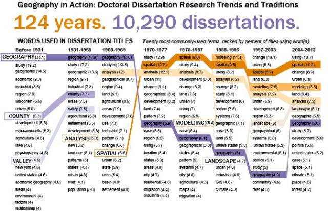
Therefore when I recently stummbled upon a article about a reserarch project looking at the evolution of Geography based on a database of Doctoral Dissertation Titles, I couldn't help but be excited, and intrigued by the connection.

This reasearch from Kent University Professors David Kaplan and Jennifer Mapes is also reminiscent of Kelly Lab's own Shufei Lei's  recent work analyzing and mapping textual data in the context of ecological systems and adapative managment!

Just like spatial data science, Geography as a discipline has struggled with defining its' complex identity, its principles and concepts spanning and borrowing from several established discipinces. 

From the article:

"Geography is a relatively young discipline in terms of university academics, and for much of its history, geographers have struggled to define what exactly the discipline includes, said Keith Woodward, an assistant professor of geography at the University of Wisconsin at Madison.

So for a historical perspective, this type of database would be helpful looking at a timeline of how geographers defined their field, Woodward said."

The database is a compliation of 10,290 dissertations ranging back to the late 1800's with the goal of understanding the trends, concentrations, and expansion of Geography as a discipline over time. 

Although currently unpublished (look out for an article in Geographical Review early 2015) there are a few preliminary findings and possibilites that sound immensly interesting:

"The study maps which universities have high percentages of dissertations focused on domestic or foreign regions, and also shifts in which regions of the world were popular topics for dissertations."

"A database of dissertations could provide a glimpse into what academics are interested in and how their focuses shifts as de-colonization and globalization occurs, Woodward said."

"Much of the focus so far has been on the words within the dissertation titles and how they’re used. Geographers today like to explain the field as a study of space and place, Mapes said. But those words didn’t become popular in dissertations until the 1960s."

Read the full article here and look out for an article in Geographical Review early 2015.
Extremely rare plant discovered in Doyle Drive construction site

Franciscan Manzanita.jpeg

© California Academy of Sciences

The incredibly rare Franciscan Manzanita

A pair of the state's foremost experts in manzanita plants have weighed in that the bush recently uncovered during the Doyle Drive project is a living specimen of the Franciscan Manzanita -- a discovery akin to stumbling across a Dodo or Passenger Pigeon. The plant was last seen in the wild in 1947, when legendary local botanist James Roof ran in front of a platoon of bulldozers to grab a few samples of the bushes just before they were ripped from the ground as the former Laurel Hill Cemetery was converted into homes and buildings.

"It's a very big story," said a laughing Mike Vasey, a lecturer at San Francsico State called in by Presidio officials to examine the plant. Both Vasey and Professor Tom Parker believe the bush to be the genuine article. So they're excited. But two factors are mitigating their joy. First, they'll have to wait a month or two until the plant buds to do a chromosome count and determine it really is the Franciscan Manzanita. And, second, it's smackdab in the middle of where the highway is supposed to go.

"It's hard to say exactly what's going to happen," said Vasey. "My impression is that there's a good chance the individual may be relocated -- hopefully successfully -- and many cuttings will be taken so the genotype can be preserved."

Botanists are fortunate to have several different "bloodlines" of the Franciscan Manzanita -- the cuttings Roof ran in front of the bulldozers to obtain were successfully planted in the East Bay Regional Parks Botanical Garden, where their ancestors thrive still.

Vasey believes the plant in question -- the location of which is being kept guarded for obvious reasons -- may be 40 to 70 years old. It grew on a small outcropping of serpentine rock bordered by the concrete of the highway and the dormant seed may have been stimulated by highway work decades ago. During the current work, plants surrounding the manzanita were cleared, and the bush caught the eye of an ecologist. He called in officials from the Presidio, who, in turn, called in Vasey and Parker.

The Franciscan Manzanita is the close cousin -- and possible genetic precursor -- to the Raven's Manzanita. That extremely rare plant is down to its last genetic individual; the "mother plant" is believed to be more than a century old and sits in an undisclosed location in the Presidio some miles from the newly rediscovered Franciscan Manzanita

  (reposted from SF Weekly blog)