New NAIP imagery available for CA!
/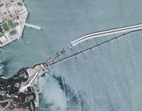 New Bay Bridge construction as seen in the 2009 NAIP imagery
Two great new resources from the National Agriculture Imagery Program (NAIP) are now available for the State of California, and can be download via Cal-Atlas:
2009 Natural Color Imagery: Divided into counties, natural color imagery is now available in MrSid Format. These images were acquired in the summer of 2009.
2005 Color Infrared Imagery: Divided into quarter-quads, color infrared image tiles from the 2005 dataset are now available for the entire state in jpeg2000 format.
Michael Byrne, California’s Geographic Information Officer, estimates that the color infrared imagery from the 2009 dataset will be available in 6-7 months.