Back when maps were big and physical: giant 1924 relief map of CA found in SF
/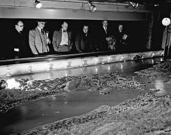 The giant "Paradise in Panorama" relief map of California, made in 1924, was displayed at the Ferry Building. Credit: Barney Peterson / The Chronicle 1963San Francisco's oldest and best-known white elephant - the huge three-dimensional relief map of California that once graced the Ferry Building - has turned up at an undisclosed location on the city's waterfront.
The map was one of the wonders of the West when it was unveiled in 1924. See article from SFGate.
It was as long as two football fields and showed California in all its splendor, from Oregon to Mexico, with snow-capped mountains, national parks, redwood forests, a glorious coastline, orchards and miniature cities basking in the sun. It was made of plaster, wire, paint, and bits of rock and sand. In the summer of 1924, Scientific American magazine said it was the largest map in the world.![]()