Food Environmental Atlas for the US
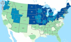
/ Example from the USDA food atlas: pounds per capita of solid fats eatenFood insecurity, diet choice, access to healthy foods: these vary greatly across communities in the US. In order to visualize these patterns and stimulate research and discussion, the USDA has published an online food atlas. The USDA Food Atlas currently includes 90 indicators of the food environment such as: store/restaurant proximity, food prices, food and nutrition assistance programs, and community characteristics—interact to influence food choices and diet quality. It is fairly course, but very illustrative of spatial pattern of food insecurity, diet, access to restaurants and fast food, and many other factors. With this interactive atlas, you can:
-
Create maps showing the variation in a single indicator across the U.S.; for example, variation in the prevalence of obesity or access to grocery stores across U.S. counties. Check out this scary example above: pounds per capita of solid fats eaten (light green - low; dark blue high, up to 24 pounds);
-
View all of the county-level indicators for a selected county;
-
Use the advanced query tool to identify counties sharing the same degree of multiple indicators; for example, counties with both high poverty and high obesity rates;
- Download data.