New SNAMP spatial newsletter on lidar posted
/This is an exerpt from our recent SNAMP newsletter on our lidar work, written by me, Sam, and Qinghua.
We are using Lidar data to map forests before and after vegetation treatments and measuring forest habitat characteristics across our treatment and control sites. These data will give us detailed information about how forest habitat was affected by fuel management treatments.
 Visualizing the forest
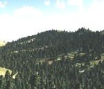
The image at left is not a photograph: it is a computer generated image of our SNAMP study area, using only Lidar data. These kinds of visualizations are commonly used in the forestry field for stand and landscape management, and to predict environments into the future. But visualization software packages usually only focus on one stand at a time. Our method allows us to visualize the whole firescape. This is useful for understanding the complexity in forest structure across the landscape, how the forest recovers from treatments, and how animals with large home ranges might use the forest. The UC Merced team created this cutting-edge product.
Finding the trees in the forest
In order to see the trees in the forest, the UC Merced spatial team researchers developed a method to segment individual trees from the Lidar point cloud. The method identifies and classifies trees individually and sequentially from the tallest tree to the shortest tree. We tested this method on our SNAMP Lidar data. These forests are complex mixed coniferous forests on rugged terrain, and yet our method is very accurate at defining individual tree shapes. We are applying the method in both of the SNAMP study areas.
 Mapping downed Logs with lidar data
The UC Berkeley spatial team researchers used some new techniques that help distinguish individual features, and mapped the logs, as well as some of the trees in this stand. In the figure at left: red colors are logs, green colors are trees.
More information on these and other projects can be found on the SNAMP website.