Satellite images of Nigerian towns attacked by Boko Haram
/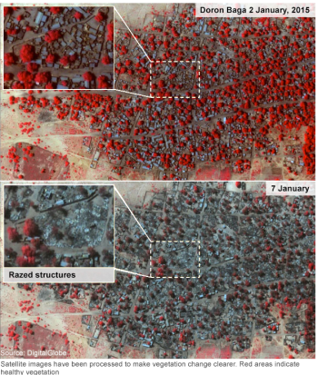 Amnesty's before and after satellite images were taken on 2 January and 7 January. Healthy vegetation is shown in red on the graphics.This is related to the paper that Alice and I just published on the use of remote sensing for crime. In that paper, we make it clear that estimates of crime from remote sensing are very difficult to validate; however, these important efforts continue to expand. Case in point from the BBC: Satellite images of Nigerian towns attacked by Boko Haram show widespread destruction and suggest a high death toll, Amnesty International says.
The images show some 3,700 structures damaged or destroyed in Baga and Doron Baga this month, Amnesty said. This is in stark contrast with goverment estimates of destruction.
The BBC's Will Ross says that while the images show the destructive nature of Boko Haram, they do not help establish just how many people were killed.
Last week, Musa Alhaji Bukar, a senior government official in the area, said that fleeing residents told him that Baga, which had a population of about 10,000, was now "virtually non-existent".