Bing Maps adds new enhanced features

Bing Maps, Microsoft's online mapping application, has just launched a big update in Bing Maps Beta with lots of cool new features.  As you will see, the new maps site requires the installation of "silverlight" which you will be prompted to install, but it can be used in most ie, firefox, or safari browsers. 

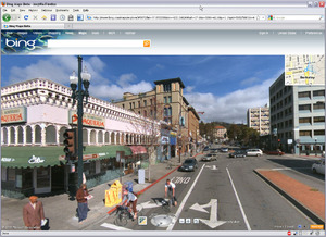
Though there are many new features, be sure to check out the "Streetside" viewer, Microsoft's answer to Google's Street view.  Streetside takes a similar aproach in displaying photos along streets, but also takes advantage of the building surfaces for 3D viewing.


DataSF.org - a new San Francisco data resource

The City of San Francisco has recently developed a new website (http://datasf.org) to help disseminate data related to the city’s elections, environment, geography, health, housing, public safety, public works, and transportation.  Many of which are available in GIS format!

From the site:

DataSF is a clearinghouse of datasets available from the City & County of San Francisco. While there is plenty of room for improvement, our goal in releasing this site is:
(1) improve access to data
(2) help our community create innovative apps
(3) understand what datasets you'd like to see
(4) get feedback on the quality of our datasets.

In addition to the wealth of data sources, there is also a section showing off some of the applications that outside developers have created with the data.

New NAIP imagery available for CA!

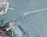
New Bay Bridge construction as seen in the 2009 NAIP imagery

Two great new resources from the National Agriculture Imagery Program (NAIP) are now available for the State of California, and can be download via Cal-Atlas:

2009 Natural Color Imagery: Divided into counties, natural color imagery is now available in MrSid Format.  These images were acquired in the summer of 2009.

2005 Color Infrared Imagery: Divided into quarter-quads, color infrared image tiles from the 2005 dataset are now available for the entire state in jpeg2000 format. 

Michael Byrne, California’s Geographic Information Officer, estimates that the color infrared imagery from the 2009 dataset will be available in 6-7 months.

TauDEM software: for your hydro modeling needs

This was recommended to me recently by Orien; he is using it to create topographic indices to use as ancillary data in an object-based classification of palustrine wetlands in the foothills of the Sierra Nevada. These wetland sites are terrifically important for rails, and mapping them efficiently is a challenge.  Topographic information is proving useful in the classification, and Orien used this software rather than the ArcGIS hydro modeler suite.

From David Tarboton at Utah State: Terrain Analysis Using Digital Elevation Models (TauDEM) is a set of tools for the analysis of terrain using digital elevation models. TauDEM currently provides numerous capabilities that expand on the ESRI suite including (more listed on website):

  • Computation of flow directions and slopes;
  • Contributing area using single and multiple flow direction methods;
  • Multiple methods for the delineation of channel networks that include curvature;
  • Delineation of watersheds and subwatersheds draining to each stream segment; and
  • Specialized functions for terrain analysis, including wetness indices, accumulation measures, and downslope and upslope functions.

Some favorite ecology-related mashups

From Ken-ichi Ueda and friends: iNaturalist.org.

  • Where you can record what you see in nature, meet other nature lovers, and learn about the natural world. Colorful, well-designed and useful, this site is a must for all you explorers of the natural world, or those of you who just ponder the wildlife in your backyard.

From GreenInfo Network and CalLands:

  • The new California Protected Areas Database (CPAD 1.3) has just been released in geodatabase and shape file formats, and is available through google maps overlay here.

From UC Davis' Road Ecology Center and the Information Center for the Environment: California Roadkill Observation System.

  • You can report roadkills you observe anywhere in the state, helping all of us to understand the causes of roadkill and how we can reduce the conflict between animals and vehicles. Roadkill is a major cause of mortality for many animals in California, but designing appropriate management responses takes political support, money, and knowledge of where and how to act. Roadkill data are an important part of that equation and we invite you, our expert colleagues, to join us in collecting these data on a public site.

From my lab: the OakMapper.

  • OakMapper is designed to let users explore the locations of confirmed P. ramorum sites, and contribute to our database by reporting trees that might have the disease. And it is now mobile! Speaking of mobile:

From Imperial College London: EpiCollect.

  • A mobile phone application will help professional and "citizen" scientists collect and analyse data from "in the field", anywhere in the world. The EpiCollect software collates data from certain mobiles - on topics such as disease spread or the occurrence of rare species - in a web-based database. Uses Android. The BBC article.


Bing map layers now available in ArcGIS applications

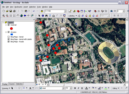
ESRI and Bing Maps (formerly Microsoft Virtual Earth) have recently developed a seamlessly integrated solution to view Bing’s aerial, road, or hybrid data as a base map in ArcGIS applications.  These layers are the same that can be viewed via Bing Maps web interface offering a huge variety of imagery throughout the world including very high resolution sources.

The layers are easily integrated into ArcMap by adding the .lyr files from ESRI’s website to any project.  These small .lyr files may be saved on your hard drive and accessed just like any other layers that you have stored locally.   In order to use these layers, however, you will need to have the latest version of ArcMap (9.3.1) installed, and a new license must be installed as described in the link.  For those of you connecting through UC Berkeley’s license server, you will be happy to know that this license update has already been made.

Indigenous mapping network at UC Berkeley

Our friends from DataBasin are on campus on Monday. Kai Henifin is a Cultural Ecologist/GIS Analyst with the non-profit organization Conservation Biology Institute, the developers of DataBasin. Kai will be speaking about "Incorporating Indigenous Knowledge to Improve Conservation through Data Sharing" as part of the Berkeley Indigenous Mapping Network. For more info on the event.

We have some interesting cross-overs with CBI and DataBasin: we added our SOD data to DataBasin recently (see image at left); and CBI have a nice modeling project looking at fisher in the southern Sierra that Reg and Rick are using in their SNAMP work.

Mapping virtual trees and buildings

From a series of news releases (all text, no pics, alas): UK aerial survey specialist Bluesky has launched a brand new digital map layer accurately modelling the location and extent of trees and their proximity to buildings. Designed as a tool to aid insurance assessors, property developers and Local Authority Planners, ProximiTREE details the exact spatial location and height of individual trees together with the circumference of its canopy. From this information a determination can be made of the root extent and the potential impact on either existing or proposed properties.

They plug this product for its use in avoiding building subsidence, but in fire-prone Cali, we could use it to look at defensible space and risk.

They also provide a range of good downloads, including sample data and software for your enjoyment.

Democratizing Data

The Federal CIO Coucil has just launched Data.gov, a site that brings all federal data into one searchable place. You can directly download xml, csv, kml/kmz, and shp files and find links to tools for finding other data.

Here are some more details from the White House press release:

"Created as part of the President's commitment to open government and democratizing information, Data.gov will open up the workings of government by making economic, healthcare, environmental, and other government information available on a single website, allowing the public to access raw data and transform it in innovative ways.

Such data are currently fragmented across multiple sites and formats—making them hard to use and even harder to access in the first place. Data.gov will change this, by creating a one-stop shop for free access to data generated across all federal agencies. The Data.gov catalog will allow the American people to find, use, and repackage data held and generated by the government, which we hope will result in citizen feedback and new ideas.

Data.gov will also help government agencies—so that taxpayer dollars get spent more wisely and efficiently. Through live data feeds, agencies will have the ability to easily access data both internally and externally from other agencies, which will allow them to maintain higher levels of performance. In the months and years ahead, our goal is to continuously improve and update Data.gov with a wide variety of available datasets and easy-to-use tools based on public feedback and as we modernize legacy systems over time.

Democratizing government data will help change how government operates—and give citizens the ability to participate in making government services more effective, accessible, and transparent."
 

Ghost Maps

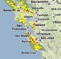
There are over 35 million geotagged, time-stamped photos on flickr now. That's enough to start doing some pretty interesting analyses, including this one from Crandall, et al., at Cornell (presented at the WWW 2009 conference, "Mapping the World's Photos" [PDF]).  Not only is it possible to map hot spots of world tourism, but by incorporating the time stamps to map the routes people are taking, you can make out individual streets. As suggested by the Information Aesthetics blog, you could even design popular walking tours.

Once GPS-enabled cameras represent a larger share of the market, flickr may provide data for all sorts of important analyses: tracking SOD, the migration of an endangered song bird, or estimating the "desolation" of a place: the world heat map that the Cornell group presents looks shockingly like the lights at night. The machine... it's ALIVE!!!

helpful new features from ESRI

here are some gems I learned about at CalGIS:

1. Go to ArcGIS Online Resources to quickly, easily, and freely add in terrific basemap data and high res imagery to any .mxd. If you are logged in you will have access to a lot more options.

2. Arc 9.3.1 (to be released any day now) will include a "layer packages" feature. So, if you want to send someone your file exactly as you are looking at it, you can right click on the layer and select "save as layer package", and it will zip the .shp + .lyr into a .lpk to share more easily. Also, there will be free access to Microsoft Virtual Earth within your Arc desktop.

LiDAR and 3″-4″ ortho files of Contra Costa County available!

I went to the Contra Costa Countywide GIS meeting yesterday and found out about these countywide files that were recently posted to the Casil FTP site in the coco-county folder. Infrared imagery is expected to be posted by January 2009. The LiDAR was flown for flood control analysis, but it is publicly available for any other research. The county GIS deptartment asks that you contact them to share how you work with the data. Also, I came across this LiDAR resources site with links to other data and helpful info.

FANTASTIC Bay Area spatial data

  If you love detailed spatial data and/or the bay area, I HIGHLY recommend downloading and exploring the readily available Upland Goals Project Data . Ryan Branciforte introduced  it to us last week during his enlightening geolunch presentation about his work with the Bay Area Open Space Council. There is a wealth of data for all interests, including vegetation, animals, environmental features, weather patterns, fire risk, and even camp sites if you want to plan a trip to go look at all the data on the ground.

Access private data at the UC Berkeley Census Research Data Center

Kevin and I went to a talk this week and found out about a very under-utilized resource on campus, the Research Data Center (RDC). It is one of only 9 RDCs in the U.S., and it is the only location where you can access non-public demographic, health, and economic data that contain detailed information on geographic location and/or other characteristics about firms or households. For an overview of all the confidential data you can seek access to,  look over the CRDC's data page, and specific details about each can be found at the Center for Economic Studies Data Page. The application process is described as "rigorous and lengthy", but the people at the center seem very friendly and eager to help more researchers use their data. For a list of other data resources on campus, check out the UC Data resources page.

GPS on a Mac

I have been doing some GIS noodling on my Mac recently, since it is an Air and very nice. So, what can you do without parallels on a Mac? Lots. The new QGIS with Grass plugins is great, but if you want to just get your hiking points in and overlaid on an image, you can use GPSbabel. Also free (with suggested donations though, and it is a good thing). You can download your waypoints, tracks and routes from your Garmin (I used a GPSMap 60CSx) with GPSbabel (use the GPX format) and use the GPS plugin in QGIS to easily map them. But, going the other way? that is more difficult. I used GPSbabel with csv format (x, y, id) and uploaded an important route to my Garmin. I was feeling all adventurous until a colleague sent me this link: ben sinclair's site: how to use a garmin with your mac which sorts it all out for you.

California Protected Areas Database is released

From Ryan Branciforte: the new data depicting CA protected lands (exclusive of easements) is ready. The California Protected Areas Database (CPAD) is a GIS inventory of all protected open space lands in the State of California. The database contains lands held in fee ownership by public agencies and non-profits - it does not contain data on private conservation and other similar public agency easements. Version 1.0 of CPAD was released on May 1, 2008.