Job Opening: Informatics and Geographic Information Systems Program Coordinator

The University of California Agriculture and Natural Resources, a statewide program with local development and delivery, is seeking an Academic Coordinator to provide IGIS analysis, coordination and support to the Informatics and Geographic Information Systems (IGIS) team to the meet the IGIS mission.  IGIS is established to assist and advance research and extension activities by coordinating the development of Informatics and GIS tools and applications and make them available through an online web‐accessible portal.

The IGIS program coordinator will coordinate with the IGIS leadership team to advance ANR’s Strategic Vision of close partnerships between researchers, Cooperative Extension specialists and advisors, and the people of California by providing geospatial and informatics tools, data, training, consultation, and map products to the Division of Agriculture and Natural Resources. The program coordinator will support IGIS interests and projects across ANR, encouraging collaboration across ANR operational units, and develop contacts within the University’s geospatial community.

Location headquarters: Davis or Berkeley, Calif.

Position description: http://ucanr.edu/Work_in_Progress/Jobs_990/?jobnum=556

IGIS website: http://igis.ucanr.edu/

ANR website:  http://ucanr.edu/jobs/

UCOP web site:  http://jobs.universityofcalifornia.edu/

California Water Blog talks about our future

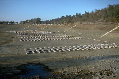
Boat slips in Folsom Lake in a drought (1976). The reservoir was at 18 percent of capacity on Tuesday (Jan. 7, 2013). Source: California Department of Water ResourcesAs a follow-up to this disasterous news about California's water situation, here is a very thought provoking blog about California's water future. They list their 10 predictions for our changed future, including:

  • Parts of the Sacramento-San Joaquin Delta will permanently flood.
  • The Tulare Basin and San Joaquin River regions will have less irrigated agriculture.
  • Urban areas will use less water per capita, reuse more wastewater and capture more stormwater.

Check out the California Water Blog - Resistance is futile: Inevitable changes to water management in California.

http://californiawaterblog.com/2014/01/07/resistance-is-futile-inevitable-changes-to-water-management-in-california/.

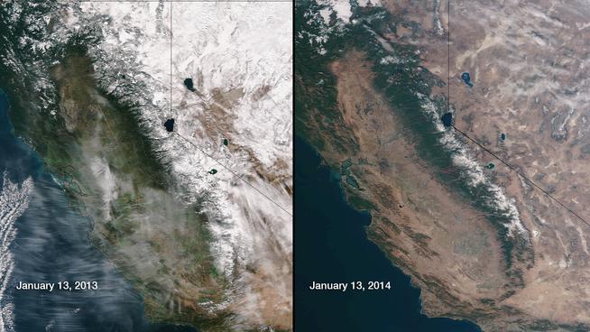
NASA Shows Just How Bad The California Drought Is and Jerry Brown declares a state of emergency in California

One image from NASA shows just how severe the California drought is click here for more about this image

Governor Jerry Brown officially declared a drought emergency in California, asking residents to voluntarily reduce their water use by 20 percent and committing to bolster the state's dwindling water supplies with better management and federal assistance. Read more here

Spring 2014 GIF workshop schedule

UC Berkeley's Geospatial Innovation Facility (GIF) is offering 10 training workshops this semester that use a hands-on approach to help you get started using spatial analysis to enhance your research.  

GIF workshops are available at a subsidized rate of $84 each for all UC students, faculty, and staff, and $224 each for all non-UC affiliates.  View the GIF website to learn more about the following workshops and to register.

  • 1/31, 12-4 pm. Intro to Geographic Information Systems (GIS): Environmental Science Focus
  • 2/7,  12-4 pm. Intro to Geographic Information Systems (GIS): Social Science Focus
  • 2/21, 12-4 pm. Intro to Global Positioning Systems (GPS): Working with Garmin receivers=
  • 3/7, 12-4 pm. Intro to Remote Sensing: Understanding digital imagery
  • 3/14, 12-4 pm. Intro to Remote Sensing:Pixel-based analysis
  • 3/21, 12-4 pm. Intro to Remote Sensing: Land cover change analysis
  • 4/11, 12-4 pm. Intro to Remote Sensing: Object-based image analysis (OBIA)
  • 4/18, 12-4 pm. Intro to Open Source GIS: Working with Quantum GIS (QGIS)
  • 4/25, 12-4 pm. Creating your own web maps
  • 5/2, 12-4 pm. Intro to species distribution modeling

Summary of IGIS Survey (from 2013)

In 2013, the IGIS team developed the Survey of Informatics and GIS Needs, Knowledge and Data Availability that ran from January 14 – March 15. It was a short and comprehensive survey that helped us to evaluate the level of Informatics and GIS expertise and use of geospatial tools and data in ANR. The results are assisting the IGIS team to design and provide tools, analysis, and training to ANR personnel.

Our conclusion from the survey is that IGIS can play a large and new role in training, analytical support, and databasing across ANR. We can fill a need with IGIS: 79% of respondents are not getting assistance from ANR, yet across the board, ANR personnel need Informatics and GIS assistance - over 70% of respondents need GIS work or analytical support on their projects. While 81% have not taken ANR provided GIS training, 80% would take ANR provided GIS training. Also, despite the ability for ANR personnel to use the UC Davis site license, nearly half of respondents do not think they have access to GIS software.

We received 112 unique responses from across ANR. Respondants came from across ANR, and included:

  • Academic Administrators    2
  • Academic Coordinators   2
  • Administrators    4
  • AES Faculty    6
  • Lab Staff    3
  • Office Staff    5
  • Other    10
  • REC Directors    2
  • UC Researchers    3
  • UCCE Advisors    32
  • UCCE Specialists    15
  • UCCE Statewide Program Staff    2

We are looking at doing another survey in 2014, to continue to understand GIS needs in ANR.

Conference at UCB on Digital Privacy and Surveillance - March 6

Pan-Optics: Perspectives on Digital Privacy and Surveillance

March 6, 10:30 a.m.-4 p.m. 310 Sutardja Dai Hall, Banatao Auditorium

bit.ly/pan-optics2014

Featured Speakers: Rebecca MacKinnon, Senior Research Fellow, New America Foundation; Trevor Paglen, Artist, Social Scientist, and Author

Advances in drone aircraft, networked cameras, and recent disclosures about the NSA’s international and domestic surveillance activities have stimulated public protests, outrage from activists, and new policy discussions among elected leaders. This symposium will highlight emerging perspectives on visual privacy and consider the state of the art from a variety of disciplines and professions, including technology, journalism, filmmaking and the arts.

Though traditionally considered separate domains, visual and digital surveillance practices are being combined as machine vision, facial recognition and other technologies become more sophisticated and interoperable. Institutional surveillance by semi-autonomous drones and remote cameras, citizen video monitoring, and incessant photo-sharing and tagging on social networks enable perpetual documentation. The same tools can be used for both transparency and repression.

This symposium will bring together scholars and practitioners from a range of disciplines to discuss privacy protections, surveillance methods, and modes of resistance in a digital age. The program will feature two keynote addresses and two panel discussions that will explore emerging surveillance technologies and applications across a range of contexts, and then turn to resistant strategies employed by individuals and organizations in response.

Registration required: $20 General Admission,  $10 Faculty or Staff,  $5 Students

Citizen science: key questions explored in a new report

In a recent article published in the Guardian, Michelle Kilfoyle and Hayley Birch discuss the widespread use of citizen science initiatives. They recently produced a report (pdf) for the Science for Environment Policy news service, in which the authors review a number of citizen science case studies, and explore the potential benefits of citizen science for both science and society, especially given the advent of new mobile technologies that enable remote participation. They also ask interesting questions about who really benefits the most from these developments: the amateurs or the professionals?

Key questions addressed and highlighted in this report include:
  1. How could new and developing technologies help citizen science projects feed into environmental policy processes?
  2. Is environmental data produced by citizen scientists as accurate as environmental data produced by professional scientists?
  3. How can citizen science benefit environmental monitoring and policymaking?

Big Data for sustainability: an uneven track record with great potential

An interesting position piece on the appropriate uses of big data for climate resilience. The author, Amy Luers, points out three opportunities and three risks.

She sums up:

"The big data revolution is upon us. How this will contribute to the resilience of human and natural systems remains to be seen. Ultimately, it will depend on what trade-offs we are willing to make. For example, are we willing to compromise some individual privacy for increased community resilience, or the ecological systems on which they depend?—If so, how much, and under what circumstances?"

Read more from this interesting article here.

Dense cities contribute less GHG

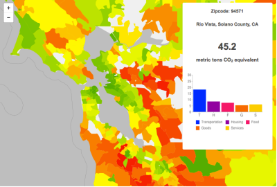
A CoolClimate Map of the SF Bay Area's carbon footprint by zipcode tabulation area shows a pattern typical of large metropolitan areas: a small footprint (green) in the urban core but a large footprint (orange and red) in surrounding suburbs.According to a new study by Dan Kammen and graduate student Christopher Jones at UC Berkeley, population-dense cities contribute less greenhouse-gas emissions per person than other areas of the country, but these cities’ extensive suburbs essentially wipe out the climate benefits.

Dominated by emissions from cars, trucks and other forms of transportation, suburbs account for about 50 percent of all household emissions – largely carbon dioxide – in the United States.

The study uses local census, weather and other data – 37 variables in total – to approximate greenhouse gas emissions resulting from the energy, transportation, food, goods and services consumed by U.S. households, so-called household carbon footprints.

A key finding of the UC Berkeley study is that suburbs account for half of all household greenhouse gas emissions, even though they account for less than half the U.S. population. The average carbon footprint of households living in the center of large, population-dense urban cities is about 50 percent below average, while households in distant suburbs are up to twice the average.

Interactive carbon footprint maps for more than 31,000 U.S. zip codes in all 50 states are available online at http://coolclimate.berkeley.edu/maps.

A link to their paper in Environmental Science & Technology is here: Spatial distribution of U.S. household carbon footprints reveals suburbanization undermines greenhouse gas benefits of urban population density (ES&T, 2014)

From: http://newscenter.berkeley.edu/2014/01/06/suburban-sprawl-cancels-carbon-footprint-savings-of-dense-urban-cores/

Graduate 
Certificate
 in 
GIS approved for UC Berkeley

 Great news! 

The UC Berkeley Graduate 
Certificate 
in
 Geographic 
Information 
Science 
and
 Technology
 (GIST)
 has been approved. This certificate will provide
 an 
academic
 structure 
for 
an 
interdisciplinary 
exchange 
of
 ideas 
around
 geospatial
 information 
and 
analysis. 

 Certificate
 students 
will
 not 
only
 participate 
in
 a 
cutting‐edge 
program 
and
 receive
 explicit
 recognition
 of 
specialization 
in
 GIST
 by 
virtue 
of
 the
 Graduate
 Certificate 
but
 will 
be
 well
 positioned
 to
compete
 for 
the
 most
 desirable 
jobs 
in 
geospatial
 technology,
 both 
in
 academia
 and 
in 
industry.

Requirements include at
 least 
three 
courses, 
or 
a
 total
 of
 90 
hours
 of
 instruction, 
and
 earn 
a
 minimum 
grade
 of
, and participate in a GIST Roundtable (such as the geolunch series from the GIF). More details to be posted in the spring at GIS@Berkeley.edu.

Help to Validate Global Land Cover with GeoWiki and Cropland Capture

Courtesy of the International Institute for Applied Systems Analysis

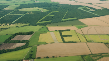
This creative project from GeoWiki seeks to get croudsourced feedback on crop types from participants around the world. They say: 

By 2050 we will need to feed more than 2 billion additional people on the Earth. By playing Cropland Capture, you will help us to improve basic information about where cropland is located on the Earth's surface. Using this information, we will be better equipped at tackling problems of future food security and the effects of climate change on future food supply. Get involved and contribute to a good cause! Help us to identify cropland area!

Oh yeah, and there are prizes!

Each week (starting Nov. 15th) the top three players with the highest score at the end of each week will be added to our weekly winners list. After 25 weeks, three people will be drawn randomly from this list to become our overall winners. Prizes will include an Amazon Kindle, a brand new smartphone and a tablet.

Those crowded skies: Flight maps and delays

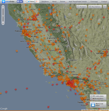
real time map of flights from planefinder.netYou've probably seen the frequently-cited "Misery Map" (D3 behind the scenes) showing how the Thanksgiving storm has blown many a tight travel plan off schedule.

Here is another cool one: real-time map of all the flights in the air. It looks crowded!

How it works.


Happy and safe travels everyone.

FlightAware.com has created the Misery Map, a real-time weather and flight data visualization tool that overlays Nexrad radar imagery on a map of the country, with red-green graphs showing the pain at major airports.
Read more at http://www.flyingmag.com/technique/flight-planning/flightaware-misery-map-tracks-travel-delays#tXwGX8OjSo5QhDUk.99

Happy Thanksgiving everyone! version 2013

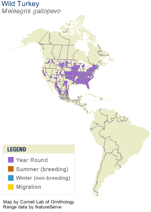
Range map of our friend Meleagris gallopovaThe ancestor all present-day gobblers—Meleagris gallopova - ranged from southeastern Canada to Mexico. 

Our present-day wild turkey has a loud call, with descending gobbles, and a variety of clucking notes. He struts through open woodlands, oaks, edges, and the occasional suburb.

The Wild Turkey’s popularity at the table led to a drastic decline in numbers, but they have recovered and now occur in every state except Alaska.

I think Ben Franklin said it best, in comparing the turkey to the eagle:

For in Truth the Turk'y is in comparison a much more respectable bird, and withal a true original native of America.... He is, (though a little vain and silly, it is true, but not the worse emblem for that,) a Bird of Courage, and would not hesitate to attack a grenadier of the British Guards, who should presume to invade his Farm Yard with a red Coat on.

Happy Thanksgiving Everyone!

Information from A Short History of the Turkey by the Collonial Williamsburg Newsletter, and BirdFellow.com.

GIS Day 2013 Report: Mulford Hall comes alive in a dark and stormy evening

Discovering the World Through GIS

November 20, 2013 -

UC Berkeley, Mulford Hall

GIS Day provides an international forum for users of geographic information systems (GIS) technology to demonstrate real-world applications that are making a difference in our society.

Berkeley's GIS Day 2013 was held at UC Berkeley's Mulford Hall for the eighth year in a row. This year's event was co-hosted by the Geospatial Innovation Facility (GIF) and GIS Education Center (GISEC) with support from the Bay Area Automated Mapping Association (BAAMA) and American Society for Photogrammetry and Remote Sensing NorCal (ASPRS). We had great talks from a number of speakers, including our very own Shufei Lei!

  • Laci Videmsky New California Water Atlas: Building a Digital Public Work: A New California Water Atlas
  • Larry Orman GreenInfo Network Data, Tools and Communication for Public Interest Geospatial
  • Jeanne Jones U.S. Geological Survey Pedestrian Evacuation Analysis for Tsunami Hazards
  • Dennis Klein Boundary Solutions, Inc. Parcel-Level GIS protocol adopted by Mill Valley to guide Sustainable Community Development by posing 3 questions: What’s your Walk, Transit, and Solar
  • Shufei Lei Environmental Science, Policy, and Management, UC Berkeley Measuring learning in adaptive co-management by mapping dialogues using Self-Organizing Map: Sierra Nevada Adaptive Management Project
  • Michelle Koo & Falk Schuetzenmeister Museum of Vertebrate Zoology & Geospatial Innovation Facility, UC Berkeley Place, Space and Time: Rescuing and integrating biological and environmental data in the face of global change
  • Bruce Joffe & Reg Parks GIS Consultants & Santa Rosa Junior College Supporting an Accessible Geodetic Control Network for California

We had over 120 people in Mulford Hall: presenting, listening, learning and networking. Thanks All!

For more information, please see the GIF website. 

The evolution of a Digital Earth

In 1998 Al Gore made his now famous speech entitled The Digital Earth: Understanding our planet in the 21st Century. He described the possibilities and need for the development of a new concept in earth science, communication and society. He envisioned technology that would allow us "to capture, store, process and display an unprecedented amount of information about our planet and a wide variety of environmental and cultural phenomena.” From the vantage point of our hyper-geo-emersed lifestyle today his description of this Digital Earth is prescient yet rather cumbersome: 

"Imagine, for example, a young child going to a Digital Earth exhibit at a local museum. After donning a head-mounted display, she sees Earth as it appears from space. Using a data glove, she zooms in, using higher and higher levels of resolution, to see continents, then regions, countries, cities, and finally individual houses, trees, and other natural and man-made objects. Having found an area of the planet she is interested in exploring, she takes the equivalent of a "magic carpet ride" through a 3-D visualization of the terrain.”

He said: "Although this scenario may seem like science fiction, most of the technologies and capabilities that would be required to build a Digital Earth are either here or under development. Of course, the capabilities of a Digital Earth will continue to evolve over time. What we will be able to do in 2005 will look primitive compared to the Digital Earth of the year 2020. In 1998, the necessary technologies were: Computational Science, Mass Storage, Satellite Imagery, Broadband networks, Interoperability, and Metadata. 

He anticipated change: "Of course, further technological progress is needed to realize the full potential of the Digital Earth, especially in areas such as automatic interpretation of imagery, the fusion of data from multiple sources, and intelligent agents that could find and link information on the Web about a particular spot on the planet. But enough of the pieces are in place right now to warrant proceeding with this exciting initiative.” 
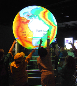
Example from NOAA's Science on a Sphere projectMuch has changed since he gave his talk, obviously. We have numerous examples of Virtual Globes for data exploration - for example, Google Earth, NASA’s WorldWind, ESRI’s ArcGIS Explorer, Bing Maps 3D, TerraExplorer, Marble.  (These virtual examples are made tangible with NOAA's terrific Science on a Sphere project.)

We also have realized a new vision of the Digital Earth that includes much more than immersive viewing of data. Today’s Digital Earth vision(s) include analytics and expertise for solving problems that are often cross-discplinary and large scale. Additionally, we make much more use today than was anticipated in 1998 from sensor networks and the geoweb (e.g. volunteered geographic information and croudsourcing). Examples of this multi-disciplinary Digital Earth concept include Google Earth Engine (and its recent forest loss product), Nasa Earth Exchange, and our own HOLOS.

NSF has adopted this concept for their Earth Cube concept. Last year NSF was looking for transformative concepts and approaches to create integrated data management infrastructures across the Geosciences. They were interested in the multifaceted challenges of modern, data-intensive science and education and envision an environment where low adoption thresholds and new capabilities act together to greatly increase the productivity and capability of researchers and educators working at the frontiers of Earth system science. I am not sure if this will be funded in 2014, but the concept reafirms that the concept of the Digital Earth is widespread and will likely be an important part of academia.
Global forest change from Landsat and Google

The video describing the partnership and the product is available now.

A new high-resolution global map of forest loss and gain has been created with the help of Google Earth. The interactive online tool is publicly available and zooms in to a remarkably high level of local detail - a resolution of 30m. Snapshot of Russia here (green = forest, blue = gain, red = loss):

Russia has much forest activity

Results from time-series analysis of 654,178 Landsat images from 2000–2012 characterize forest extent and change. Between 2000 and 2012, according to this analysis, the Earth lost a combined "forest" the size of Mongolia. http://www.bbc.co.uk/news/science-environment-24934790

Here is the abstract from the accompanying paper in Science:

Quantification of global forest change has been lacking despite the recognized importance of forest ecosystem services. In this study, Earth observation satellite data were used to map global forest loss (2.3 million square kilometers) and gain (0.8 million square kilometers) from 2000 to 2012 at a spatial resolution of 30 meters. The tropics were the only climate domain to exhibit a trend, with forest loss increasing by 2101 square kilometers per year. Brazil’s well-documented reduction in deforestation was offset by increasing forest loss in Indonesia, Malaysia, Paraguay, Bolivia, Zambia, Angola, and elsewhere. Intensive forestry practiced within subtropical forests resulted in the highest rates of forest change globally. Boreal forest loss due largely to fire and forestry was second to that in the tropics in absolute and proportional terms. These results depict a globally consistent and locally relevant record of forest change.

Hansen, M.C.; Potapov, P.V.; Moore, R.; Hancher, M.; Turubanova, S.A.; Tyukavina, A.; Thau, D.; Stehman, S.V.; Goetz, S.J.; Loveland, T.R.; Kommareddy, A.; Egorov, A.; Chini, L.; Justice, C.O.; Townshend, J.R.G. High-Resolution Global Maps of 21st-Century Forest Cover Change. Science 2013, 342, 850-853

NASA shares satellite and climate data on Amazon’s cloud


NASA has announced a partnership with Amazon Web Services that the agency hopes will spark wider collaboration on climate research. In an effort that is in some ways parallel to Google's Earth Engine, NASA has uploaded terabytes of data to Amazon's public cloud and made it available to the anyone. 

Three data sets are already up at Amazon. The first is climate change forecast data for the continental United States from NASA Earth Exchange (NEX) climate simulations, scaled down to make them usable outside of a supercomputing environment. The other two are satellite data sets—one from from the US Geological Survey's Landsat, and the other a collection of Moderate Resolution Imaging Spectroradiometer (MODIS) data from NASA's Terra and Aqua Earth remote sensing satellites.

More Here

Just how much do we need the rain?

Reservoir Drought Monitor Categories - Sep 30, 2013

From DWR's California Data Exchange Center - Reservoirs.

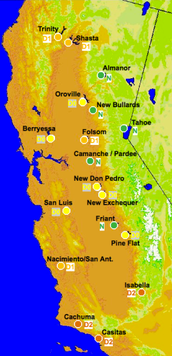
Callfornia is a pretty dry state as we roll into the winter season, but the bad news is spread over the state in different ways.  As of September 30, 17 of the 18 main reservoirs in the state are below 50% of normal storage percentiles. That is not quite as bad as it sounds, 5 of these reservoirs - Friant, Tahoe, New Bullards Bar, Almador and our very own Camanche/Pardee (which catches the lovely water of the Mokolumne River and satiates us EBMUDders) - are classified as "Normal" status. Three reservoirs - Cachima, Casitas and Isabella - are classified as "Drought Severe" status. Those three are in the southern portion of the state.

For more on our water supplies, check out http://cdec.water.ca.gov.

In case you want to know more about the water we drink in Berkeley, the Mokelumne River is a 95-mile-long river flowing west from the central Sierra Nevada into the Central Valley and ultimately the Sacramento–San Joaquin River Delta, where it empties into the San Joaquin River. Together with its main tributary, the Cosumnes River, the Mokelumne drains 2,143 square miles (5,550 km2) in parts of five California counties.

The Upper Mokelumne River stretches from the headwaters to Pardee Reservoir in the Sierra foothills, and the Lower Mokelumne River is the portion of the river below Camanche Dam. Camanche and Pardee dams provide water for the east San Francisco Bay Area through the Mokelumne Aqueduct.

The name is Plains Miwok and is constructed from moke, meaning fishnet, and -umne, a suffix meaning "people of". Thanks Wikipedia!

New Berkeley Institute for Data Science Launched!

UC Berkeley is establishing a new institute to enable university researchers to harness the full potential of the data-rich world that today characterizes all fields of science and discovery. The Berkeley Institute for Data Science (BIDS) will be part of a multi-million dollar effort supported by the Gordon and Betty Moore Foundation and the Alfred P. Sloan Foundation.

The new 5-year, $37.8 million initiative was announced today at a meeting sponsored by the White House Office of Science and Technology Policy (OSTP) focused on developing innovative partnerships to advance technologies that support advanced data management and data analytic techniques.

The ambitious Moore/Sloan partnership, which also includes New York University and the University of Washington, will spur collaborations within and across the three campuses and other partners pursuing similar data-intensive science goals. The three PIs who lead the respective campus efforts – Saul Perlmutter at UC Berkeley, Ed Lazowska at the University of Washington, and Yann Le Cunn at NYU – will promote common approaches to form the basis for ongoing collaboration between the three campuses.

To provide a home for the new Berkeley Institute for Data Science UC Berkeley has set aside renovated space in a historical library building on the central campus in 190 Doe Library. The Institute is expected to move into its new quarters in spring 2014. In order to help address challenges related to creating and sustaining attractive career paths the new Institute will offer new Data Science Fellow positions for faculty, post-doctoral fellows, and staff to be shared with departmental partners across the campus. The new Institute will also offer support for graduate students, and organize short courses, boot camps, hack-a-thons and many other activities.

More information about specific BIDS programs will be forthcoming in the coming weeks. The new Institute will be launched at a campus event on December 12, 2013. If you or your students and collaborators are interested in participating in the Data Science Faire that day, please be sure to register at http://vcresearch.berkeley.edu/datascience/dec12-registration. The deadline is November 25, 2013.

For updates and more information, please visit http://vcresearch.berkeley.edu/datascience/overview-data-science and contact data science@berkeley.edu with any questions you may have.