It's hot down there! New map of the London tube hot spots.
/ I have a real fondness for the London Underground, having spent many hours on it as a child and teenager, but also because of the role the first tube map played in transportation cartography and 20th Century design, so nicely described in Bill Bryson's Notes from a Small Island. From a BBC website devoted to the map: the map was devised in the 1930s by Harry Beck, who worked on it throughout his life, trying to improve and modify it. A nice website that captures this evolution is here. Many of the world's cities use a similar "non-geographic, electrical wiring" design for their public transport maps.
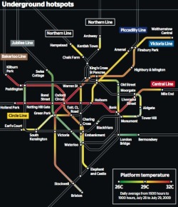
Luckily, many of my hours on the Tube were on the cooler Jubillee Line, and not on the Central Line. A new map compiled by Transport for London (TfL) has revealed the hottest spots on the Tube network, notorious for its lack of air-conditioning. For many, it proves that London has indeed become a melting pot. The Central Line — which serves some of the most popular tourist spots such as Oxford Street and St Paul’s Cathedral — is one to avoid on a hot day. The Central Line boasted some of the highest temperatures when the heat map was compiled on July 28 last year — the hottest day. Many sections of the tube reach over 30C (86F). Full-size graphic: Graphic: underground hotspots. From the Times, via the Map Room.